Yangmingshan East-West Thru Hike Guide: How to Bag 10 Peaks in A Day
How many mountains can you reach in a single day in Yangmingshan National Park? For the average hiker, the
Yangmingshan East-West Thru Hike offers the chance to bag 10 of the most stunning peaks in Yangmingshan
National Park, including Mt. Qixing and Mt. Datun.

This hike also encompasses two sections of the Taipei Grand Trail: Section 2 and Section 3. Start early
enough, and you'll be rewarded with a breathtaking sunrise over Keelung Islet and panoramic views of the
mountain layers surrounding the Taipei Basin. Get ready for an unforgettable adventure!

Disclaimer:
All content is for inspiration only. Use Taiwan Hikes' suggestions at your own risk. We are not responsible for any losses, injuries, or damages.
All content is for inspiration only. Use Taiwan Hikes' suggestions at your own risk. We are not responsible for any losses, injuries, or damages.
Table of Contents:
Trail Information: Yangmingshan East–West Vertical Traverse, Yangmingshan East to West Thru Hike 陽明山東西大縱走活動
Trail Name: Yangmingshan East–West Vertical Traverse, Yangmingshan East to
West Thru Hike 陽明山東西大縱走活動
Distance: 22.5 km (14 miles) according to my record
Route type: Point to point
Days/Hours Needed: 10-12 hours. The fastest record is 2 hours and 48 minutes, made by an ultra-runner Zhou Qing in 2021.
Total Ascent/Descent: 1,448 m/1,601m
Best Time to Go: Fall and Winter. Summer is too hot to hike.
Permits: Not required
Difficulty Level:
Peaks or Places to Reach
You can click the following peaks to jump to those sections.
- 1. Mt. Ding 頂山, 768 meters (2,519 feet). There is a Class 3 Triangulation Stone on the summit. The character on the post is Yang 陽.
- 2. Mt. Shiti or Shitiling 石梯嶺, 862 meters (2,828 feet). The character on the post is Ming 明. If you continue to Qingtiangang, you will reach Mt. Zhugao 竹篙山, 830 meters (2,723 feet). This peak isn't included in the peak bagging, but it's worth paying a visit.
- 3. Jixinlun 雞心崙, 763 meters (2,503 feet). The character on the post is Shan 山.
- 4. Mt. Qixing East Peak 七星山東峰, 1,108 meters (3,635 feet). There is a Class 3 Triangulation Stone on the top. The character on the post is Dong 東.
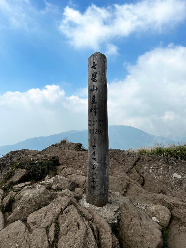
- 5. Mt. Qixing Main Peak 七星山主峰, 1,120 meters (3,674.5 feet). There is a Class 1 Triangulation Stone on the summit. The character on the post is Xi 西. Mt. Qixing is the highest peak in Taipei City and is also listed as No. 2 on the Minor 100 Peaks in Taiwan.
- 6. Mt. Datun Main Peak 大屯山, 1,092 meters (2,503 feet). The character on the post is Da 大. Mt. Datun is listed as No. 1 on the Minor 100 Peaks in Taiwan.
- 7. Mt. Datun South Peak 大屯山南峰, 957 meters (2,503 feet). The character on the post is Zong 縱.
- 8. Mt. Datun West Peak 大屯山西峰, 982 meters (2,503 feet). The character on the post is Zou 走.
- 9. Mt. Miantian 面天山, 977 meters (2,503 feet). There is a Class 3 Triangulation Stone on the summit. The character on the post is Huo 活.
- 10. Mt. Xiangtian 向天山, 949 meters (2,503 feet). The character on the post is Dong 動.
Those Chinese characters, in order, are the name of the Yangmingshan East–West Vertical Traverse in Chinese,
Yang Ming Shan Dong Xi Da Zong Zou Huo Dong 陽明山東西大縱走活動.

Additional Information:
- Many sections are exposed. Please bring enough water and do sun protection for your hike.
- Many stone steps are slippery, even if it's sunny. Please wear a pair of shoes with good traction.
- Using a stove is not allowed in Yangmingshan National Park.
- You can bring a water filter and draw water from the tap water to save some weight. Or fill up water at the visitor centers.

Map/GPX Data
GPX Track From
Click Menu in the map to download, print, or share the map.
You can see more options after clicking the Play button.
Click to change the speed to meet your condition.
You can see more options after clicking the Play button.
Click
to change the speed to meet your condition.
How to Get There: Hike from the Fengguikou side
- Take M1 市民小巴 from exit 1 (Taipei Art Performing Center, the ball) of MRT Jiantan Station. The earliest bus is at 6:10, and the next one is at 10:10. Get off at the last stop, Dingshan.
- Take S18 小18 from exit 1 of MRT Jiantan Station and get off at Shengren Bridge Stop. Then, walk up to Fengguikou, which takes around 40 minutes.

How to Get There: Hike from the Qingtian Temple side
Take S6 小6 from exit 1 of MRT Beitou Station and get off at the
last stop, Qingtian Temple.

Most hikers start from the Fengguikou side because there are more buses on the Qingtian Temple side to take after
finishing the hike. If you end on the Fengguikou side, you walk to the Shengren Bridge to take S18.
Details of My Yangmingshan Thru Hike
Brief itinerary: Fengguikou (Fengguizui) ➔ Mt. Ding ➔ Shitiling ➔ Jixinlun ➔
Lengshuikeng Visitor Center ➔ Mt. Qixing East Peak ➔ Mt. Qixing Main Peak ➔ Xiaoyoukeng
➔ Mt. Datun Main Peak ➔ Mt. Datun South Peak ➔ Mt. Datun West Peak ➔ Mt. Miantian
➔ Mt. Xiangtian ➔ Qingtian Temple
It took me three times to finish this thru-hike successfully, and doing it alone required extra willpower to
persist. However, I'm glad and proud that I made it on May 18, 2024.
I hailed a taxi directly to the Fengguikou trailhead to gain enough daylight to hike around 5:30 p.m. It was not
cheap, but I wish I had gotten up early because of the stunning sunrise near Fengguikou.
06:11 I arrived at Fengguikou (Fenggueikou) and went to the toilet nearby.

06:23 I started my hike after getting ready and taking a selfie with the post,
Bei 北. You will see markers saying the distance from Fengguikou to Qingtiangang is 6.4 km.

If you are not on a mission to finish this thru-hike in a day, this trail is so stunning and easy to hike.
The weather was good when I started. When I scaled higher, the place opened up, and I saw Keelung Islet on my right.
The sun rose not long ago, and the ocean around Keelung Islet still reflected the red hue.

The layers of mountains made the whole landscape even more breathtaking. I wish I had had gotten up here
earlier. I'll come back for the sunrise in the future.

This area is also home to feral buffaloes. They roam randomly, minding their own
business. Please keep a safe distance from them for your own safety.

1. Mt. Ding or Dingshan
06:56 I reached my first peak, Mt. Ding or Dingshan, 768 meters above sea level,
around 2 km from Fengguikou.

Soon, at 2.6 km, I entered the Japanese Cedar Forest, which has drastically different vegetation from the
previous grassland. Please spend more time here if you are not in a hurry like me.

After exiting the cedar forest, the landscape opened up again, and I saw Mt. Qixing Main Peak and East Peak, Mt.
Miantian, and Mt. Zhugao. Those were on my itinerary, and they looked so far away.

07:21 At 3.8 km, I reached Beiwuzhishan Grassland (Mt. North Wuzhi or North
Wuzhishan Grassland) 北五指山草原 with 360-degree views: Taipei 101 and Taipei Basin on one side and Mt. Keelung and
Mt. Teapot on the other. There's a Xinglin 杏林山 nearby, but I didn't go this time.


2. Mt. Shiti or Shitiling
07:32 I arrived at my 2nd peak, Mt. Shiti or Shitiling, 863 meters above sea
level. The views were incredible.


I passed the gate to the Mt.
Huangzui trail. This one requires permits to hike.

08:00 I arrived at Qingtiangang at 6.4 km. I've been here numerous times and
will never get tired of this place.

There are several junctions at Qingtiangang grassland. If you aim to finish the thru-hike, you should pay
attention to the route.

08:25 I reached Mt. Zhugao, 830 meters above sea level. The post of Mt. Zhugao
doesn't have a character to collect.

3. Jixinlun
08:50 I arrived at Jinxinlun. You will also see an observation deck here.

Then, I entered a cute footpath flanked by Japanese Cedar trees.

09:02 I arrived at the Jinshan Suspension Bridge, which is closed for
maintenance from May 24 to September 19, 2024.

After crossing the bridge, I was flanked by Bald Cypress trees, and this footpath is famous for the fall
foliage.

Lengshuikeng Visitor Center is not far from Jinshan Suspension Bridge and I took for a needed break because the
following 2.1 km would be daunting, endless, steep steps to Qixing East and East Peak. There were bus stops here
and they all lured me to give my hike up.

4. Mt. Qixing East Peak
09:17 The weather became warmer, and those steps to Mt. Qixing East Peak still
made me want to run away. I took a deep breath and made myself continue.

I took a long break at the two-story pavilion and passed the Nation Education Radio Station.

It took me 40 minutes to reach the 1 km marker, compared to my pace of 3.8 km during the first hour of this
hike. But remember to look back because the views were beautiful.

10:27 I reached Mt. Qixing East Peak, and the marker is 1.8 km, 1,107 meters
above sea level. I did this hike on Saturday, and the summit was packed with crowds. I continued to my next peak
without stopping.

5. Mt. Qixing Main Peak and Xiaoyoukeng
10:47 I finally reached the highest point of my hike, Mt. Qixing Main Peak, 1,120
meters above sea level. There was a long queue waiting for the peak photo.

Mt. Qixing North Peak wasn't far from the main peak, and I stood at the entrance for a while, debating whether I
should go. Meh, next time.

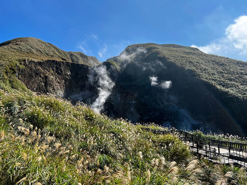
Since I had reached the highest peak for my hike, it went downhill to Xiaoyoukeng.

After passing the observation deck, I could see the Xiaoyoukeng Parking Lot. It was pretty steep, and I could
smell sulfur. The sulfur fumaroles emit the smoke.
11:22 From the Xiaoyoukeng Visitor Center, the trail is connected to the Bailaka
Highway 百拉卡公路. After a 5-minute walk, I reached the Bailaka Highway Pedestrian Trail 百拉卡人車分道. I was glad to be
back on the footpath again.


Almost half of this section was covered by shade. While walking next to Bailaka Highway, I saw Xiaoyoukeng in
the distance. It always amazes me to see how far I've gone.

6. Mt. Datun Main Peak
12:20 I reached the trailhead to Mt. Datun. This section is another taxing
section to overcome, especially when the weather is hot and humid.

13:24 The distance from the Datun Trailhead to Mt. Datun Main Peak is 1.6 km,
and it took me 64 minutes to finish. I don't remember how many breaks I'd taken, but I remember I swore too much
while dragging my feet. It was not my proud moment.

Mother Nature still granted me beautiful views of Mt. Datun Main Peak, but seeing the four peaks ahead of
me didn't make me thrilled. What awaited me were the endless steps.


7. Mt. Datun South Peak
The terrain to Mt. Datun South Peak was muddier and rougher than the steps.

14:10 I reached Mt. Datun South Peak. Half the sky cleared up again, but I
didn't stay long for the view. I left quickly for the next summit.

8. Mt. Datun West Peak
14:27 I arrived at the junction to Mt. Datun West Peak. This section was steeper
than the previous one, with steep slopes to climb. I took several breaks while ascending again.

14:50 Mt. Datun West Peak, 985 meters above sea level.

I could see the distinctive broadcasting panels on the tops of Mt. Miantian and Mt. Xiangtian. However, I failed
to reach both peaks during my first and second attempts.

Descending from the west peak is more challenging than the south peak. I think part of the reason is I was
already exhausted, and the muddy slope didn't help, either.

9. Mt. Miantian
15:17 I reached Miantianping Pavilion, a junction to Qingtian Temple, a
trailhead with a bus stop. At that moment, it was so tempting to go to the Qingtian Temple.

Then, I finally dragged my feet to the entrance of Mt. Miantian. The steep, endless steps didn't boost my morale
at all. Instead, seeing them induced way too many swear words from me. The pattern was the same as my struggle
to get to Mt. Datun.

16:03 I reached Mt. Miantian, 977 meters above sea level, and looked at my last
peak, Mt. Xiangtian. From Miantian to Mt. Xiangtian, I had to go down to the saddle and climb again on the
steps.


10. Mt. Xiangtian
On the way to Mt. Xiangtian, Mt. Qixiang Main Peak and Mt. Datun West Peak could be seen from the steps. I'd
gone so far.

16:20 I reached Mt. Xiangtian, 946 meters above sea level. This is not my
first-time hiking to Mt. Xiangtian, but it is my first time connecting 10 peaks in one go. Finally!

It had been 10 hours since I started this hike. After taking photos, I left Mt. Xiangtian and headed to
Xiangtian Pond to have a look. The water was dry, and no Fairy Shrimp were in sight.

16:50 I arrived at the junction to Qingtian Temple, and the sign said it was 1.6
km away.

17:16 I reached Qingtian Temple, and I did it! I was hoping to finish this
thru-hike in 10 hours, but I'm still happy with 11 hours.

One thing for sure is that I don't want to hear about the Yangmingshan East to West Thru-hike for a while, but
who knows? Perhaps I will do it again from the West/Qingtian side in 2024.
About Yangmingshan and Taipei Grand Trail 台北大縱走
About Yangmingshan National Park
Yangmingshan National Park, located at the northern edge of Taipei Basin, is one of the nine national parks in
Taiwan. Yangmingshan is surrounded on the north by Mt. Zhuzi 竹子山, on the east by Mt. Huangzui 磺嘴山 and Mt. Wuzhi
五指山, on the south by Mt. Shamao 紗帽山, and on the west by Mt. Honglu 烘爐山 and Mt. Miantian 面天山 (part of Datun
Volcano Group). Mt. Huangzui is the biggest volcano crater at Yangmingshan.
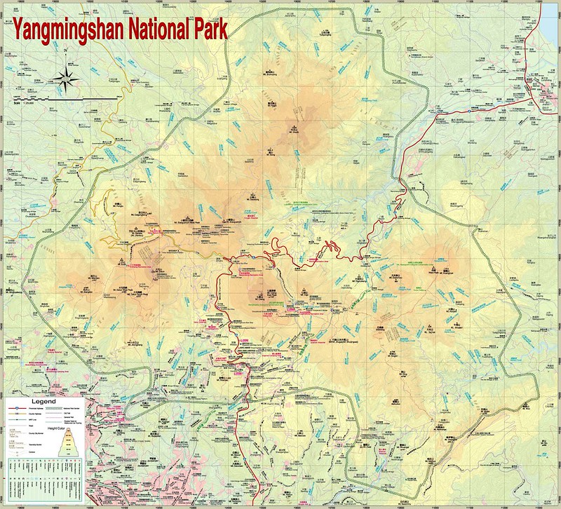
The area of Yangmingshan, 11,334 hectares (28,007 acres), covers many districts of Taipei City and New Taipei
City, and the altitude ranges from 200 to 1,120 meters above sea level. The highest mountain at Yangmingshan,
also in Taipei City, is Mt. Qixing 七星山, 1,120 meters above sea level.
In Chinese, Shan literally means mountain. Thus, Yangmingshan is Yangming Mountain. Actually, you will NOT find
any mountain at Yangmingshan National Park called Yangming Mountain. Yangmingshan, Caoshan 草山, or Grass
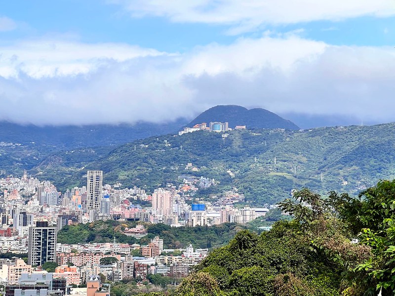
Mountain, is a general name that refers to Mt. Datun, Mt. Qixing, and Mt. Shamao.
However, there is a Caoshan or Grass Mountain near Mt.
Canguanliao 燦光寮山 in Ruifang 瑞芳.
Volcanic Activities at Yangmingshan:
Sitting on the Pacific Ring of Fire, experiencing constant earthquakes is a part of daily life for people who
call Taiwan home.
The landforms at Yangmingshan are shaped by the Datun Volcano Group 大屯火山群. According to Yangmingshan
National Park, Datun Volcano Group was most active between 800,000 and 600,000 years ago.
Frequent eruptions occurred at Mt. Ding Huo Qiao, aka Mt. Jhongfuzhih 丁火巧山 or 中幅子山 (471 meters), around 2.8 to
2.5 million years ago.
Mt. Zhuzi 竹子山, Mt. Qixing, Mt. Huangzui, and Mt. Xiaoguanyin 小觀音山 frequently erupted between 800,000 and 300,000
years ago.

Then, only Mt. Honglu and Mt. Miantian erupted frequently, and Mt. Shamao was formed. After that, Datun Volcano
Group became dormant.
It is said that the last eruption of Datun Volcano Group was 6,000 years ago.
Taipei Grand Trail 台北大縱走
Taipei Grand Trail is popular among local hikers. There are 8 sections of this hike, and the total distance is
130 km (80.7 miles). You can find all the things, GPX, things and history from Taipei City Geotechnical Engineering Office's website.
You can follow and fulfill the requirements while taking those sections, you can apply for the certificate and
win prizes.
