Navigating Mt. Dabajian: Your Comprehensive Guide to Permits, Public Transport, and Trail Insights
As one of the three mountains (Jade Mountain and Nanhu Mountain) depicted on the banknotes in Taiwan, Dabajian
Mountain is one of the most popular 100 Peaks trails.

For seasoned hikers or those looking for challenges, you can also take a different route to enjoy the
magnificent high mountains that Taiwan can offer. You will find information about the various routes to Mt.
Dabajian, Holy Ridge Trail (aka Shengleng Trail), and the other 100 Peaks at Shei-Pa National Park.
Please check Shei-Pa National Park's website before you do this hike.
Important: Jiujiu Cabin is set for renovation from March 30, 2026, to December 2028. The total number of beds
will be reduced from 150 to 70, including 10 designated for advanced applications. In other words, only 10
beds for advanced foreign applications are available from March 30, 2026.
Disclaimer:
All content is for inspiration only. Use Taiwan Hikes' suggestions at your own risk. We are not responsible for any losses, injuries, or damages.
All content is for inspiration only. Use Taiwan Hikes' suggestions at your own risk. We are not responsible for any losses, injuries, or damages.
Table of Contents:
- Trail Information and Map/GPX Data
- How to Get There: Taiwan Tourist Shuttle Service - Guanwu Route
- How to Apply for Permits and Book Meals
- Journey Through the Peaks: Details of the Daba Route of Mt. Dabajian and Mt. Xiaobajian
- About Mt. Dabajian, Shei-Pa National Park, and Holy Ridge (Shengleng Trail)
- Related Posts
Exploring Taiwan? Save Time with the Ultimate 2026 Hiking Guide! Discover the top hikes in every city and
county across Taiwan—all accessible by public transport (bus links available). We've spent 35+ hours
researching the best trails and transit options, so you can skip the hassle and start your adventure!

Trail Information and Map/GPX Data
Trail Name: Mt. Dabajian and Mt. Xiaobajian 大小霸尖山
Distance: 62 km (38.5 miles)
Route type: Out-and-back
Days/Hours Needed: At least three days for average hikers. Some extremely hikers do it in one day.
Total Ascent/Descent: 1442m/1442m
Best Time to Go: All year round, but the Shei-pa National Park will check hikers' hiking experience or certificates during the snow season. Bring gear for hiking in the snow is a must.
Permits: Required. See How to Apply for Permits and Book Meals.
Difficulty Level:
Peaks to Reach:
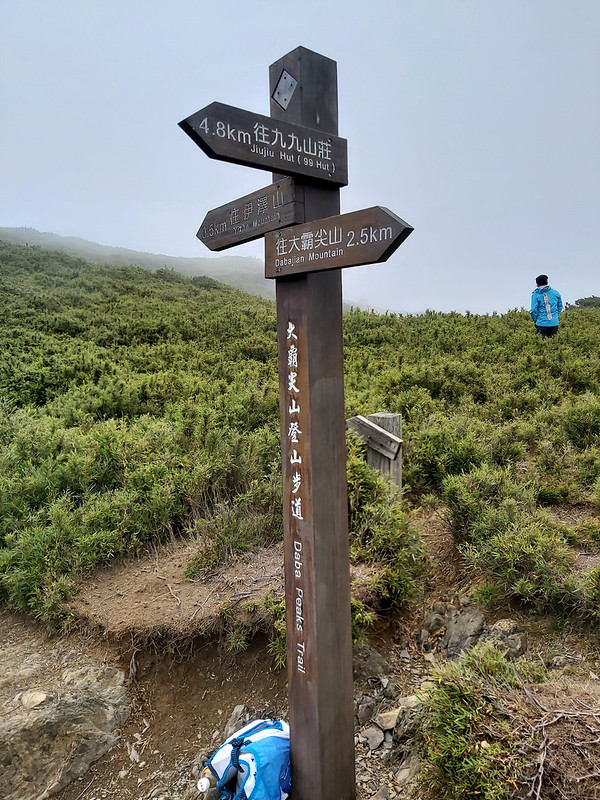
- Mt. Dabajian 大霸尖山: 3,492 meters (11,456 feet), a Class 2 Triangulation Stone on the peak.
- Mt. Xiaobajian 小霸尖山: 3,418 meters (11,214 feet)
- Mt. Yizhe 伊澤山: 3,297 meters (10,817 feet), a Class 3 Triangulation Stone on the peak.
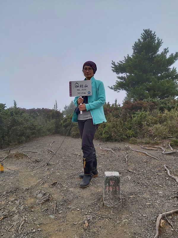
- Mt. Jiali 加利山: 3,112 meters (10,210 feet), a Class 3 Triangulation Stone on the peak.
Things to Know before You Go
- It may take some luck to win the lottery of Jiujiu Cabin.
- If you do the Daba Route, you can take your bike to make the Dalu Forest Road easier.
- The water at Zhongba Hut (Jhongba Hut) is not stable. Therefore, you might need to carry water from Jiujiu Cabin.
- If you stay at Zhongba Hut for two nights, you must hike at least 27 km from Zhongba Hut to Mt. Dabajian Checkpoint.
- Sumida Cliff can be scary for people who don't like height. Unfortunately, it can be dangerous, too.
- If you decide to camp at Wuling Farm on the previous day, be aware of the aggressive wild monkeys. They take human food. Please don't feed them, either.
- Remember to bring a light backpack for your visit to Mt. Dabajian on the second day. You only need to get the essentials like water, rain gear, trail meals, etc., in it.
Phone Receptions: You will see the posts with bright yellow signs telling you which telecom companies can get the internet.
- On Dalu Forest Road: you will find a good phone reception on Dalu Forest Road.
- Between Madara River Trailhead and Jiujiu Cabin: after crossing the Madara River, only ChungHwa Telecom users can get the best reception.
- At Jiujiu Cabin and Zhongba Hut: the internet reception is incredibly good.
- Mt. Dabajian, Mt. Xiaobajian: good.
- The rest: I turned on airplane mode to save battery power, but you will see posts with yellow signs if there's phone reception.
Map/GPX Data
Dates of Hike: I did this trail twice. The first one was on September 3rd, and the second one was on July 8th,
2022.
Route map for Dabajian And Xiaobajian Updated by Anusha Lee on plotaroute.com
Click Menu in the map to download, print, or share the map.
You can see more options after clicking the Play button.
Click to change the speed to meet your condition.
You can see more options after clicking the Play button.
Click
to change the speed to meet your condition.
How to Get There: Taiwan Tourist Shuttle Service - Guanwu Route
From Taiwan Highspeed Rail Hsinchu Station to Guanwu Villa.
Bus stop: Platform 6 at Exit 4 of Taiwan Highspeed Rail Hsinchu Station.
Bus fare: NT$300 one trip
Driving time: Around 2 hours 25 minutes depending on traffic
Timetable:
From HSR Hsinchu Station to Guanwu Villa: 07:10, 13:10
From Guanwu Villa to HSR Hsinchu Station: 10:10, 16:10
Please check the Taiwan Tourist Shuttle website for the latest timetable.
Please make a reservation online or call +886- 911-363-360. (NT$100 for reservation
deposit)
According to the bus company, passengers can only make a reservation 30 days but no later than 4 days before
departure (the bus company mentions this only on their Chinese website).
If you have a bigger group, hiring a private car is recommended.
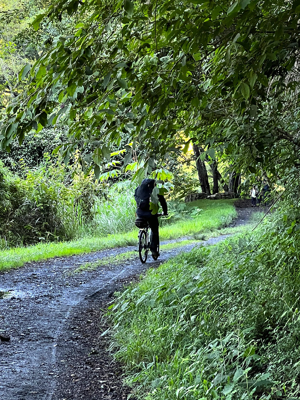
If you don't want to hike on Dalu Forest Road, 34 km round trips, you can rent or ride your own bike to the
actual trailhead near Madara River 馬達拉溪. Shei-Pa National Park relaxed the regulations of riding a bike, except
for electric bikes, on May 20th, 2022, for one year.
Bike entry is allowed between 8 am and 5 pm. Cyclists must scan QR codes at the Mt. Dabajian checkpoint.
However, the Dalu Forest Road condition isn't as good as a bike trail. Please ride with caution.
How to Apply for Permits and Book Meals
Send your application to Hike Smart Taiwan Service 臺灣登山申請一站式服務網.

Since "Hike Smart Taiwan Service" has been improved and made more straightforward, I have only included a short
video to help you understand how to use the website.

The permit application process for Mt. Dabajian is similar to that of Xue Mountain (Xueshan), as Shei-Pa
National Park manages both. The application system and timeline are nearly the same, but the route and
accommodation arrangements differ. If you’ve applied for Xueshan before, the Dabajian process will feel
familiar—make sure to review the specific route details in advance.
Please note that the Advanced Applications are only for hiking Xue Mountain (Xueshan) Trail and Daba Peaks (Mt. Dabajian)
Trail. There are no Advanced Applications preserved for Wuling Quadruple Mountains Trail.
Itinerary reference:
Day 1: Mt. Dabajian Checkpoint ➔ Madala (Madara) Trailhead ➔ Jiujiu Cabin
Day 2: Jiujiu Cabin ➔ Junction to Mt. Jiali ➔ Junction to Mt. Yizhe ➔ Zhongba Hut (Jhongba Hut) ➔ Zhongbaping ➔ Mt. Dabajian ➔ Mt. Xiaobajian ➔ Mt. Dabajian ➔ Zhongba Hut ➔ Jiujiu Cabin
Day 3: Jiujiu Cabin ➔ Madala (Madara) Trailhead ➔ Mt. Dabajian Checkpoint
Standard Application v.s. Foreign Advanced Application
If you are an Alien Resident Certificate or an exchange student, you still have to click
Standard Application.
If you are a tourist from other countries, you can click Foreign Advanced Application. The difference is that
Jiujiu Cabin will preserve a certain number of beds to ensure they can arrange their travel in advance.
No Need to Apply for the Police Mountain Entry Permit
Catering Service for Sleeping Bags/Meals:
Contact Bunun Climbers 布農卡里布灣 for your catering service to hike Mt. Dabajian (Jiujiu
Cabin), Wuling Quadruple Mountains, and Xueshan.
Journey Through the Peaks: Details of the Daba Route of Mt. Dabajian and Mt. Xiaobajian
This route is the easiest and also the most popular one to enjoy Mt. Dabajian. There are different trails if you
are opt for more challenging hikes. Please read my post about Holy Ridge Trail for details.
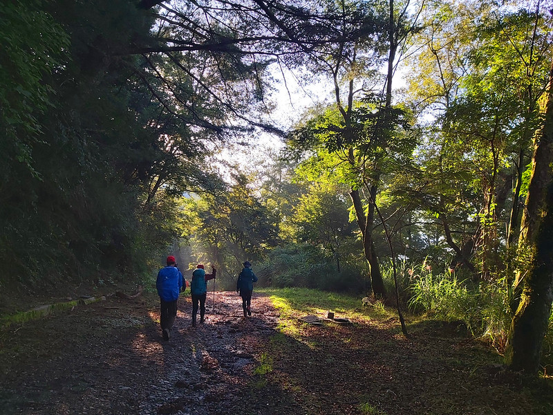
Day 1 Itinerary: Dalu Forest Road: From Excitement to Boredom
Day 1 brief itinerary: Mt. Dabajian Checkpoint (2,039 meters) ➔ Madara River Bridge (1,818
meters), where the actual hike starts ➔ Jiujiu Cabin (2,699 meters)
It takes 4 to 5 hours to finish Dalu Forest Road East Line. However, I suggest you make it quick since it's
mostly downhill because it will take 4 hours to complete the 4.1km hike to Jiujiu Cabin.

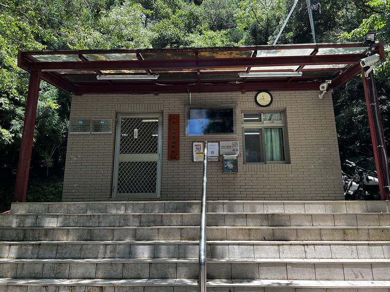
You will go through the gate of Mt. Dabajian Checkpoint and submit your documents or in the mailbox scan QR code
if you ride a bike.
If you don't ride a bike on Dalu Forest Road, the 17km hike starts from here and goes down to Madara River to
the actual trailhead of Mt. Dabajian.
Although it's a gradual descent, you will still go through some ups and downs. The trail terrain of Dalu Forest
Road is relatively easy. You will find big tables and chairs to rest.
Please be aware of Stingy Nettles, especially when trying to find a place to release yourself. They are almost
everywhere on the road. No toilets on Dalu Forest Road, either. I brushed my thigh against them on the way back.
Not fun.

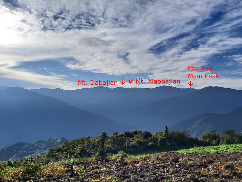
You will find millage posts every 100 meters. After a 9km post, you can see Mt. Yizhe and Mt. Jiali on the
ridge.

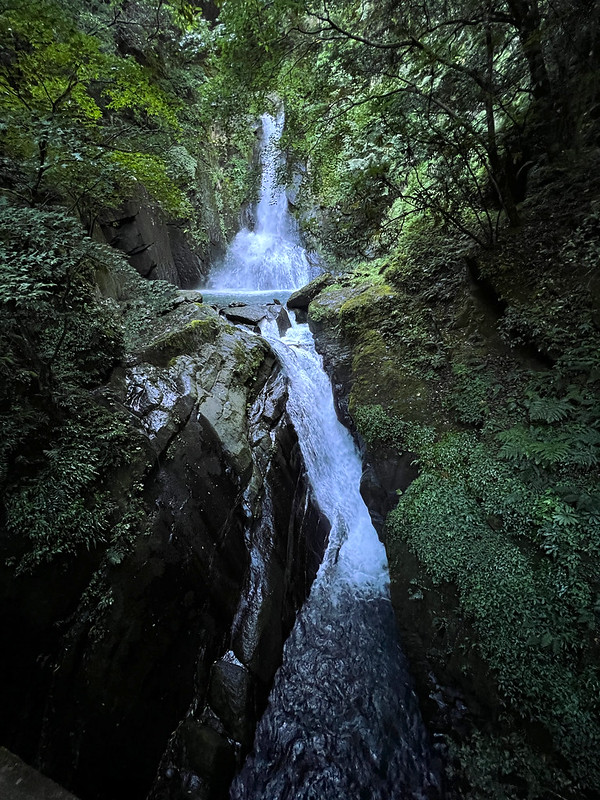
At 14.5 km, you will see a bride with a long waterfall. That is Dongxian Waterfall 東線瀑布. From here, 2.5 km to go
to the actual trailhead.
When I started taking Dalu Forest Road, I was still excited about doing this hike and admired the forests I saw.
Gradually, the excitement subsided, and it was replaced by boredom. Whenever a cyclist passed me, I gave them a
look of jealousy. At least, I was jealous of them taking the bike and wished I could have done the same.
Then, I saw an ample space with a post pointing to Madara River Trailhead.

Before taking the shortcut, you can take a break at the massive stone table and chairs. After that, the shortcut
is a steep slope that takes about 5 minutes to pass.
If you don't take the shortcut, there will be another 2 km to Madara River Trailhead.
You will see some bikes parked at the fence.

There is a shelter at the bottom of the steep slope. Some hikers will stay here for one night.
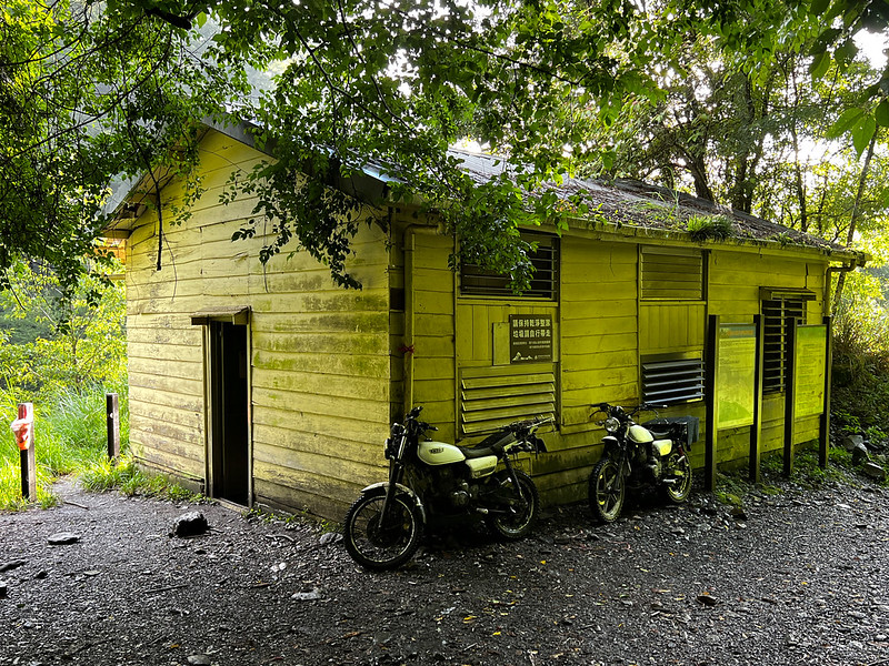
There is an old checkpoint nearby. We met a solo hiker staying there overnight. But I was told that the
foundation of that old checkpoint was eroded.

Day 1 Itinerary: The Real Hike Began: 900 Meters of Elevation Gain in 4.1 km
While crossing the Madara River Bridge, I saw the ruined suspension bridge. Some hikers said they could drive on
Dalu Forest Road and start the hike to Mt. Dabajian right here many years ago before the bridge was distorted.


There is a slope passing next to the collapsed bridge. From here, it's a 4.1 km fun hike to Jiujiu Cabin, and
this took me 4 hours to finish the climbing.

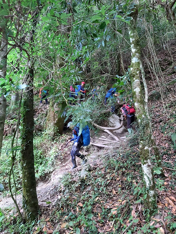
The trail terrain is no longer flat and friendly. We had to walk on sections of rocks or intertwined tree roots.
It will be slippery if it rains.
Since this is a popular hiking trail, we saw several porters carrying food and gas cylinders climbing up. This
is a tough job.
For new hikers, climbing up to Jiujiu Cabin is tough, too. We took several breaks to catch our breath. Then,
finally, we saw the gate we had been waiting for, Jiujiu Cabin.

Amenities at Jiujiu Cabin and the Stunning Sunset
Most hikers will on-site catering services for meals and sleeping bag rentals to save some weight. There's a
kitchen if you want to cook your meals with your stove.
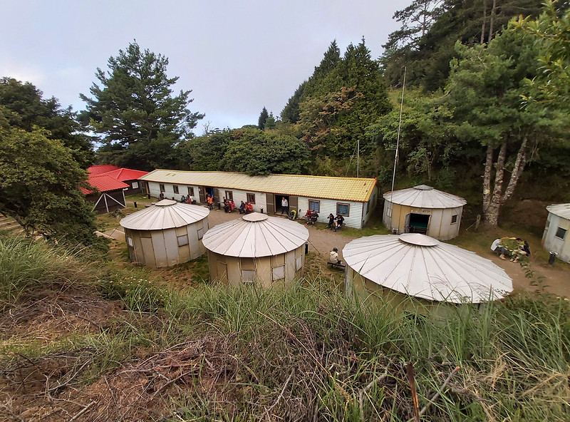

You will be assigned to either the small huts or the big house, depending on your group size. There are several
toilets, too.

No camping is allowed here.

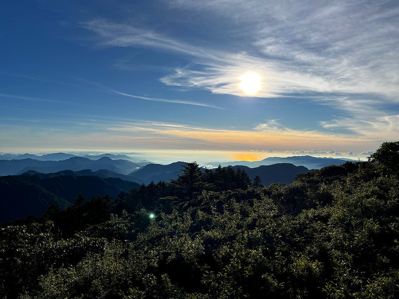
If you arrive at Jiujiu Cabin before sunset, please go past the solar panels to a slope. You will find hikers
gathering there, waiting for the sunset. This one was taken by my friend Jeffery Chang 張建舫.

Day 2 Itinerary: Another Steep Climb to the Junction of Mt. Jiali
Day 2 brief itinerary: Jiujiu Cabin (2,699 meters) ➔ Junction to Mt. Jiali (3,152 meters) ➔
Junction to Mt. Yizhe (3,220 meters) ➔ Zhongba Hut (3,297 meters) ➔ Zhongbaping ➔ Mt.
Dabajian (3,490 meters) ➔ Mt. Xiaobajian (3,419 meters) ➔ Mt. Dabajian ➔ Zhongbaping (3,400
meters) ➔ Zhongba Hut ➔ Mt. Yizhe (3,296 meters) ➔ Mt. Jiali (3,112 meters) ➔ Jiujiu
Cabin
Most hikers will start their hike to Mt. Dabajian and the other three peaks at 3 am if they start their hike
from Jiujiu Cabin. However, you can head out later if you stay at Zhongba Hut.
The junction of Mt. Jiali is at 6 km. There is an elevation gain of 450+ meters in 2 km. The distance from this
junction to Mt. Jiali is 1 km one way.
3050 Highland is around here. Some hikers say the view is great here, but I didn't get a chance to see the view
during a good weather. This is a good place to enjoy Taiwan alpine rhododendron blossoms in Spring. There is a
helipad near the junction. Again, I didn't see it, either.
After this junction, the rest of the trail to Mt. Dabajian is relatively flat. So, I suggest you go to Mt.
Dabajian and visit Mt. Jiali and Mt. Yizhe later.
During my second visit to Mt. Dabajian, I skipped Mt. Jiali and Mt. Yizhe because I was tired druing my second
hike, and it started raining, nothing much to see anyway.

The junction to Mt. Yizhe is at 8.8 km, and it takes 10 minutes to reach the peak one way.
On the way to Mt. Dabajian, you will see a small shelter, Zhongba Hut (Jhongba Hut). Zhongba Hut can accommodate
around 12 hikers, and only one or two tents can be pitched at the front. I like this cabin better than Jiujiu
Cabin. I am never a fan of big cabins unless I am the only one staying there.


Day 2 Itinerary: Amazing Zhongbaping to See Turtle Island
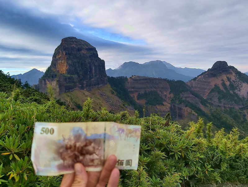
If you stay at Zhongba Hut at 9.6 km, I recommend you get up early to enjoy the stunning 360∘ views of
Zhongbaping and sunrise. The distance from Zhongba Hut to Mt. Dabajian is 1.3 km.
I never knew that we could see Turtle Island, which is 80 km (49.7
miles) away from Zhongbaping.

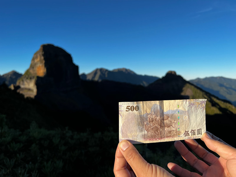
We spent a lot of time enjoying the surroundings at Zhongbaping, and, of course, taking photos with NT$500
banknote. The mountain depicted on the back of NT$500 is Mt. Dabajian.
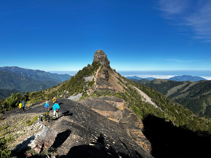
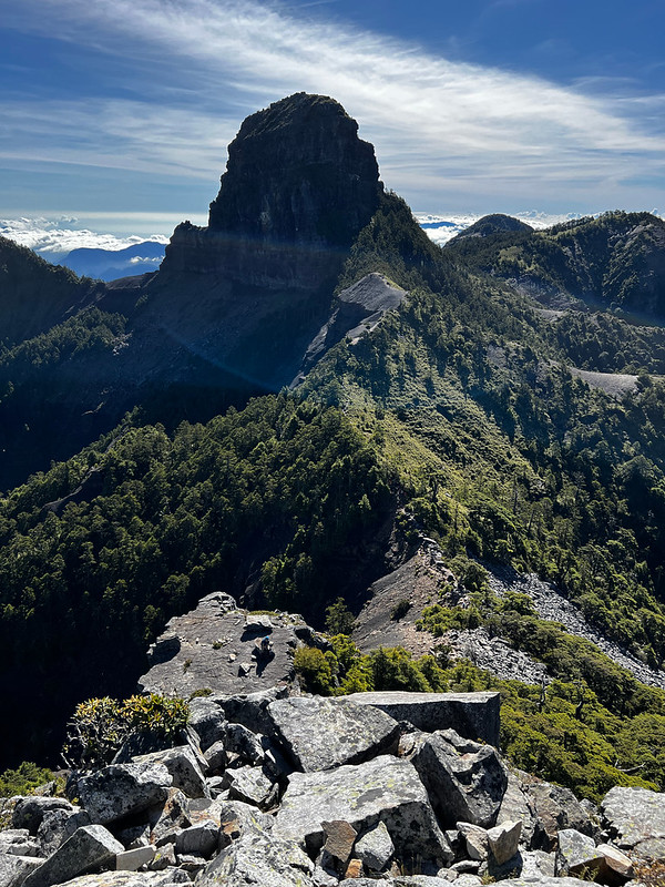
After Zhongbaping, we went downhill for a while and saw the mountain we'd been waiting for: Mt. Dabajian, at
10.9 km.
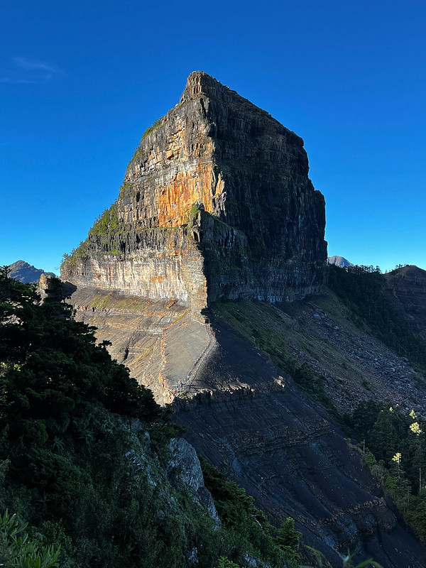
Day 2 Itinerary: The Famous Mt. Dabajian
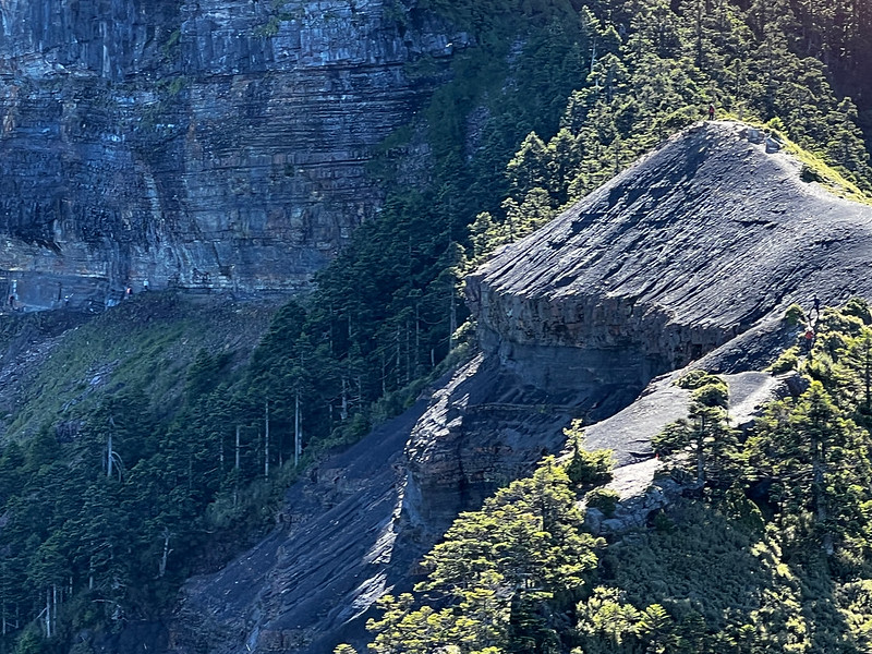
From there, hikers looked like ants, and the shape of Mt. Dabajian seemed so different. It looked so pointed.

In fact, Mt. Dabajian has many shapes if you see it from different places.
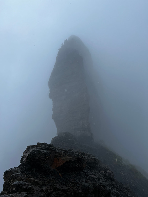

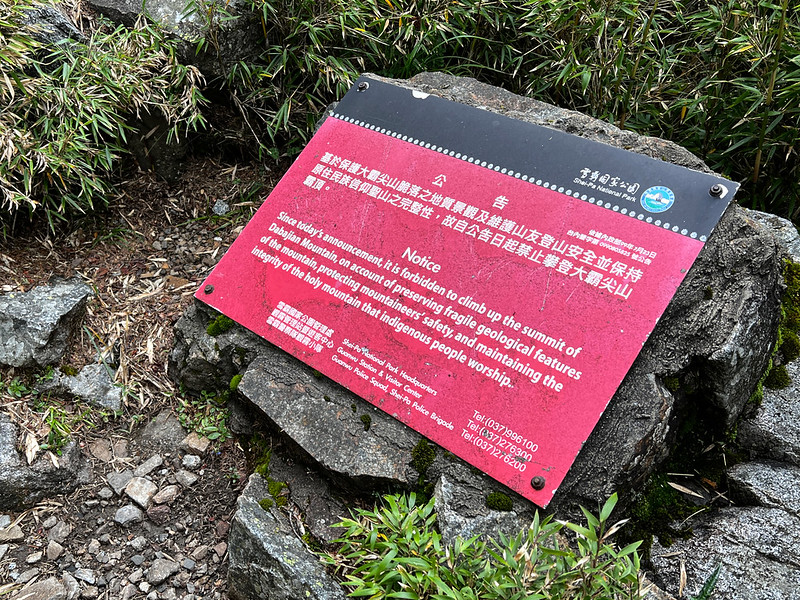
On July 23rd, 2010, Shei-Pa National Park banned hikers from climbing to the top of Mt. Dabajian because Mt.
Dabajian is the sacred mountain for Taiwan indigenous people Atayal 泰雅族 and Saisiyat 賽夏族.
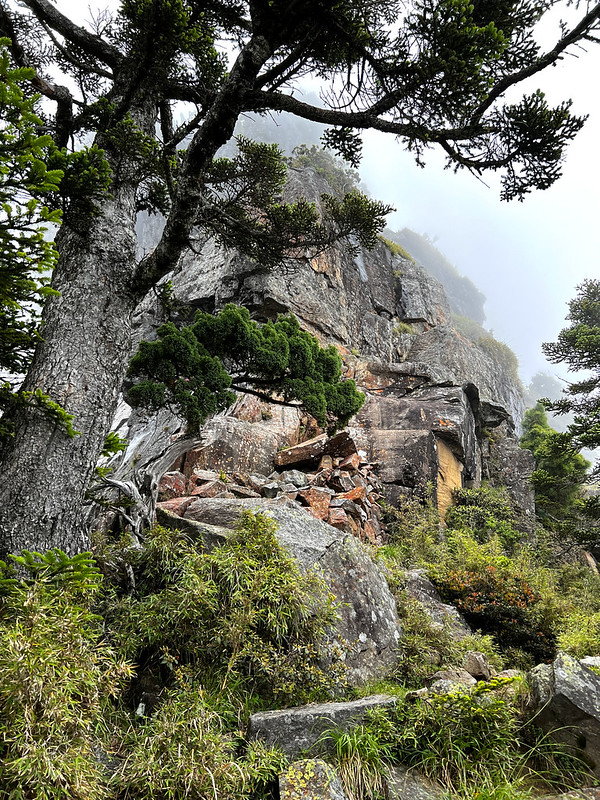
The entrance to the top is behind this footpath. To be honest, I didn't even dare to think about trying to climb
to the top.
Day 2 Itinerary: An Adrenaline Rush on the Ridge to Mt. Xiaobajian
After finishing the peak photos, we quickly passed the basal of Mt. Dabajian. When you go through the footpath,
please proceed with caution.

The footpath can be wet from the water dripping from Mt. Dabajian, and you might bump your head against the rock
when you turn.

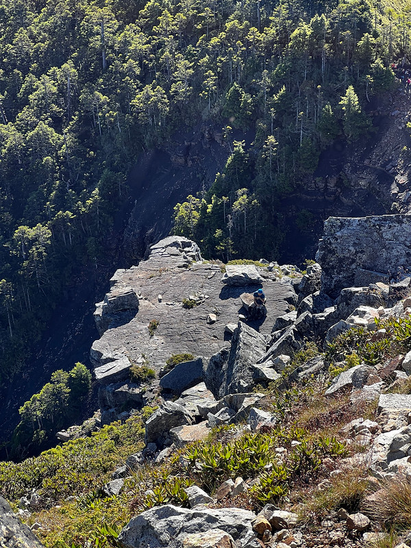
We passed the basal within 10 minutes and reached the ridge. Facing toward Mt. Xiaobajian, I saw the Holy Ridge
on my left side.

While on the ridge, I turned back to check out Mt. Dabajian and saw this beautiful silhouette.

Finally, we reached the basal of Mt. Xiaobajian. Suddenly, Mt. Xiaobajian looked huge.

After some hikers left Mt. Xiaobajian, we started climbing to the top. I left my trekking poles in the bush
because they would become a hinder when climbing.
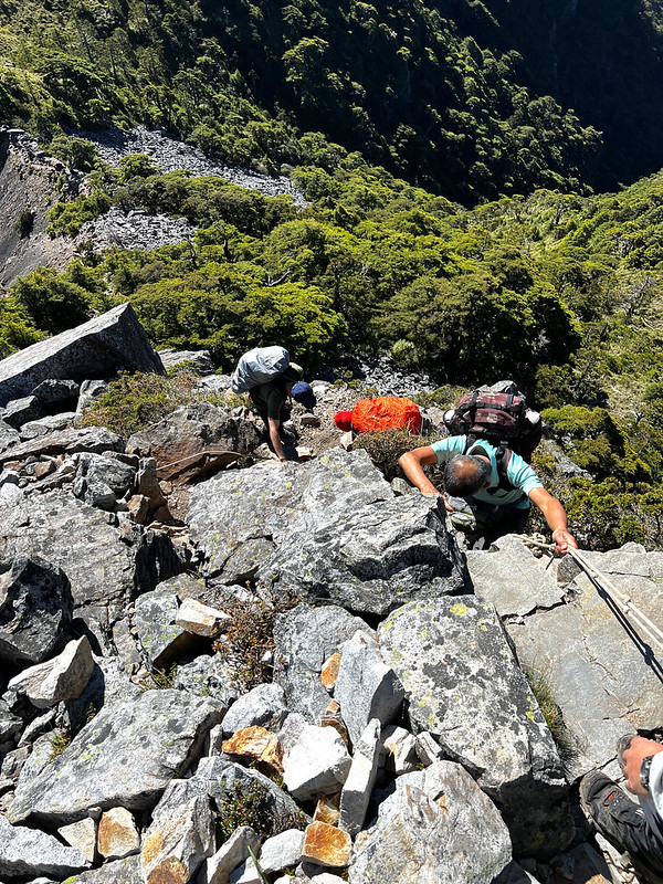
Please also make sure there aren't too many people when you are climbing to the top. You don't want to get stuck
there.
It took me less than 10 minutes to reach the top. It was still crowded when we were there, and the space was
small.
When I did my first hike to Mt. Xiaobajian, it was cloudy. I couldn't see anything. With sunny weather during my
second hike, it looked amazing.
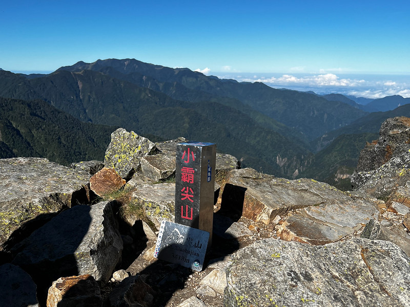
The shape of Mt. Dabajian changed again when I was on the top of Mt. Xiaobajian.
Time to get back to our cabin. We took the same ridge back. The ridge looked like a scary slide from here.
After finishing Mt. Xiaobajian and Mt. Dabajian, you can visit Mt. Yizhe and Mt. Jiali. Then back to Jiujiu
Cabin.

Day 3 Itinerary: Back to Dalu Forest Road, from Boredom to Still Boredom
You take the same way back to Mt. Dabajian Checkpoint. It's just this time hiking on Dalu Forest Road will turn
from boring to dreadful, because you've known what it's like already.
My hiking mates and I kept counting down the millage posts till I grew tired of it. Finally, I told them I
didn't want to do this hike again, but I knew I was lying.

Worth Mentioning: Beautiful Guanwu Villa
If you are not in a hurry to go home, please spend some time at Guanwu Villa. The view from this villa's
restaurant is fantastic.

The whole Holy Ridge was presented in front of us.

There are several relaxing trails near the villa that are great for strolling.
About Mt. Dabajian, Shei-Pa National Park, and Holy Ridge (Shengleng Trail)
Mt. Dabajian and Mt. Xiaobajian
Mt. Dabajian 大霸尖山 is the mountain that every Taiwanese sees daily, probably without even knowing it because this
mountain is depicted on the back of the NT$500 banknote. For many hikers in Taiwan, hiking to those mountains is
on their bucket list.
Mt. Dabajian and Mt. Xiaobajian are the sacred mountains for Taiwan indigenous people Atayal 泰雅族 and Saisiyat
賽夏族. Atayal people call those two mountains Babo Papak, meaning two ears 雙耳嶽. Those two peaks do look like ears
from a distance.

In Chinese, Da 大 means big, Xiao 小 means small, and Jian means peaks. That's why you see Daba Peaks written on
the permit application page. While hiking on other trails, I could see those fantastic peaks from a distance.
There was a ladder going to the top of Mt. Dabajian, but the ladder was worn out and became too dangerous to
climb. The most important thing is the peak is Atayal's sacred place.
To respect their culture and for the safety of hikers, Shei-Pa National Park 雪霸國家公園 removed the ladder in 1991
and banned climbing to the top in 2010.
Mt. Dabajian and Mt. Xiaobajian belong to the Snow Mountain Range 雪山山脈. Therefore, here are several hiking
routes to get close to those amazing mountains. Here, I hiked on the most popular and the easiest one, Mt.
Dabajian Trail.
As to Mt. Yizhe 伊澤山 and Mt. Jiali 加利山 those are listed on the 100 Peaks, and Mt. Yizhe is the northeast peak
among the 100 Peaks list.
About Shei-Pa National Park
Before we start, some confusing translations need to be clarified first.

Shei means snow in Chinese, and here it refers to Snow Mountain. Pa is a different translation of Ba and refers
to Mt. Dabajian here.

Shei-Pa National Park is the 5th one in Taiwan. The most famous tourist attraction at the park is Wuling Farm
武陵農場. Wuling Farm attracts thousands of tourists to enjoy the beautiful flowers during cherry tree blossoms.

Please visit Shei-Pa National Park for more information.
Holy Ridge Trail (Shengleng Trail)
Holy Ridge
refers to the ridges between Snow Mountain and Mt. Dabajian, and most of the elevation is 3,000 meters above sea
level. This name was first brought up by a Japanese climber Numai Tetsutarō 沼井鐵太郎 in 1928.

There are several routes to take on this thru hike, but none is easy. Hikers can take on some of the peaks on
the Holy Ridge instead of doing it all at once.