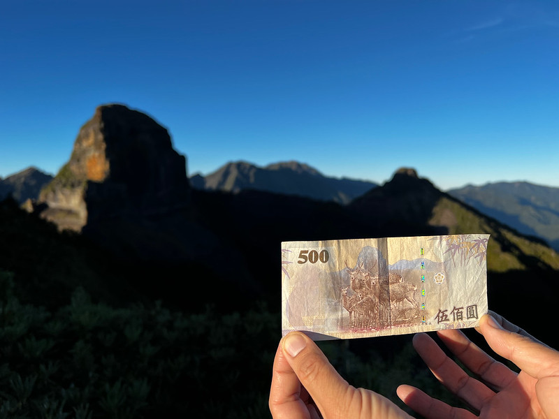
Explore the Holy Ridge in Taiwan: The Essential Shengleng Trail Guide with I, Y, and O Routes!
Tackle the Holy Ridge hike in Taiwan, a journey that weaves through the heart of the island's magnificent
mountains. Known as the Shengleng Trail, this path is not just a trek but a ritual of passage for adventurers.
Picture yourself traversing steep ridges, dangerous cliffs, and lush forests and witnessing panoramas that
stretch beyond horizons.

This guide is your key to unlocking the secrets of this majestic trail, a companion for those ready to embrace
the wild heart of Taiwan's highlands. You will find the details of the most popular routes, Holy Ridge I, Y,
and O Route, and what to expect.

This post focuses on the different routes of the Holy Ridge Trail and the dangerous sections that hikers need
to pay extra attention to. This hike is not for anyone, and being fit is not enough. If you are new to the
trails in Taiwan, hiring a qualified hiking guide is highly recommended.

Disclaimer:
All content is for inspiration only. Use Taiwan Hikes' suggestions at your own risk. We are not responsible for any losses, injuries, or damages.
All content is for inspiration only. Use Taiwan Hikes' suggestions at your own risk. We are not responsible for any losses, injuries, or damages.
Table of Contents:
- How Did the Name of Taiwan's Holy Ridge, a.k.a. Shengleng Trail, Come From?
- Trail Information: I Route, and Map/GPX
- Trail Information: Y Route, and Map/GPX
- Trail Information: O Route, and Map/GPX
- Holy Ridge Y Route in 4 Days - Only for Super Fit
- Hiking Permits, Transport, and Variations of Spellings on Shie-Pa National Park Website
- Related Posts
How Did the Name of Taiwan's Holy Ridge, a.k.a. Shengleng Trail, Come From?
Before we start, I want to thank Huiping 惠萍, Xiuting 秀庭, Yanjun 彥君, and Acer Lee 景泰 for sharing their
breathtaking journey and letting me use their images on this hike. Huiping, Xiuting, and Acer are trained
hiking guides, and Yanjun is a registered nurse.
I want to thank Jin Jin 惠津, also a trained hiking guide, for letting me use her photos of the
famous/notorious Pintian Cliffs and Sumida Cliffs.
The name "Holy Ridge" traces back to Tetsutarō Numai 沼井鐵太郎, the secretary-general of the Taiwan Mountaineering
Association, who first ascended Mt. Dabajian in 1927. In 1928, he published an article detailing his
exploration, poetically describing:
...this sacred ridge! Who can truly complete the traverse from Mt. Dabajian to Snow Mountain (Xueshan), don the crown of victory, and recount the truth and beauty of being the first to complete this journey?...

Thus, this ridge was named the "Holy Ridge 聖稜線," also known in the mountaineering community as the "I-Sheng,"
"I" Route, or the "Traditional Holy Ridge." On this traditional route, only three peaks are listed as part of
Taiwan's 100 Peaks: Mt. Dabajian, Snow Mountain North Peak, and Snow Mountain Main Peak.
Although other mountains on the ridge do not make this 100-Peaks list, their heights are considerable, and
their unique shapes solidify the ridge's revered status. The name "Holy Ridge" is indeed well-deserved!
Shengleng Trail I Route is also the first route among all, or the Traditional Holy Ridge route. The Y and O
Route are derived from the I one.

Trail Information: I Route, and Map/GPX
Distance: 59.2 km (36.8 miles)
Route type: Point-to-point between Xueshan Trailhead and Guanwu (the trailhead to Mt. Dabajian)
Days/Hours Needed: 6 days
Best Time to Go: Spring, summer and fall. Snow season usually starts from January to March. Please check National Park's website for the gear requirement.
Permits: The national park permits are required. The Police Mountain Entry Permits are no longer needed.
Difficulty Level:
Peaks or Places to Reach
- 1. Mt. Xue East Peak, Xueshan East Peak 雪山東峰, 3,201 meters (10,502 feet) above sea level. (100 Peaks)
- 2. Mt. Xue, Xueshan, Mt. Suye, Suye Mountain, Mt. Snow, Mt. Sylvia Main Peak 雪山主峰, 3,886 meters (12,749 feet). (100 Peaks)
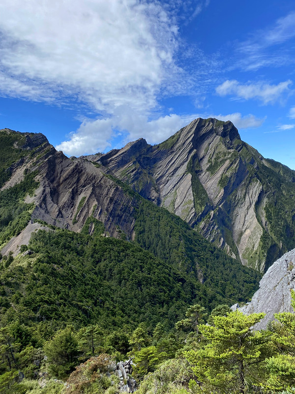
- 3. Beilengjiao 北稜角, or North Corner of Mt. Xue, 3,882 meters (12,736 feet). While the Matterhorn is the most famous horn peak worldwide, it is said that Beilengjiao is its counterpart in Taiwan. Shaped by glacial erosion millions of years ago, Beilengjiao and Xueshan Main Peak are two dome-shaped twin peaks roughly 450 meters apart in a north-south direction.
- 4. Mt. Kailantekun 凱蘭特崑山 3,731 meters (12,241 feet).
- 5. Mt. Xue, Xueshan, Mt. Snow, North Peak 雪山北峰, 3,703 meters (12,749 feet). The indigenous Atayal people call it Babo Tarakusya.
- 6. Mt. Mutelebu 穆特勒布山 3,626 meters (11,896 feet). This mountain is close to Sumida Cabin. This mountaion is optional to hike.
- 7. Mt. Sumida 素密達山 3,517 meters (11,539 feet). Mt. Sumida might appear to be just a minor peak next to Mt. Mutelebu, but it's nowhere to be minor. On one side, it presents a challenging ascent over large boulders and talus slopes, while on the other side, it features the notorious Sumida Cliffs and has claimed several lives.
- 8. Mt. Buxiulan 布秀蘭山 3,438 meters (11,279 feet).
- 9. Mt. Bashalayun 巴紗拉雲山 3,402 meters (11,161 feet).
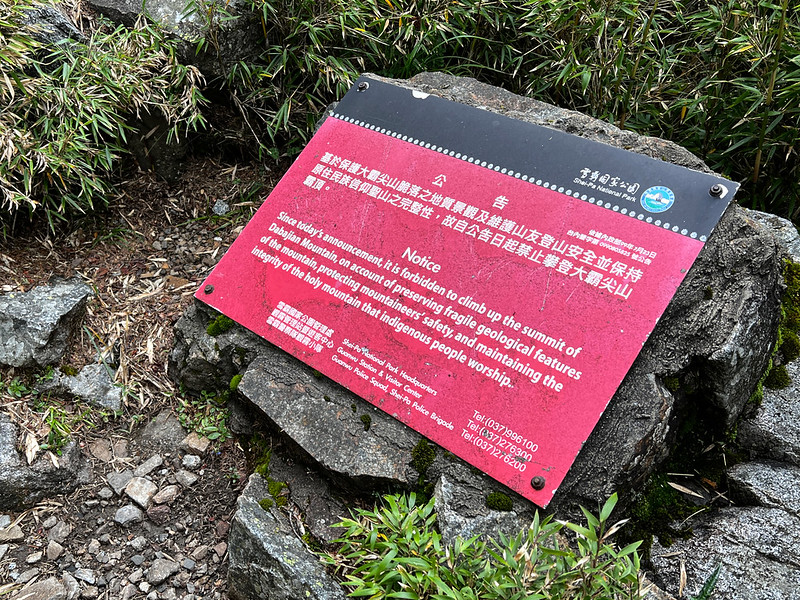
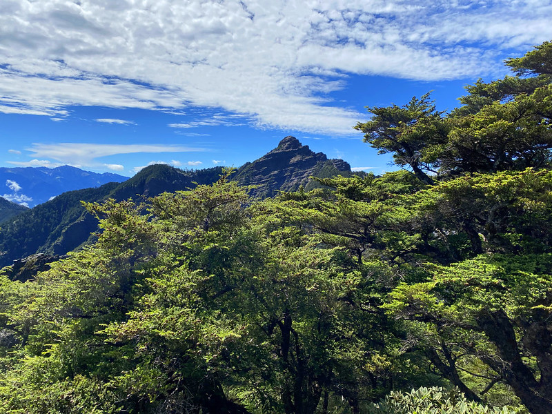
- 10. Mt. Dabajian 大霸尖山: 3,492 meters (11,456 feet), a Class 2 Triangulation Stone on the peak. It's not allowed to climb to the top. Hikers can only stay at the basal of the mountain. (100 Peaks)
- 11. Mt. Xiaobajian 小霸尖山: 3,418 meters (11,214 feet). (100 Peaks)
- 12. Mt. Yizhe 伊澤山: 3,297 meters (10,817 feet), a Class 3 Triangulation Stone on the peak. (100 Peaks)
- 13. Mt. Jiali 加利山: 3,112 meters (10,210 feet), a Class 3 Triangulation Stone on the peak. (100 Peaks)
Campsites and Cabins to Stay (Need to apply)
- 1. Sanliujiu Temporary Campsite or 369 Campsite 三六九臨時營地. Sanliujiu Cabin, 3,150 meters (10,334 feet), is under renovation, and the new cabin is scheduled to be finished in 2025. Now, Shei-Pa National Park provides a temporary campsite that accommodates 24 hikers. Yet, this campsite is only available for regular applications. The advanced applications can only apply for Qika Lodge.
- 2. Xuebei Cabin or Syuebei Cabin, 雪北山屋, 3,595 meters (11,794 feet), can accommodate 25 hikers. Phone signal is patchy. The water supply is not stable.
- 3. Sumida Cabin 素密達山屋, 3,485 meters (11,433 feet), can accommodate 24 hikers. Phone signal is patchy. The water supply is not stable.
- 4. Banan Cabin 霸南山屋, 3,105 meters (10,187 feet), can accommodate 15 hikers. Phone signal is not available. The water supply is not stable.
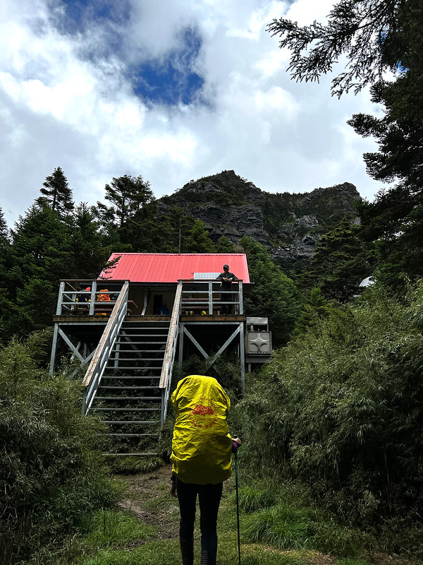
- 5. Jiujiu Cabin 九九山屋, 2,699 meters (8,855 feet). The Cabin accommodates up to 150 hikers with a fee of NT$200 per person per night. Amenities include bunk beds, a water supply, solar lighting (not for electronic devices charging), and toilets.
- 6. Zhongba Cabin or Jhongba Hut 中霸山屋, 3,295 meters (10,810 feet), can accommodate 12 hikers. Phone signal is good. The water supply is not stable. Some hikers will stay here if Bana Cabin is not available.

Additional Information about Safety:
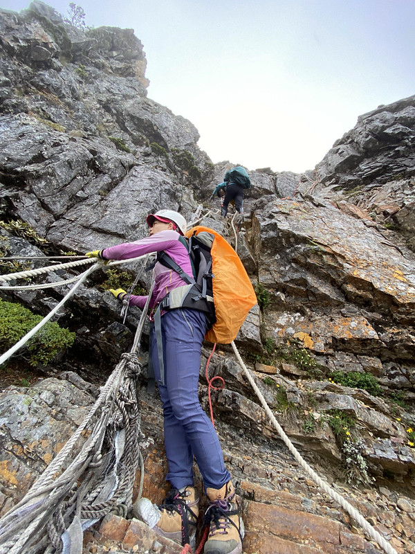
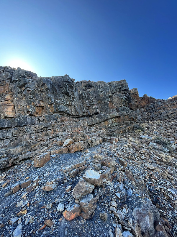
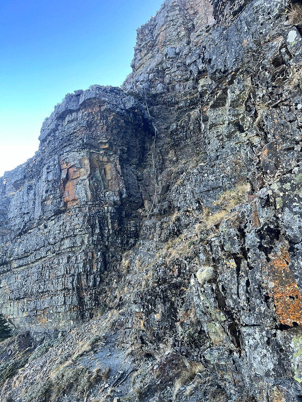
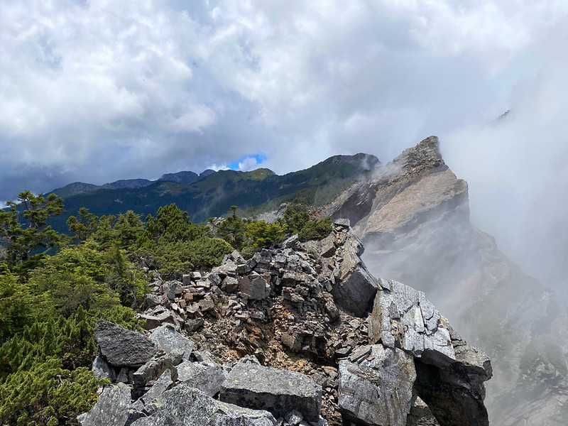
Sumida Cliff 素密達斷崖 is steep, with a near-vertical drop of 30-40 meters. Seeing the cliff might hinder some
hikers from proceeding. Hikers will find ropes and the famous/notorious ladder made by Shei-Pa National Park.
Hikers are advised to bring their own ropes just in case. It's recommended to drop down their backpacks first
for safety.
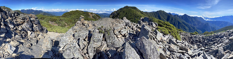
Expect rock scrambling and hiking on scree/talus slopes and knife ridges.

Cellphone signal is almost not available or patchy on the Holy Ridge trail. According to Shei-Pa National
Park, hikers can find some signal between Xuebei Cabin and Mt. Kailantekun Peak, the 2.5 km mark, Xueshan Main
Peak, the junction near Sanliujiu Cabin, and Mt. Yizhe, Jiujiu Cabin.
Please check Shei-Pa National Park Climbing Forums 雪霸國家公園登山資訊分享站
for the latest news before your hike.
Must-have Gear:
- A helmet.
- A pair of gloves when grabbing the ropes is helpful to prevent the rope burn or being scraped by the sharp rocks.
- Sun protection.
- Belaying:
Equipment for the group of fewer than 10 hikers for belaying: the essential gear for belaying includes webbing (at least 7 meters long and 25 mm wide), a rope with a diameter of 12 mm (3 inches) and 20 meters in length, slings, and 2 carabiners. Increase the amount of equipment mentioned above based on the size of your group.
Safety ropes and a ladder (dubbed as Shark Rostrum Sword 鯊魚劍) have been installed for climbing Sumida Cliff. When descending, hikers attach themselves with a large carabiner or a knot to the rope.
Please learn how to use those items before you do this hike.
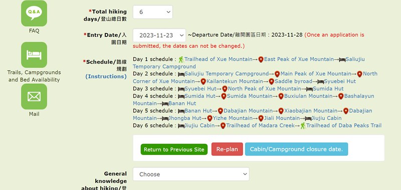
Brief Itinerary of the I Route:
Day 1: Xueshan Trailhead ➔ Qika Cabin ➔ Xueshan East Peak ➔ Sanliujiu Temporary
Campsite
Day 2: Sanliujiu Temporary Campsite ➔ Xueshan Main Peak ➔ Beilengjiao ➔ Mt.
Kailantekun ➔ Xuebei Cabin
Day 3: Xuebei Cabin ➔ Junction to Xueshan North Peak ➔ Xueshan North Peak ➔ Return
to junction to Xueshan North Peak ➔ Junction to Mt. Mutelebu ➔ Mt. Mutelebu (optional) ➔
Return to junction ➔ Sumida Cabin
Day 4: Sumida Cabin ➔ Sumida Cliffs and Mt. Sumida ➔ Mt. Buxiulan ➔ Mt. Bashalayun
➔ Bashalayun Cabin ➔ Banan Cabin
Day 5: Banan Cabin ➔ Mt. Dabajian ➔ Junction to Mt. Xiaobajian ➔ Mt. Xiaobajian
➔ Return to junction to Mt. Xiaobajian ➔ Junction to Mt. Yizhe ➔ Mt. Yizhe ➔ The
second entrance to Mt. Yizhe ➔ Junction to Mt. Jiali ➔ Jiujiu Cabin
Day 6: Jiujiu Cabin ➔ Mt. Dabajian checkpoint ➔ Guanwu Forest Recreation Area
GPX Track of the I Route
Route map for Holy Ridge Trail - I Route by Anusha Lee on plotaroute.com
Click Menu in the map to download, print, or share the map.
You can see more options after clicking the Play button.
Click to change the speed to meet your condition.
You can see more options after clicking the Play button.
Click
to change the speed to meet your condition.
Trail Information: Y Route, and Map/GPX
The Y Route is the longest one among all, and this route includes the famous Wuling Quadruple Mountains
Trail, which adds up to an extra four 100 peaks.
Distance: 69.9 km (43.4 miles)
Route type: Point-to-point between Taoshan Trailhead and Xueshan Trailhead
Days/Hours Needed: 7 days
Best Time to Go: Spring, summer and fall. Snow season usually starts from January to March. Please check National Park's website for the gear requirement.
Permits: The national park permits are required. The Police Mountain Entry Permits are no longer needed.
Difficulty Level:
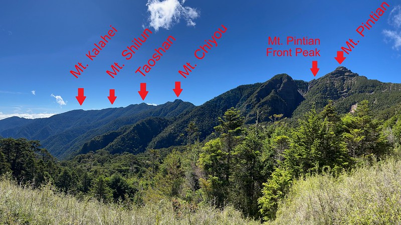
The Extra 4 Peaks to Hike:
- 1. Mt. Pintian 品田山, 3,524 meters (11,562 feet). Hikers must tackle the notorious Pintian V Cliff before reaching Mt. Pintian. The views are breathtaking from the top.
- 2. Mt. Chiyou 池有山, 3,303 meters (10,837 feet). There is a Class 3 Triangulation Stone on the top. The views are amazing, too.
- 3. Mt. Tao, aka Tao Mountain or Taoshan, 桃山, 3,325 meters (10,909 feet). If I can only choose one of Wuling Quadruple Mountains to hike, Taoshan is the one.
- 4. Mt. Kalahei 喀拉業山, 3,133 meters (10,279 feet). There is a Class 2 Triangulation Stone on the top. There is not much to see from the peak, but the views are great before reaching Mt. Kalahei.

Extra Cabins and Campsites to Stay (Permits Required):
- 1. Taoshan Cabin and Campsite 桃山山屋/營地, 3,725 meters (12,221 feet), can only accommodate 19 hikers and 3 tents. The water source relies on the tank to collect rain. Phone signal is stable.
- 2. Xinda Cabin and Campsite 新達山屋/營地, 3,175 meters (10,416 feet), can accommodate 34 hikers and 6 or 7 tents. There are water tanks and a small creek nearby.
- 3. Cui Pond Cabin/Campsite 翠池山屋/營地, 3,510 meters (11,516 feet), can accommodate 12 hikers and the campsite 20. The phone signal is not good. Hikers can draw water from Cui Pond and filter the water. Cui Pond is also the highest alpine lake in Taiwan.
- Note: Bashalayun Cabin was destroyed a long time ago and is not suitable for staying.

Additional Information about Safety:
Hikers will pass two types of Pintian cliffs: Pintian V Cliff and Pintian . The V one is easier
and shorter, while climbing or descending the Pintian Cliffs requires belaying equipment and technical skills.
Pintian Cliffs 品田斷崖 consists of three sections. The first section is a challenging 10-meter vertical
cliff with significant descending. This section is the shortest among all but also the most dangerous one.
The second one is a 15-meter face with more footholds.

The third one, a 70-degree, 30-meter slope, should be easier after the previous challenges.
The situation at Pintian Cliffs is a little different from Sumida Cliffs, especially when descending from Mt.
Buxiulan. The footholds are not visible, and the added weight of a heavy backpack can increase the risk. If the
hiker slips, the load's extra weight worsens gravity's force.
Therefore, some hikers lower down their backpacks first when descending. Having someone to belay and help you
find the footholds when descending is better.

If you think hiking 7 days is too long, skip Taoshan and Mt. Kalahei and start the hike to the Chiyou Trail to
Mt. Chiyou.
Must-have Gear:
Same as the items mentioned in the Y Route part.
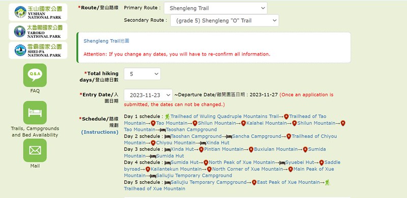
Brief Itinerary of the Y Route:
Day 1: Taoshan Trailhead ➔ Taoshan ➔ Taoshan Cabin/Campsite ➔ Taoshan ➔ Mt.
Shilun ➔ Mt. Kalahei ➔ Take the same trail back to Taoshan Cabin/Campsite
Day 2: Taoshan Cabin/Campsite ➔ Sancha Campsite/junction ➔ Junction to Mt. Chiyou ➔
Mt. Chiyou ➔ Return to junction ➔ Xinda Cabin/Campsite
Day 3: Xinda Cabin/Campsite ➔ Mt. Pintian V Cliff ➔ Mt. Pintian ➔ Mt. Pintian Cliffs
➔ Mt. Buxiulan ➔ Mt. Bashalayun ➔ Bashalayun Cabin ➔ Banan Cabin
Day 4: : Banan Cabin ➔ Junction to Mt. Xiaobajian ➔ Mt. Xiaobajian ➔ Return to
junction ➔ Mt. Yizhe ➔ Junction to Mt. Jiali ➔ Mt. Jiali ➔ Return to the junction
➔ Return to the junction to Mt. Xiaobajian ➔ Banan Cabin
Day 5: Banan Cabin ➔ Bashalayun Cabin ➔ Mt. Bashalayun ➔ Mt. Buxiulan ➔
Sumida Cliffs and Mt. Sumida ➔ Sumida Cabin
Day 6: Sumida Cabin ➔ Xueshan North Peak ➔ Xuebei Cabin ➔ Mt. Kailantekun North Peak
➔ Junction to Sanliujiu Cabin ➔ Mt. Kailantekun ➔ Beilengjiao ➔ Junction to Cui Pond
and Cui Cabin ➔ Cui Pond and Cui Cabin
Day 7: Cui Cabin ➔ Return to the junction ➔ Xueshan Main Peak ➔ Sanliujiu
Cabin/Temporary Campsite ➔ Xueshan East Peak ➔ Qika Cabin ➔ Xueshan Trailhead

GPX Track of the Y Route
Route map for Holy Ridge Trail - Y Route by Anusha Lee on plotaroute.com
Click Menu in the map to download, print, or share the map.
You can see more options after clicking the Play button.
Click to change the speed to meet your condition.
You can see more options after clicking the Play button.
Click
to change the speed to meet your condition.
Trail Information: "O" Route, and Map/GPX
Distance: 41.3 km (25.6 miles)
Route type: Point-to-point between Xueshan Trailhead and Wuling Quadruple Mountains Trail
Days/Hours Needed: 5 days
Best Time to Go: Spring, summer and fall. Snow season usually starts from January to March. Please check National Park's website for the gear requirement.
Permits: The national park permits are required. The Police Mountain Entry Permits are no longer needed.
Difficulty Level:
Peaks to Reach
- 1. Xueshan East Peak 雪山東峰
- 2. Xueshan Main Peak 雪山主峰
- 3. Beilengjiao 北稜角
- 4. Mt. Kailantekun 凱蘭特崑山
- 5. Xueshan, North Peak 雪山北峰
- 6. Mt. Mutelebu 穆特勒布山
- 7. Mt. Sumida 素密達山
- 8. Mt. Buxiulan 布秀蘭山
- 9. Mt. Bashalayun 巴紗拉雲山
- 10. Mt. Pintian 品田山
- 11. Mt. Chiyou 池有山
- 12. Taoshan, 桃山
- 13. Mt. Kalahei 喀拉業山
Campsites and Cabins to Stay (Need to apply)
- 1. Taoshan Cabin and Campsite 桃山山屋/營地
- 2. Xinda Cabin and Campsite 新達山屋/營地
- 3. Sumida Cabin 素密達山屋
- 1. Sanliujiu Temporary Campsite or 369 Campsite 三六九臨時營地
Additional Information:
Same as the I and Y Route.
Brief Itinerary of the O Route
Day 1: Taoshan Trailhead ➔ Taoshan ➔ Taoshan Cabin/Campsite ➔ Taoshan ➔ Mt.
Shilun ➔ Mt. Kalahei ➔ Take the same trail back to Taoshan Cabin/Campsite
Day 2: Taoshan Cabin/Campsite ➔ Sancha Campsite/junction ➔ Junction to Mt. Chiyou ➔
Mt. Chiyou ➔ Return to junction ➔ Xinda Cabin/Campsite
Day 3: Xinda Cabin/Campsite ➔ Pintian V Cliff ➔ Mt. Pintian ➔ Pintian Cliffs
➔ Mt. Buxiulan ➔ Sumida Cliffs and Mt. Sumida ➔ Sumida Cabin
Day 4: Sumida Cabin ➔ Junction to Xueshan North Peak ➔ Xueshan North Peak ➔ Return
to the junction ➔ Xuebei Cabin ➔ Mt. Kailantekun North Peak ➔ Junction to Sanliujiu Cabin
➔ Mt. Kailantekun ➔ Beilengjiao ➔ Xueshan Main Peak ➔ Sanliujiu Temporary
Campsite/Cabin
Day 5: Sanliujiu Temporary Campsite ➔ Xueshan East Peak ➔ Qika Cabin ➔ Xueshan
Trailhead

GPX Track of the O Route
Route map for Holy Ridge Trail - O Route by Anusha Lee on plotaroute.com
Click Menu in the map to download, print, or share the map.
You can see more options after clicking the Play button.
Click to change the speed to meet your condition.
You can see more options after clicking the Play button.
Click
to change the speed to meet your condition.
Holy Ridge Y Route in 4 Days - Only for Super Fit
Although doing the Holy Ridge is almost every hiker's dream, it's not for everyone. This hike involves technical
skills, physical strength, and the ability to cope with heights.
I tried this in August 2022 but didn't finish the whole hike. I have no regrets, but I also do not intend to try
again.
Typically, it takes at least 6 or 7 days to do this hike. My friend, Acer Lee, and his friends are trained
hiking guides who are very fit. They modified some sections to make this hike.

Acer's Y route didn't pass Pintian Cliffs.
Day 1: Wuling Villa/Wuling Suspension Bridge ➔ Junction to Taoshan ➔ Junction to Chiyou ➔ Mt. Chiyou ➔ Return to junction ➔ Xinda Cabin/Campsite ➔ Junction to Bashalayun Cabin ➔ Takejin Creek ➔ Banan Cabin
Estimated time: 12 hours
For the details from Wuling Villa to Mt. Chiyou and Xinda Cabin, you can read my Mt. Dabajian or Wuling
Quadruple Mountains Trail. In short, the section from Wuling Villa to Mt. Chiyou and Xinda Campsite/Junction is
steep and long, and the elevation gain is 1,419 meters.
Yet, the section from the junction near Xinda Cabin down to Takejin Creek source and up to the ruined Bashalayun
Cabin is worse than the previous one. Expect this kind of terrain for the rest of the hike.
Yet, the forests are beautiful, and you can see the whole ridgeline of the Wuling Quadruple Mountains.
When I did this section, going down from the elevation of 3,166 meters to the bottom of Takejin Creek (around
2,700 meters) on the treacherous terrain was hard. Later, we climbed the rock scrambles with a creek running
through the boulders.

Before reaching Banan Cabin, more rock scrambles await.
Day 2: Banan Cabin ➔ Junction to Mt. Xiaobajian ➔ Mt. Xiaobajian ➔ Return to junction ➔ Mt. Yizhe ➔ Junction to Mt. Jiali ➔ Mt. Jiali ➔ Return to the junction ➔ Return to the junction to Mt. Xiaobajian ➔ Banan Cabin
Estimated time: 13.5 hours
More rock scrambles await on the hike from Banan Cabin to the junction of Mt. Xiaobajian.

Here comes the "I LOVE U" sandstone flat 我愛你平台, which is wide and flat. Many hikers use rocks to form words,
such as "I LOV U" or dates they did this hike.
This section is close to the basal of Mt. Dabajian, and the vast bluff ahead is Mt. Dabajian. The smaller one on
the left is Mt. Xiaobajian.

Then, climbing through the narrow rock passage to the junction of Mt. Xiaobajian was difficult. If your backpack
gets stuck in the crack, you must use a rope to haul your backpack later.

After passing the gap, we saw a junction and a sign on the right warning hikers that climbing to the top of Mt.
Dabajian is not allowed and will receive a hefty fine. Climbing to the top of Mt. Dabajian has been forbidden
since 2010 by the Shei-Pa National Park.
Taking the left, you will walk around Mt. Dabajian and reach a junction that takes you to Mt. Xiaobajian. You
can read the details of my hike to Mt. Xiaobajian and Mt. Dabajian.
Then, Acer's group took the same way back to Banan Cabin after doing Mt. Xiaobajian, Mt. Dabajian, Mt. Jiali,
and Mt. Yizhe. Although they only carried the essential items to this section, it's still not easy.
Day 3: Banan Cabin ➔ Bashalayun Cabin ➔ Mt. Bashalayun ➔ Mt. Buxiulan ➔ Sumida Cliffs and Mt. Sumida ➔ Sumida Cabin ➔ Xuebei Cabin
Estimated time: 12.5 hours. Didn't go to Xueshan North Peak because it was already dark.
Day 3's hike is the most dangerous one of all. Being fit is not enough for this hike. Hikers also require mental
strength to deal with vertical cliffs and heights.
After passing the talus slopes from Banan Cabin, hikers must traverse more knife ridges. When I hiked high
mountains, one taxing task was going through the dwarf bamboo woods. Compared to the narrow ridges sharp like a
knife, those dwarf bamboo woods seem like a break.

Although hiking on the talus slopes and knife ridges is not for a fainted heart, the views from the ridge are
stunning.
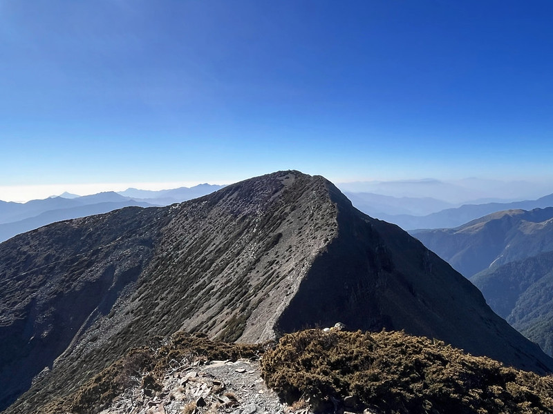
The view of Mt. Mutelebu from Mt. Bashalayun (around 9 km on the trail) is spectacular. This rugged and
distinctive appearance makes this mountain stand out from the distance. Hikers can hike to this mountain from
Sumida Cabin, and the round trip is about 1 hour.
One thing worth mentioning is three Taiwanese climbers, Tony Shaw 蕭添益, Hua-jun Hung 洪華駿, and Pai-wei Chou 周百威,
took a different route from the Da'an Creek source and scaled about 1,000 meters on the northeast side to the
top (3,623 meters/11,886 feet) from December 7 to 10, 2021. They named this route Trust.
You can see their feat in photos and details. Please
note that this route is technical climbing, not for everyone.
The view from Mt. Buxiulan is equally incredible, and Mt. Pintian's beddings are clear from here.
Then, here comes the beast, Sumida Cliffs. If hikers descend from the top, they must go through 3 folds:
vertical descending, semi-horizontal traversing, and climbing down the ladder, aka Shark Rostrum Sword 鯊魚劍.

This ladder was set up by Shei-Pa National Park in March 2020 for safety reasons. It looks like a religious
apparatus used in Taoism. Many hikers were unhappy about this decision because it looked hideous, and the
national park could have done a better job. Well, what's done is done.
If you think the rest of the trail would be easier, think again. What is waiting ahead is dangerous talus
slopes, up and down. The comforting part is the breathtaking views on both sides if the weather is good.

Day 4: Xuebei Cabin ➔ Mt. Kailantekun North Peak ➔ Junction to Sanliujiu Cabin ➔ Sanliujiu Cabin ➔ Xueshan East Peak ➔ Qika Cabin ➔ Xueshan Trailhead
Estimated time: 7.5 hours. Acer's group turned to Sanliujiu Cabin at the junction after Mt. Kailantekun North
Peak and headed to the trailhead. They also skipped Xueshan Main Peak and Beilengjiao.
It was already dark when Acer and his hiking mates reached Xuebei Cabin. So, they didn't go to Xueshan North
Peak. But they saw the extraordinary sunrise.

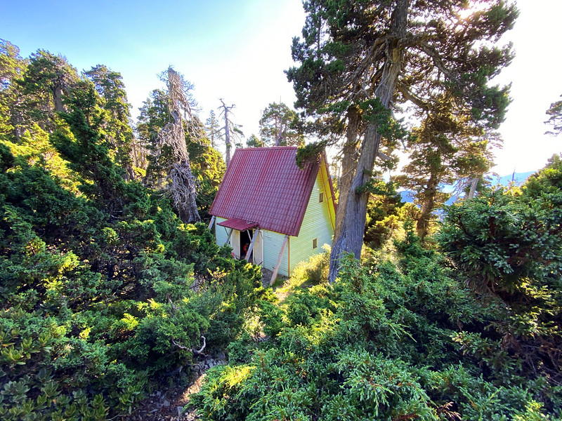
Xuebei Cabin, near the 4 km mark on the trail, is lovingly dubbed as the fairytale cottage on the trails in
Taiwan. This two-story building looks cute next to the tall Single-seed Juniper 玉山圓柏.
After reaching the ridge, there are is phone signal between the 4 km and 2.5 km millage signs, according to
hikers' reports. If the weather is good, you can see Sanliujiu Cabin from the 3 km mark.
Because Acer suffered minor high-altitude sickness, they didn't go to Xueshan Main Peak. They turned to
Sanliujiu Cabin at the junction after Mt. Kailantekun North Peak (around the 2 km mark).
The section from Beilengjiao to Xueshan Main Peak is mostly talus slopes. It becomes more dangerous if it rains.
Please watch this hiker's Beilengjiao hike before you go, especially
if you are new to the trails in Taiwan.

For details about the rest of the hike from Xueshan to the trailhead, please read my post about Xueshan Main Peak, East Peak, and Cui
Pond.
Hiking Permits, Transport, and Variations of Spellings on Shie-Pa National Park Website
How to Select the Routes When Applying for Hiking Permits
Second, click Online Application, read the rules, and check all required boxes. Then, click "I
Agree".
You can only select Standard Application if you want to hike Holy Ridge Trail, aka Shengleng Trail.
After selecting Shengleng Trail as your Primary Route, you have two options as your Secondary Route:
(grade 5) Shengleng Trail "I" Shape,
(grade 5) Shengleng Trail "O" Trail, and
(grade 5) Shengleng Trail "Y" Trail.
(grade 5) Shengleng Trail "I" Shape,
(grade 5) Shengleng Trail "O" Trail, and
(grade 5) Shengleng Trail "Y" Trail.
Each route has different trailheads. The routes are from the old application website, but you can still
use them as a reference.
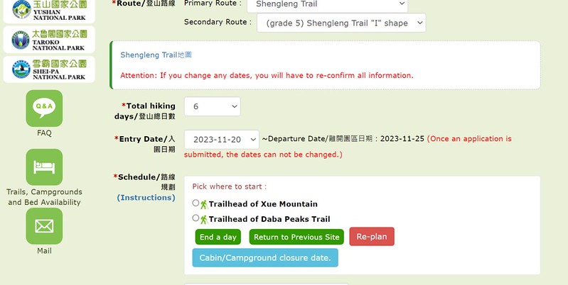
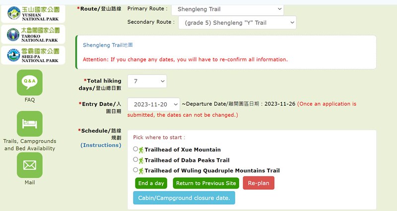

Here are the examples of the orders of those points on the trails. You can take those for reference when you
apply for the park permits.

After filling out the routes, follow the instructions to finish the application. You will receive an email about
your application. If you leave the phone number from other countries, you may receive another email from Shei-Pa
National Park to ensure you will turn on roaming when you arrive in Taiwan.
Public Transport to the Trailheads
To Xueshan Trailhead and Wuling Quadruple Mountains Trail at Wuling Farm 武陵農場:
Take Kuokang Bus 1751 from the Yilan Bus Station or Bus 1764 from Luodong Bus Station.
To Dabajian Checkpoint at Guanwu 觀霧山莊: Taiwan Tourist Shuttle Service - Guanwu
Route
Variations of the Names on Shei-Pa Nation Park's website
For hikers who don't read Chinese, the biggest hurdle to apply is selecting the routes. The second one is
variations of the spellings make the application process even more difficult.
Shei-Pa National Park: Shei means snow, and Pa is Ba in Chinese.
Shengleng Trail 聖稜線: Holy Ridge Trail
Xueshan 雪山: Mt. Xue, Xue Mountain, Mt. Suye, Suye Mountain
Xueshan North Peak 雪山北峰: North Peak of Mt. Xue (Syue)
Beilengjiao 北稜角: North Corner of Mt. Xue or Mt. Sue
Xuebei Cabin (Hut) 雪北山屋: Syuebei Cabin (Hut)
Cuei Pond 翠池: Cui Pond, Cui Chi, Cuei Chi
Junction at the saddle: Saddle byroad 鞍部叉路. I've never heard of “saddle byroad” before, nor have my native English-speaking friends. I guess Shei-Pa invented something new, and this took me a while to understand.
Mt. Dabajian 大霸尖山: Daba Peaks
Jhongba Hut 中霸山屋: Zhongba Cabin (Hut)
Mt. Yize 伊澤山 (江澤山): Mt. Yizhe, Mt. Jiangze
Jiujiu Cabin 九九山莊: 99 Cabin
Sanliujiu Cabin 三六九山莊: 369 Cabin
Taoshan 桃山: Mt. Tao
Mt. Kalahei 喀拉業山: Mt. Kalaye
Madala Creek 馬達拉溪: Madara Creek
Cabin or Hut, Campsite or Campground is interchangeable. I've lost track of which is which. You know what they
mean.