Syue Mountain (Mt. Snow): A Guide to Taiwan's Second-Highest Peak and the Hidden Gem of Cuei Pond
Syue Mountain, also known as Xueshan, Xue Mountain, Mt. Xue, or Snow Mountain, truly lives up to its name. In
winter, its snow-covered peak sometimes stands proudly in tropical Taiwan. Its striking beauty of vast glacier
cirques and challenging
terrain has charmed hikers worldwide, making it one of Taiwan's most sought-after high-altitude adventures.

In this guide, you'll find everything you need to plan a safe and successful Xue Mountain (Xueshan) hike —
from permit applications and route planning to transportation, accommodations, and essential tips for the
trail. For consistency, I'll use the name Xue Mountain, as on the official website.

Disclaimer:
All content is for inspiration only. Use Taiwan Hikes' suggestions at your own risk. We are not responsible for any losses, injuries, or damages.
All content is for inspiration only. Use Taiwan Hikes' suggestions at your own risk. We are not responsible for any losses, injuries, or damages.
Table of Contents:
- Trail Information: The Most Popular Route - Xue Mountain Main and East Peak
- Maps, How to Get There with Public Transportation, and Accommodation
- Easier Route: Details about Hiking Xue Mountain Main and East Peak
- Xue Mountain Alternative Itinerary: Qika Cabin to East Peak and Main Peak - For Super Fit Only
- Challenging Route: Hiking Further to Cuei Pond to Camp
- How to Apply for A Permit to Hike Xue Mountain and Snow Season Regulations
- About Xue Mountain (Xueshan) and Shei-Pa National Park
- Related Posts
Trail Information: The Most Popular Route - Xue Mountain Main and East Peak
Distance: 21.8 km (13.5 miles)
Route type: Out and back
Days/Hours Needed: 2 days (some hikers do this in one day)
Total Ascent/Descent: 1,718m/1,674m
Snow Season Requirements: This trail is good to hike in late spring, summber, and fall. The snow season often starts from mid-December/January to March. Shei-Pa National Park requires training and extra gear if you hike in the snow season.
Permits: Required
Additional Information: Before your hike, please check Shei-Pa National Park Climbing Forums 雪霸國家公園登山資訊分享站 to see if the trail is open or other things that you need to know.
Difficulty Level:
Peaks and Places to Reach
- Xue Mountain, Mt. Syue, Xueshan, Mt. Snow, or Mt. Sylvia Main Peak 雪山主峰, 3,886 meters (12,749 feet) above sea level.
- Xue Mountain East Peak, Xueshan East Peak 雪山東峰, 3,201 meters (10,502 feet) above sea level.
- Sanliujiu Temporary Campground 三六九臨時營地, 3,150 meters (10,335 feet) above sea level. Campground capacity: 24 people.
- Qika (Cika) Cabin and Campground 七卡山莊和營地, 2,460 meters (8,071 feet) above sea level. Cabin capacity: 106 people; campground capacity: 30 people.
Maps, How to Get There with Public Transportation, and Accommodation
Xue Mountain/Wuling Farm Bus Guide
Here's a flowchart about how you get to Wuling Farm or the trailhead.

You take Kuokuang Bus 1751 from Yilan Transfer Station, or Kuokuang Bus 1764 from Luodong Transfer Station,
and get off at Wuling Visitor Center. Taking Kuokuang Bus 1751 or 1764 is easier than bus 866.
Hire A Private Pickup
If you don't want to walk an extra of 11 km (0.7 miles) to the trailhead, you can stay at Wuling Hostel near Wuling Farm and hire their private pickup service to the
Xue Mountain trailhead. Contact Mr. Huang (Terry) WhatsApp +886 (0) 983328960 for details. You will also find
a
restaurant and a small shop where you can purchase cartridges, snacks, ramen, fuel cartridges, and other
items.

GPX Track
The following track includes hike to Cuei Pond.
Route map for Xueshan Main, East Peak And Cuei Pond 20240903 by Anusha Lee on plotaroute.com
Click Menu in the map to download, print, or share the map.
You can see more options after clicking the Play button.
Click to change the speed to meet your condition.
You can see more options after clicking the Play button.
Click
to change the speed to meet your condition.
Easier Route: Details about Hiking Xue Mountain Main and East Peak
You might be curious why we started early on Day 1 since the hike takes around 6 hours. The main reason is that
thunderstorms and torrential rains are typical in the mountains during the summer. Getting caught up in the rain
is not fun, and the good weather usually turns overcast around noon.
Day 1: Start the Hike from the Famous Water Reservoir near Xue Mountain Park Entry Permit Check-in Counter
06:30 We arrived at the Xue Mountain Park Entry Permit Check-in Counter
雪山登山口服務站,
2,140 meters above sea level. This checkpoint opens at 7:00, so we put our permits in the mailbox. You will find
toilets here.


06:42 After getting ready, we started our hike and passed the famous water
reservoir.

You will find a detailed map of the Shengleng Trail (Holy Ridge Trail) and posts of millage. The distance to
Qika (Cika) Cabin is 2 km, to Sanliujiu Hut is 7.1 km, and to Xue Mountain Main Peak is 10.9 km.

The first 2 km are easy to hike and paved with many stairs. It may seem a short hike, but doing this in one day
is very challenging. I've stated several times that the distance of the trails in Taiwan can mean
nothing.
We saw a small bridge above a track. The track was built to transport the materials for the new Sanliujiu Cabin.

07:38 We arrived at Qika Cabin or (Cika Hut) 七卡山莊, 2,460 meters above sea level.
If you stay here, please check in with the manager when you arrive.

Qika Cabin is big and can accommodate 106 hikers. It has bunk beds, a kitchen and dining area, flushed toilets,
and a drying room.
09:53 We reached the resting area before Ku Po (Ku Slope) at around 4 km and
took a 15-minute break to enjoy the views. Ku Po literally means Crying Slope in Chinese. So, you get the idea
about this section.


360-degree View from Xue Mountain East Peak
11:11 We reached the 5 km post, where the first junction to Xue Mountain East
Peak,
3,201 meters, which could be seen from the junction, too.

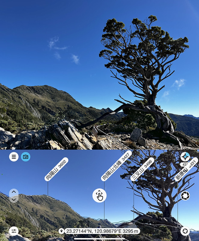
The views from Xue Mountain East Peak were fantastic, and we were surrounded by Xue Mountain Main Peak,
Beilengjiao, the
Holy Ridge, Mt. Dabajian, Wuling Quadruple Mountains, and other 100 Peaks.


Our destination, Sanliujiu (369) Temporary Campground, seemed close to Xue Mountain East Peak, but, in fact, it
wasn't. The circled area on the top of the photo is the construction work for the new Sanliujiu Cabin. The one
on the bottom is the temporary campground.
After passing the helipad next to Xue Mountain East Peak, we entered the woods again, and the trail was up and
down.
Sanliujiu Temporary Campground
12:34 We reached the junction of the old Sanliujiu Cabin.

12:52 Getting to the Sanliujiu Temporary Campground was taxing because we had to
go up and downhill again, which descended about 200 meters. Seeing your destination but not being able to call
it a day sooner tested my willpower. Finally, we arrived.

When you arrive, remember your permit's plank number listed on the permit. Each plank has a number, and most
hikers hire the on-site
catering service. You might be able to switch the plank.


There are toilets, a kitchen area, and water tanks to draw water.

We had to go to the woods near the toilets facing east to get one or two bars of phone signals, but the view
here was worth the extra walk.

Day 2: From Sanliujiu Campground to Taiwan White Fir Forest
At first, we planned to see the sunrise from Xue Mountain Main Peak. However, reaching the summit from the
campground
took at least 3 to 4 hours, and we had to get up around 1 am to catch the sunlight. So, we decided to sleep
longer and woke up at 4 am to prepare.
05:07 We left the campground when the sun was rising from the clouds. We stopped
before entering the black forest to see the dazzling colors above the clouds.

05:59 We entered the forests at around 7.9 km and were amazed by the Taiwan
White Fir 台灣冷杉. It's Taiwan White Fir, but we call this forest Black Forest 黑森林 in Taiwan. My hiking mate was
from Oregon, United States, and he said the forests looked like what they have in Oregon.

06:53 At 8.9 km, we reached a post with signs pointing to Mt. Syue, Water, and
Sanliujiu Hut. This place may look like a great camping spot, but wild camping is prohibited.


The Xueshan Cirques
07:52 We reached the cirque at 9.8 km. This place was vast. I've seen Xue
Mountain
from a distance for years and finally arrived here in person.

When we reached the 9.9 km post, the trail cutting into the cirques was blocked. We took the trail on the left
instead.

When I approached the summit, clouds flowed over the cirque and the summit. I was concerned that I would miss
the great weather.

Stunning Sunrise and Looking at Holy Ridge and Turtle Island from Xue Mountain Main Peak
09:31 Finally, I reached Xue Mountain Main Peak, 3,886 meters above
sea level. The clouds did threaten to take over the blue sky, but the strong winds pushed them aside.

The Holy Ridge and layers of mountains in the distance were like playing hide-and-seek. I also saw the famous Mt. Dabajian.


When the clouds cleared up slightly from the ocean in the east, Turtle Island, around 90 km (56 miles) away,
appeared.

Please note that you must get up around 1 a.m. if you want to see the sunrise from Xue Mountain Main Peak. The
hike
to the summit takes at least 3 to 4 hours.

Return to the Trailhead and Check Out
If you only hike to the summit, you can hike light with essential gear from the Sanliujiu Temporary Campground,
return to the campground, and then hike back to the trailhead. It takes around 6-8 hours from the summit to the
trailhead, depending on your pace.
When you arrive at the trailhead, remember to go to the Xue Mountain Park Entry Permit Check-in Counter again to
check out.
Xue Mountain Alternative Itinerary: Qika Cabin to East Peak and Main Peak - For Super Fit Only
The Sanliujiu Lodge was initially scheduled for completion in 2026, but due to ongoing disputes between Shei-Pa
National Park and the contractors, the project has been postponed indefinitely.
For now, only 24 spots are available at the Sanliujiu Temporary Campground, and there are no advanced
applications available for international hikers. If you are strong, experienced, and desperately want to hike
Taiwan's second-highest mountain, a great alternative is to stay at Qika Cabin on Day 1.

Qika Cabin offers 24 beds through the advanced reservation system from Thursday to Monday, but advanced
applications are not open on weekends or national holidays.

This is a demanding itinerary. After finishing the long descent, you may not be able to walk to the Wuling
Visitor Center bus stop in time for the last bus. I recommend arranging a pickup from Wuling Hostel and staying
an extra night to fully rest and recover.
Check the "How to Apply for A Permit" section for details.
Challenging Route: Hiking Further to Cuei Pond to Camp
The Highest Alpine Lake in Taiwan: Cuei Pond, also spelled as Cui or Ts'ui Pond
Distance: 25 km (15.5 miles)
Route type: Out and back
Days/Hours Needed: Pond: 3 days
Total Ascent/Descent: 2,456m/2,459m
Permits: Required. Check permit appliction section.
Difficulty Level:
Route type: Out and back
Days/Hours Needed: Pond: 3 days
Total Ascent/Descent: 2,456m/2,459m
Permits: Required. Check permit appliction section.
Difficulty Level:

This is a three-day hike and you need to apply for Cuei Pond Hut or Cuei Campground on your Day 2.
If you hike further to Cuei Pond like us, remember the following sections are more challenging and not suitable
for people who don't like heights.
Continue from our hike to Xue Mountain Main Peak. Before we left the Xue
Mountain Main
Peak, a Formosan serow suddenly appeared at a cliff. I've seldom seen so many Formosan serows in one hike, and
their poops are almost everywhere on the trail. They are not afraid of humans at all. I hope it's because they
are getting used to being fed by hikers.

The following section from the Xue Mountain Main Peak to the junction of Cuei Pond and Beilengjiao is steep, and
the
trail is narrow. It felt like I could easily fall to my death if I lost my footing.

I became very nervous and intense and decided to give up climbing Beilengjiao. My hiking mate went there with
the other two hikers we met. The round trip takes about one hour.

Exhaustion overtook me while waiting for my hiking mate to return, and I almost dozed off. This junction was not
a good place to doze off, though.

Steep Rock/Sand Scrambles to Cuei Pond
11:54 My hiking mate returned safely and continued our descent to Cuei Pond.
While clouds began forming in the Xue Mountain cirques, the clouds and fog were thicker in the valley on the
opposite
side.

If the section between the Xue Mountain Main Peak and the junction to Cuei Pond was horrible, this rock-scramble
slope was even worse. Most sections were gravels and rocks, and I couldn't find footing. I kept sliding and was
scared.

My hiking mate strode down quickly and effortlessly while I struggled and slid on the rock scrambles. He later
shared his technique for dealing with gravels sand and rocks: He first loosened the backpack's load stabilizers
to shift the gravity further. Then, he first hit the gravel slope with his heel to increase friction and prevent
himself from sliding.
Our Hike to Cuei Pond
12:46 After what felt like forever, I finally finished the steep slope and went
into a flatter rock scramble area. More tall, beautiful forests appeared, and we reached the forest of
Single-seed Juniper 玉山圓柏.

Unlike the short and crooked Single-seed Junipers scattering in the Xue Mountain cirques, these were thick,
tall, and
straight. The valley had shielded them from the relentless wind and harsh weather.
13:02 Finally, I reached Cuei Pond Hut, and my hiking mate had been waiting for
me for a while. If you stay at the Cuei Pond Hut, you must walk further to reach the front door.

Only 4 hikers were staying by Cuei Pond that day. We found a quiet place to pitch our tents. Be aware of small
wild animals stealing your food. We saw several around our tents.


My First Slope Ascending Faster than Descending
Usually, descending will be faster than ascending. Yet, our return to the junction took around 90 minutes, while
it took me more than 2 hours to descend. The scary rock scrambles really got me.
Yet, the section from the junction back to Xue Mountain Main Peak was still scary, even though I couldn't see
the
vast cirque in the dark.
How to Apply for A Permit to Hike Xue Mountain and Snow Season Regulations
Advanced Applications Are Only Available at Qika Cabin.
If you want to stay at Sanliujiu (369) Temporary Campground, you can only go through the regular application.
Please remember to send your application to Hike Smart Taiwan Service 臺灣登山申請一站式服務網 between 7:00 -
23:00 (GMT+8).


Itinerary you need for your hike, staying at Sanliujiu Temporary Campground:
Day 1: Trailhead of Xue Mountain ➔ Qika Cabin ➔ East Peak of Xue Mountain ➔ Sanliujiu Temporary Campground Temporary Campground
Day 2: Sanliujiu Temporary Campground ➔ Main Peak of Xue Mountain ➔ Sanliujiu Temporary Campground ➔ East Peak of Xue Mountain ➔ Trailhead of Xue Mountain
Day 1: Trailhead of Xue Mountain ➔ Qika Cabin ➔ East Peak of Xue Mountain ➔ Sanliujiu Temporary Campground Temporary Campground
Day 2: Sanliujiu Temporary Campground ➔ Main Peak of Xue Mountain ➔ Sanliujiu Temporary Campground ➔ East Peak of Xue Mountain ➔ Trailhead of Xue Mountain
Itinerary you need for your hike, staying at Qika Cabin:
Day 1: Your location ➔ Wuling Farm ➔ Xue Mountain Trailhead (check-in) ➔ Qika Cabin
Day 2: Qika Cabin ➔ East Peak of Xue Mountain ➔ Junction to Sanliujiu Temporary Campground ➔ Black Forest ➔ Main Peak of Xue Mountain ➔ Return the same way to the Trailhead of Xue Mountain
Day 1: Your location ➔ Wuling Farm ➔ Xue Mountain Trailhead (check-in) ➔ Qika Cabin
Day 2: Qika Cabin ➔ East Peak of Xue Mountain ➔ Junction to Sanliujiu Temporary Campground ➔ Black Forest ➔ Main Peak of Xue Mountain ➔ Return the same way to the Trailhead of Xue Mountain
Please do your homework before you hike those popular trails. Several local governments have specific
regulations for activities in mountain areas. Please read the post Essential Guide to Hiking Regulations in Taiwan to avoid
unnecessary hefty fines.
Gear for Snow Season
The snow season is usually between mid-December/January and March. Shei-Park National Park has requirements for hikers during snow season.
The gear list from Shei-Pa National Park during snow season: a helmet, hiking boots and crampons (at least 10
points), gaiters, an ice axe, a headlamp, snow goggles, warm & waterproof clothing, wool socks, waterproof
gloves, and other essentials.

About the Names of Snow Mountain (Xueshan) and Shei-Pa National Park
Xueshan might be the mountain that owns the most different names in Taiwan. Here's a brief list of where those
names came from, according to a hiking database website, Hiking Biji.
From the Indigenous Atayal People
The Snow Mountain region has been a hunting ground for the indigenous Atayal people, who have various names for
it.
Babo Hagai 巴布哈蓋山 or Hagai 哈蓋山 is used by the Atayal people living on the eastern slopes of Snow Mountain. "Babo"
means big mountain, and "Hagai" refers to snow collapses (I assume they refer to avalanches.)
In the Atayal language, Snow Mountain is also known as "Mahamayan 馬哈馬顏山," which can be translated as "Mahamayan
Mountain."
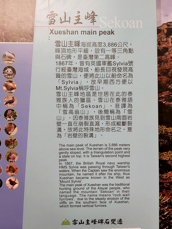
On the western slopes of Snow Mountain, the Atayal people of the Beishi tribe 北勢部族泰雅族 call it "Sekoan," meaning
"rock wall furrows." It's phonetically translated as "Xuegaoweng" and later simplified to "Xueweng Mountain" or
"Snow Mountain."

From the Qing Dynasty
In 1893, during the reign of Emperor Guangxu, Shen Maoyin, the governor of Miaoli at the time, depicted Snow
Mountain as the fifth of "Eight Scenic Views of Miaoli" by writing "Yu Shan Ji Xue 玉山霽雪," literally meaning
glistening snow that made the mountain look like jade. The Jade Mountain here refers to Snow Mountain or
Xue Mountain, not Yushan.
From the British Captain
In 1867, while passing through Taiwan's waters, the British warship HMS Sylvia reportedly spotted the towering
Snow Mountain. The ship's captain named the mountain "Sylvia." In early Western literature, it was referred to
as Mt. Sylvia.
From the Japanese Colonial Period
During the Japanese colonial period in Taiwan in 1915, surveyors, including Hisakatsu Toshitsune 財津久平,
successfully reached the summit of Snow Mountain's main peak via the eastern ridge of the East Peak. They
measured its height as 12,972 feet, discovering it was taller than Japan's Mount Fuji.
In 1923, Prince Hirohito (Emperor Showa) visited Taiwan and named Snow Mountain the "Second Highest Mountain in
Taiwan 次高山" just after Mount Jade (Yushan, the New Highest Mountain). The long-gone Second Highest Shrine was
established at the summit, with a shrine gate and torii.
About Cuei Pond:
According to the National Park Service Ministry of the
Interior website, Cuei Pond is a tarn, a small mountain lake or pond, typically found nestled in a steep,
bowl-shaped area formed by glaciers called a cirque.
The width of Cuei Pond is less than 30 meters (98 feet), and sitting by the pond is a lovely escape for hikers.
Hikers who visited Cuei Pond before July 2021 would see a small earth god temple, the highest one in Taiwan, by
the side of the highest alpine lake, Cuei Pond. However, Shei-Pa National Park relocated this temple
to a lower altitude in fear of possible forest fire.

You will see the fantastic Single-seed Juniper 玉山圓柏 around here. Those stunning trees are largely distributed in
the alpine tundra more than 3,400 meters above sea level. They are a major member of the dwarf shrub that grows
above the timberline and are extremely important to soil and water conservation.
When striving to adapt to a harsh natural environment, some that grow on the slopes exposed to the cutting winds
shape in various postures at high mountains, like the famous one near Mt. Xiangyang.
About Cuei Pond Hut/Campsite 翠池山屋/營地
With an elevation of 3,510 meters (11,516 feet), Cuei Pond Hut can accommodate 12 hikers and the campsite 20.
The phone signal is not good. Hikers can draw water from Cuei Pond and filter the water.
The phone reception is not good here. I had to take the same trail to a higher slope to send text messages, but
my hiking mate had 2 bars near the Cuei Pond toilets.
Other More Challenging Routes - Jhihjiayang (Zhijiayang) Xueshan Route 志佳陽雪山線
In 1915, during the Japanese era, a survey team led by Kazuhiro Izutsu 財津久平 ventured from Pyanan Village (now
Nanshan Village 南山村) through the Puyuma Saddle (now Siyuan Saddle 思源啞口), Chi Jia Yang Village (now Sqoyaw or
Huanshan Village 環山部落) to Mt. Zhijiayang (3,345 meters/10,974 feet) and finished the survey.
Since then, this route became a major one to explore Xue Mountain till the 1970s. The new route replaced this
route,
the current Xue Mountain Major and East Peak route, in the 1970s. Some hikers still take the Jhihjiayang Route
to
enjoy the rugged terrain and stunning landscape.
This route takes at least 3 days.

Other More Challenging Routes - Holy Ridge (Shengleng) Trail Route
In 1927, the renowned Japanese mountaineer Numai Tetsutaro 沼井鐵太郎 made the first ascent of the majestic Dabajian
Mountain in Taiwan. As he stood on the summit, gazing southward at the winding, dragon-like ridge that stretched
all the way to the pinnacle of Xue Mountain, he couldn't help but exclaim, "This holy ridge! Who can truly
complete
the traverse from Dabajian to Xue Mountain, don the crown of victory, and narrate the genuine beauty of this
first-ever achievement?"

Three years later, he fulfilled his dream by conquering this Holy Ridge, and the name Holy Ridge or Sheng Leng in Chinese has endured ever
since.

Holy Ridgeline Trail has 3 routes: Y
Route, I Route, and O Route (loop), ranging from 5 to 9 days. There are several strenuous sections. Those
routes are only for very seasoned and fit hikers. I love solo hikes, but I don't recommend doing solo hikes on
the Holy Ridge.