Yushan Front Peak: Steep Rock Climbing with Breathtaking Views
Yushan (Jade Mountain) is Taiwan's top choice for high-mountain hiking, but its popularity makes getting a
permit harder than the hike itself. Yushan (Jade Mountain) Front Peak is a great alternative, offering
splendid views and a steep rock scramble.

Although the distance from the junction to Yushan Front Peak is only 800 meters (0.49 miles), reaching the
summit can take more than 1 hour. With its stunning views, Yushan Front Peak is a great stand-alone hike or an
addition to your Yushan adventure in Taiwan.

Disclaimer:
All content is for inspiration only. Use Taiwan Hikes' suggestions at your own risk. We are not responsible for any losses, injuries, or damages.
All content is for inspiration only. Use Taiwan Hikes' suggestions at your own risk. We are not responsible for any losses, injuries, or damages.
Table of Contents:
Trail Information
Trail Name: Yushan/Mt. Jade Front Peak 玉山前峰
Distance: 7 km (4.3 miles)
Route type: Out and back
Days/Hours Needed: 4-6 hours
Total Ascent/Descent: 719 m/719 m
Best Time to Go: All seasons, but there will be special requirements during the snow season.
Permits: National Park Permit and Poice Mountain Entry Permit are required.
Difficulty Level:
Peaks or Places to Reach
- Yushan Front Peak or Jade Mountain Front Peak 玉山前峰, 3,239 meters (10,626 feet), listed as No. 71 on the 100 Peaks in Taiwan.
Other Ways to Do Yushan Front Peak:
- You can arrange a two-day hike and stay in the comfort of a hotel: on Day 1, hike Tataka Three Mountains (Mt. Lulin, Mt. Lulin Front Peak, and Mt. Linzhi), and on Day 2, hike Yushan Front Peak.
- Hike Yushan Front Peak and Tataka Three Mountains in a day. This itinerary will be a more challenging hike.
- If you plan to hike Yushan Main Peak, you can put Yushan Front Peak on Day 1 when you apply for the permits.
Additional Information:
- Phone receptions are mostly good on the trail.
- Wearing a helmet is advised.

2026 Yushan Permit Application Guide
The hardest part of Yushan isn't the climb — it's the permit. My 2026 Yushan permit application guide walks you through the government site screen by screen, so you don't lose a date to a missed checkbox.
How to Apply for Permits to Hike Yushan Front Peak
When to Apply and How Many Spots Are Available Each Day?
When: 5 days to 2 months before the day you want to hike.
How many people can apply for the hike: 100 per day.
Click "Yushan 1 Day Route" to see the many hiking spots available.
How many people can apply for the hike: 100 per day.
Click "Yushan 1 Day Route" to see the many hiking spots available.
Application Process
Go to Hike Smart Taiwan Service website, click "Online Application", and then "Apply for Park Permit."

Click "Yushan National Park Headquarters" and then click "Search." You will see "Yushan Front Peak Day Hike
(Tataka - Yushan Front Peak - Tataka)", and then click "entry application."

Read the content and check all the boxes required. Then, click "I Agree."

If you want to hike Yushan Front Peak, please check the box of Standard Application. Then, click "Next."

Fill out the required information. The new website will display your Yushan Front Peak route and send the
Police Permit (Police Department Mountain Pass Application shown on the website) for you. Click "Next."

Fill out the required form, follow the instructions, and then send it out. You will receive your application
number. You need this number to check your application progress and results and download the park permit five
days before your hike.

When you are granted the permit, don't be shocked if you receive many emails from the national park that look
like they are spamming you.

Maps, Transportation, and Accommodations
GPX Track From
Click Menu in the map to download, print, or share the map.
You can see more options after clicking the Play button.
Click to change the speed to meet your condition.
You can see more options after clicking the Play button.
Click
to change the speed to meet your condition.
From Your Location to Tataka Trailhead

Public Transport: from Chiayi to Alishan
No matter where you are in Taiwan, you go to Taiwan High Speed Rail (THSR) Chiayi Station to take Taiwan Tourist Shuttle Bus, Alishan Route.
Take Alishan Route 7329 From Taiwan High Speed Rail Chiayi Station to Alishan Transport Station 阿里山轉運站. The bus
fare for one trip is NT$278.
Public Transport: from Alishan Transport Station to Upper Dongpu
Take Yuanlin Bus 6739 員林客運 6739 from Alishan Transport Station 阿里山轉運站 at 14:00. Get off at Shangdongpu Stop 上東埔站,
and then walk to Dongpu Lodge. The bus fare for one trip is NT$68.
Because of Covid, Yuanlin Bus has reduced the bus schedules. For the latest schedule, please check Yuanlin Bus 員林客運 website for updates.
From Paiyun Mountaineering Center to Tataka Trailhead
The shuttle bus is in front of Paiyun Mounteering Service Center. Each shuttle can be seated up to 7 hikers. The
fare is NT$150 per person from 6:30 to 17:00. It's NT$200 between 17:00 and 19:00, and you need to make a call to
arrange the pickup.

If you need a pickup after 19:00, please call Dongpu Lodge in advance to see the fare and time.
If you don't mind, you can hike another 2.4 km to Paiyun Mountaineering Center from Tataka trailhead.
Driving to Shangdongpu Parking Lot
Click the map of Shangdongpu Parking Lot. If you drive from Shuili, Nantou, please check
the traffic control before you go. The section between 110 and 145k of the Taiwan
Provincial Highway 21 台21線 is closed from 17:30 pm to 7:00 the next day.
Accommodations
Dongpu Lodge
is the only hostel near the Paiyun Mountaineering Service Center, and the altitude is high enough to acclimatize.
Dongpu Lodge offers bunk beds for NT$400 per person per night. Dongpu Lodge is 2,580 meters above sea level.

Another option is to stay at Wangxiang Village before the hike. The drive from Wangxiang Village to Shangdongpu
Parking Lot takes around one hour. We often stay at Xiaosong Kalibuan Village, which also provides a porter and pickup service.
Wangxiang Village is 850 meters above sea level.

Details of This Hike
Brief itinerary: Check in at Paiyun Mountaineering Service Center and take the shuttle bus ➔
Tataka Trailhead (0 km, 2,610 m) ➔ Menglu (Monroe) Pavilion (1.7 km, 2,838 m) ➔ Junction to Yushan
Front Peak (2.7 km, 2,860 m) ➔ Yushan Front Peak (3.5 km, 3,233 m) ➔ Junction ➔ Menglu
(Monroe) Pavilion ➔ Tataka Trailhead ➔ Paiyun Mountaineering Service Center
We stayed at Wangxiang Village the night before the hike. It took us around 1 hour to drive from our hotel to
Shangdongpu Parking Lot.

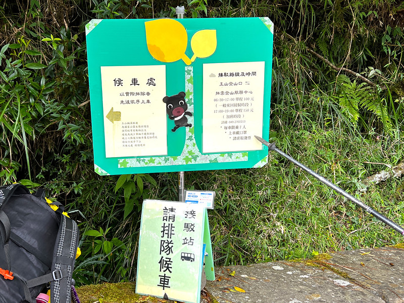
07:58 From the Shangdongpu Parking Lot, we headed to the Paiyun Mountaineering
Service Center. After checking in, we queued for the shuttle bus.

08:16 We arrived at Tataka Trailhead. We spent some time taking photos here.

08:30 We started our hike.
Important: The first 500-meter section was prone to falling rocks long before the magnitude 6.2
earthquake hit Taiwan on April 3, 2024. One hiker was even struck to death when he hiked here,
and several reported injuries. Therefore, wearing a helmet is a must.
While on the Yushan trail, we saw many metal bridges like this. If you take a closer look, each bridge is
numbered. There are 82 bridges in total before reaching Paiyun Lodge.

08:45 I reached the 0.5 km marker, which also says the distance from here to
Paiyun Lodge is 8 km away.

09:23 I reached Menglu (Monroe) Pavilion and took a short break.

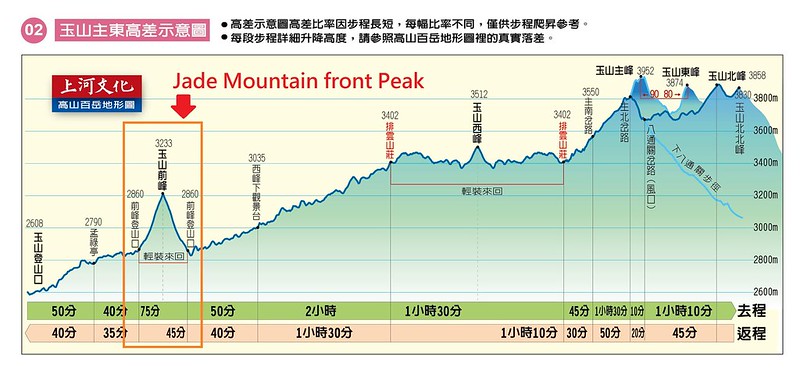
10:12 We reached the junction to Yushan Front Peak.

The signage says the distance from this junction to Yushan Front Peak is 800 meters/0.49 miles, but this section
took me 100 minutes to ascend and 72 minutes to return. In addition to the steep and strenuous terrain, my
hiking mates, who made me take more photos than I liked, were another reason for my slowness.
10:37 Our guide, Kevin, stopped here to show us the rock profile. It did look
like a gorilla's profile. What do you think?

10:45 We reached the badass hiking section to Yushan Front Peak, where the rock
scrambles start.

If you ask me, this rock scramble section is steeper and scarier than those to Mt. Baigu. I didn't wear a
helmet for this hike, but I will if I do this hike again.
Climbing this rock scramble section is daunting. It felt like rock climbing, and some boulders became loose when
I stepped on them.

Yet, the rewards were the stunning views when I looked back to catch my breath. The pyramid-shaped Guanshan or
Mt. Guan (3,668 meters/12,034 feet), layers of mountain ridges, and the crispy blue sky.

11:51 I finally reached Yushan Front Peak.

There isn't an ample place at the summit, and the scorching sun made me hide in the bushes for a lunch break,
but seeing the Yushan mountains from here still excited me.

Since Yushan Front Peak is also listed in the 100 Peaks (100 Baiyue) in Taiwan, bagging this summit is popular
among hikers. More and more hikers were coming, so we left right after the 30-minute lunch break.
Climbing up to the Yushan Front Peak summit is challenging, but descending isn't easy, either. The gaps among
those boulders were significant, and some boulders were wobbly. Again, please proceed with extra caution.

13:34 We were back at the junction.
14:27 We were back at Menlu Pavilion.
15:05 I reached Tataka Trailhead and queued for the shuttle bus. If you do this
hike or hike to other Yushan peaks, remember to check out online after you finish the
hike.
Ready to hike Yushan?
Skip the scattered, half-outdated blog posts. The 2026 Yushan Permit &
Hiking Guide walks you through the permit application screen by screen, plus
transport, lodges, gear, timing, and the one-day option — all in English,
all current. Built from 10 summits.
About Yushan/Mt. Jade Front Peak and Trails Nearby
First Ascent Record of Yushan Front Peak
In April 1900, the first recorded ascent of Yushan Front Peak was made by Torii Ryūzō, Mori Ushinosuke, and
others during an academic exploration via the Alishan route.

Origin of Monroe (Menglu) Pavilion 孟祿亭
In June 1951, J.E. Monroe arrived in Taiwan to work as a tax consultant for the U.S. Mutual Security Agency's
China Division. In October 1952, he tragically fell to his death while descending from Yushan, resulting in the
area being named "Monroe (Menglu) Cliff 孟祿斷崖" — the first post-war foreign fatality on Yushan.
A memorial stone was erected at the site to commemorate his contributions to Taiwan's economy. Due to the
cliff's inaccessibility, a new path was created, and Monroe Pavilion, or Menglu Pavilion, was built in his
memory.

The pavilion at the boundary between temperate and frigid forests is the first landmark hikers encounter from
the Tataka trailhead. It serves as a resting spot and has toilets nearby.

Your Time-Saver Guide to Yushan: The Complete Hiking Checklist
Planning your Yushan hike doesn't have to involve hours of searching through confusing information. This
time-saving checklist includes everything you need in one convenient place: permit timelines, recommended
start times, weather tips, gear lists, safety notes, and more.
Based on my experience summiting Yushan eight times, this guide is designed to help you plan more effectively,
avoid common mistakes, and focus on enjoying your hike. Download the checklist now and start preparing with
confidence. Or click the image below.