Yushan: The Ultimate Hiking Guide to Taiwan's Highest Mountain, Unveiling Routes from Easy to Epic!
Jade Mountain, or Yushan, standing tall at 3,952 meters, is a dream destination for adventurers from across
the globe. This picturesque wonder graces the NT$1,000 banknote and has become many people's bucket list
because of her breathtaking beauty.

This comprehensive guide provides everything you need to embark on your unforgettable journey up Jade
Mountain. Find out how to apply for permits, arrange seamless transportation, and learn all the essential
details you need to know.
More importantly, you'll learn how to avoid critical mistakes that affect safety, preparedness, and your
ability to return home safely.

Table of Contents:
- How Do Yushan Hike Permits and Paiyun Lodge Work?
- Mt. Jade Main Peak Route – The Classic and Most Popular Trail, Including Doing Yushan in A Day
- Mt. Jade West Peak - Home to the Highest Shrine in Taiwan
- Mt. Jade North Peak - The Best Viewpoint of the Main Peak
- Mt. Jade East Peak - A True Challenge for Those Without Fear of Heights
- The Batongguan Historic Trail - The Most Demanding Route to Yushan and Too Dangerous Now
- Dangerous Mistakes to Avoid on the Jade Mountain Hike
- How to Use the Hike Smart Taiwan Service to Apply for Hiking Permits
- How to Get There - Transportation, Paiyun Lodge, and Sleeping Bag Rental and Catering at Paiyun Lodge
- Your Time-Saver Guide to Yushan: The Complete Hiking Checklist
- Related Posts
How Do Yushan Hike Permits and Paiyun Lodge Work?
The Standard Hike is Two days, One night.
You don't summit and come down in one go. You hike up to Paiyun Lodge (3,402 m) on Day One and sleep there. Then climb to the Yushan Main Peak (3,952 m) for sunrise on day two and walk all the way back down.
Your Permit and Your Bed Are the Same Thing.
When your Paiyun Lodge application is approved, that is your permit — there's no separate booking for the bed: no bed, no permit, no hike.
The park entry permit and the police permit are free; the things you pay for are the lodge fee and catering (sleeping bag rental and meals). Please note that the sleeping bag rental and meals are run by a private company, not the Yushan National Park. That's why you check in at two different counters at Paiyun Lodge.
The Bottleneck Is Space at Paiyun, Not the Trail.
The hike is hard but doable for a fit person. Getting a spot is the part people lose sleep over. That's what the application section is for.
You Acclimatize the Night Before the Hike, and Dongpu Lodge Is the Closest and Only Available Hostel.
There Is Also A One-day Option - Only for Fit and Seasoned Hikers.
Strong, experienced hikers can do Yushan in a single day without staying at Paiyun. It's a different permit choice in the system and a much bigger day (10–16 hours). If this is your first 3,000 m+ peak, do the two-day hike. The one-day option is not available during the snow season. This option also requires the park permit and the police permit.

Yushan Peaks I've Hiked:
- Yushan Main Peak – climbed 10 times, including 7 one-day hikes.
- Yushan North Peak – 3 times
- Yushan N. North Peak – 1 time
- Yushan East Peak – 1 time
- Yushan Front Peak – 2 times
2026 Yushan Permit Application Guide
The hardest part of Yushan isn't the climb — it's the permit. My 2026 Yushan permit application guide walks you through the government site screen by screen, so you don't lose a date to a missed checkbox.
Mt. Jade Main Peak Route – The Classic and Most Popular Trail, Including Doing Yushan in A Day
Mt. Jade (Yushan) Main Peak Trail Information
Distance: 21.8 km (13.5 miles)
Route type: Out and back
Days/Hours Needed: One or two days, depending on your fitness.
Total Ascent/Descent: 1,342 m/1,342 m
Best Time to Go: All year round, but you need snow gear and a training certificate if you want to hike between December and March.
Permits: Required
Difficulty Level for 2-day Hike:

Mt. Jade (Yushan) Main Peak Details
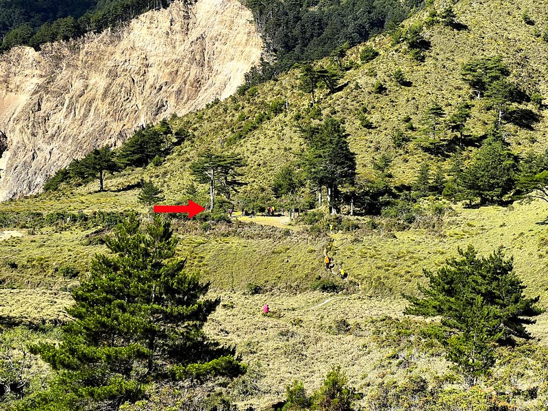
Brief itinerary: Tataka Saddle/Trailhead (0 km, 2,608m) ➔ Monroe Pavilion with toilets 孟祿亭 (1.7
km, 2,790m) ➔ junction to Jade Mountain Front Peak (2.3 km, 2,860m) ➔ White-wood Forest
(Baimulin) Observation Deck with toilets 白木林觀景區 (5.1 km) ➔ the Great Precipice 大峭壁 (3,187m) ➔
junction to Jade Mountain West Peak and Paiyun Lodge (8.5 km, 3,402m) ➔ Jade Mountain Main Peak (10.9
km, 3,952m)
Then, you take the same way back to Tataka Saddle (Anbu).
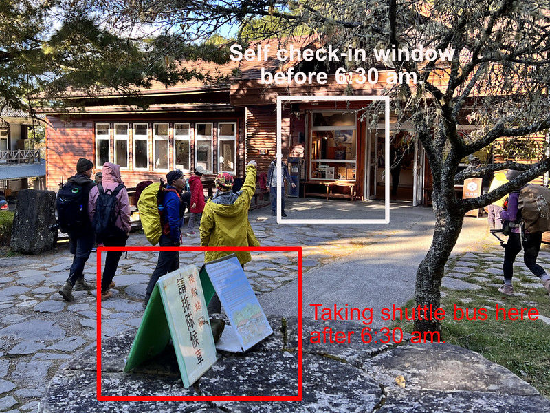
How to Check In at the Police Squad and Paiyun Mountaineering Center and Check Out After Hike
Bring your ID/passport and put your Police Mountain Entry Permit in the box at the Tataka Police Squad. It's
fine if you don't have the printouts, but make sure you have applied for the police permit. You can apply for
the police permit on the spot.

Then, go to Paiyun Mountaineering Center and check in with the staffer during office hours (6:30 to 17:00).
They will scan your ID/passport.
If you plan to hike Yushan Main Peak in a day and start before 6:30, international hikers check in when they
arrive at Paiyun Lodge.

Day 1: Hike to Paiyun Lodge from Tataka Saddle/Trailhead (Approximately 4-6 Hours)

If you are new to the trails and mountains in Taiwan, this route might be more challenging than you thought.
Some sections of trail terrains are rough rocks. The weather may turn cloudy around noon. Therefore, start
your hike as early as possible.
Alert: Falling Rocks!
Several hikers were struck by the falling rocks between 400 and 500 meters right after the trailhead. One
even fell to his death. Wearing a helmet is a must.
You'll pass Monroe Pavilion (aka Menglu Pavilion) 孟祿亭 soon. This pavilion was built to commemorate an American
tax consultant who fell to death on a deadly slope. You can also find bio-toilets here.

When you see the junction to Jade
Mountain Front Peak (Yushan Front Peak) with the sign saying it takes 0.8 km to reach the peak, please
don't be fooled by the numbers.

Before reaching White-wood Forest Observation Deck (aka Baimulin West Peak Observation Deck 西峰下觀景台), you will
pass bio-toilets with an address plate.

Then you can take a break at the observation deck to enjoy the Jade Mountain ridgeline.


Be aware of falling rocks at the Great Precipice, aka Daciaobi 大峭壁, 3,187 meters above sea level. A long,
long, long time ago, this place was at the bottom of a shallow sea. Long story short, tectonic movements
pushed it up and made it what it is now.

After passing the Great Precipice for around 10 minutes, you will see this spot.

This location is a great spot for taking photos. GPS coordinates: 120.942102, 23.465120
Then, Paiyun Lodge at 8.5 km. If you do this hike in two days, you can enjoy your break here.


Day 2: Hike to Mt. Jade Main Peak from Paiyun Lodge (Approximately 2–3 Hours)
Most hikers ascend to Main Peak around 3 or 3:30 am to see the sunrise at Mt. Jade Main Peak. So, you either
get your breakfast at 2 or 2:30 am. Remember to bring a headlamp and a pair of gloves with you.
The terrain and steepness become more treacherous after the junction to Yuanfong Cabin.

The rest of the trail is zigzagged, and the elevation gain may make breathing more difficult. Before reaching
Xiaofongkou 小風口, hikers have to pass through the cage. In March 2025, huge boulders fell, smashing the cage
and making passing through more difficult.


When hikers reach Xiaofongkou, they must put on more clothing. The wind is strong here all year round. If you
have reached this far, you have 300 meters before reaching Yushan (Jade Mountain) Main Peak.


Spectacular Views from Mt. Jade Main Peak
I finally saw the breathtaking views at the highest point of Taiwan.


It's time to descend, but it's not an easy task. Some hikers have fallen to their deaths here, so being extra
cautious is essential.

Yushan One Day Route: Doing Jade Mountain in A Day 玉山單攻 + Extra 2.4 km
Because of the scarcity of beds and the difficulty of applying to Paiyun Lodge, many hikers do this route in
one day.
However, doing Jade Mountain in one day isn't as easy as we thought. Other than physical fitness, those are
the regulations hikers need to consider before doing it in one day.

Moreover, be aware of the high-altitude sickness. The high-altitude sickness can happen to seasoned or new
hikers, no matter how fit you are. If you still want to try it in one day, please prepare for at least 12 to
16 hours.
I suffered from minor high-altitude sickness when hiking in Yushan in April 2025. With 700 meters left to
Yushan Main Peak, I decided to return to Paiyun Lodge. It wasn't an easy decision, but I'm glad I made the
right call.

Ready to hike Yushan?
Skip the scattered, half-outdated blog posts. The 2026 Yushan Permit &
Hiking Guide walks you through the permit application screen by screen, plus
transport, lodges, gear, timing, and the one-day option — all in English,
all current. Built from 10 summits.
Mt. Jade West Peak - Home to the Highest Shrine in Taiwan
Some hikers will also put Mt. Jade West Peak in their itinerary. The junction is right next to Paiyun Lodge.
The round trip to Mt. Jade West Peak and back to Paiyun Lodge is 2.5 to 3 hours.

I haven't done this hike yet, and this one is relatively easy to hike.

Mt. Jade North Peak - The Best Viewpoint of the Main Peak
The iconic view of Mt. Jade Main Peak is often captured from the weather station near Mt. Jade North Peak.
However, reaching this spot is no easy feat.


The trail is strenuous and can be dangerous due to steep, unstable scree slopes.

I've tackled these slopes 2.5 times, 3 ascents and 2 descents, and can say this hike isn't for everyone. My
round trip from the junction near Mt. Jade Main Peak took 4 hours in December 2024. In April 2025, it took me
5.5 hours, likely due to altitude sickness that hit me at North Peak and made the return much harder.

The route is straightforward: descend to the saddle, climb up to North Peak, and return the same way. Be
cautious at the Batongguan junction near the saddle—don't take the wrong turn. After reaching the saddle, the
terrain becomes gentler, with a sign explaining Mt. Jade's geography.


In May, you might catch the stunning rhododendron blossoms. I only saw buds when I did this hike in mid-April.

Standing at the weather station, reflecting on the journey, I felt both accomplished and daunted at the
thought of climbing back.

As you re-enter the forest and begin to ascend again, the trail becomes less defined but still easy to follow.
The final stretch to the weather station is exhausting—most hikers, including myself, were constantly out of
breath. Seeing the solar panels at last felt like a victory.

The weather station, Taiwan's highest building, isn't the summit. The true North Peak lies just behind,
accessed via a path on the right.

When I first arrived at 2 pm, Mt. Jade was silhouetted against the sun, with clouds rolling over the ridge—a
breathtaking scene.

Leaving wasn't easy—partly because of the stunning view, but mostly because of the challenging scree slopes
waiting on the way back.


Mt. Jade East Peak - A True Challenge for Those Without Fear of Heights
Hiking to Yushan East Peak is not suitable for everyone. I completed both the Main Peak and East Peak in one day, and by the end, I was utterly exhausted.

The terrain is fragile and full of scree slopes, making the descent even scarier, especially when passing the Phoenix Tail Rock (Feng Wei Rock) 鳳尾岩.

If it's rainy or icy during your hike, PLEASE DO NOT hike Yushan East Peak. It's too dangerous.
The last section to East Peak is like rock climbing. I felt okay while ascending, but descending was a different story.

The most rewarding aspect is the 360-degree view from the summit of Yushan East Peak.

The Batongguan Historic Trail - The Most Demanding Route to Yushan and Too Dangerous Now
Don't Recommend Hikers to Take This Route Now
Distance: 49.5 - 54.4 km (30.8 - 33.8 miles)
Route type: Point-to-point or out-and-back
Days/Hours Needed: At least 3 days
Total Ascent/Descent: 4,303m/2,973m (point-to-point route), or 3,620m/3,620m (out-and-back route)
Permits: Required
Difficulty Level:
Route type: Point-to-point or out-and-back
Days/Hours Needed: At least 3 days
Total Ascent/Descent: 4,303m/2,973m (point-to-point route), or 3,620m/3,620m (out-and-back route)
Permits: Required
Difficulty Level:
About Batongguan Historic Trail and Batongguan Traversing Trail
To prevent this post from becoming too long, I only mention the links you might be interested to read. You can
click here to learn more about Batongguan Ancient Trail or Batongguan
Historic Trail.
There is another trail called the Batongguan Traversing Trail 八通關越嶺步道. This one is more advanced and takes at
least 8 days to finish in one go. However, this one doesn't go to Jade Mountain. You can check out the Yushan National Park's website to see the difference between those two
trails
Dangerous Mistakes to Avoid on the Jade Mountain Hike
Assuming You Can Rent or Buy Gear Near Yushan
This is a critical planning mistake. There are NO gear rental shops in Alishan or Tataka, and once you arrive,
there is no backup option. If you reach the area missing essential equipment, your only safe choice is to
cancel the hike.
There are also NO grocery stores near the Yushan trailhead or checkpoint. Food, water, batteries, and
last-minute supplies are not available on-site. Everything you need must be prepared in Taipei or another
major city in advance.
By the time you board the bus to Alishan or Tataka, your gear, food, and emergency supplies should already
be fully packed and checked. Do not assume you can "figure it out later." On Yushan, poor planning
cannot be fixed at the trailhead—and attempting the hike without proper preparation puts both you and others
at risk.
Attempting the Yushan Day Hike Without Adequate Fitness Is a Serious Risk
Due to the limited availability of spots at Paiyun Lodge, many hikers—especially international visitors—choose
to attempt Yushan as a one-day hike. However, I have encountered hikers whose only preparation was running on
a treadmill a few times a week. This approach is reckless.
A one-day Yushan hike is not sightseeing or a casual endurance challenge. It involves long distances at high
altitude, rugged terrain, steep elevation gain, cold temperatures, and rapidly changing weather.
Attempting it without proper mountain-specific training significantly increases the risk of exhaustion,
altitude sickness, injury, and forced turn-backs—or worse.

Starting the Hike Too Late
The distance from the trailhead to Paiyun Lodge is 8.5 km (5.3 miles). It may sound short, but in Taiwan's
mountains, distance alone can be misleading. It says little about the terrain, which matters far more than the
distance.
I've seen hikers start far too late and end up hiking in complete darkness. Some international hikers don't
even have local phone numbers, leaving Paiyun Lodge staff unable to confirm their safety when they fail to
arrive on time.
Starting late also increases your exposure to summer afternoon thunderstorms, which are common in high
mountains. Instead of a controlled ascent, you may find yourself hiking in heavy rain, wind, or poor
visibility—conditions that significantly increase risk.
Attempting Yushan Without Essential Gear Is Reckless
If you plan to hike Yushan in a single day and do not have essential gear, especially a headlamp, you
should cancel the hike immediately. This is non-negotiable. There is nowhere to rent equipment on the
mountain, and improvising is not an option.
Without proper gear, you are not only putting yourself at serious risk but also endangering rescuers who may
be forced to respond in dangerous conditions. Essential items like a headlamp, warm layers, rain protection,
and emergency supplies are not optional add-ons—they are basic safety requirements.

Underestimating the Cold on Yushan
This warning is especially for hikers from cold-temperate climates. Taiwan may be known as a tropical country,
but that assumption becomes dangerous in the high mountains. On Yushan, it's entirely possible to experience
three seasons in a single hike.
Several sections of the trail are exposed, and under the sun, it can feel deceptively warm. But conditions
change rapidly as you gain elevation. Near the junction of Yushan Main Peak and North Peak, temperatures can
drop sharply. Strong, persistent winds strip away body heat, creating a real risk of hypothermia—especially
before sunrise.
Another factor many visitors underestimate is humidity. Cold in Taiwan is often wet, not dry. Wind combined
with moisture makes you feel colder than the temperature alone suggests, drastically reducing your margin for
error.
I've seen international hikers wearing shorts and light layers shivering uncontrollably in the final 300
meters to Yushan Main Peak before dawn—an entirely avoidable situation with proper insulation and wind
protection.

Ignoring Altitude Symptoms
Altitude sickness can cause headaches, nausea, dizziness, and fatigue. Ignoring these symptoms by continuing
to push forward without rest, hydration, or descending can be dangerous. It's important to listen to your body
and not hesitate to turn back.
Packing Too Much—or the Wrong Things
Overpacking leads to unnecessary fatigue, while underpacking leaves you unprepared when conditions change. On
Yushan, both mistakes can quickly turn a manageable hike into a serious safety issue. Your pack should include
essentials such as sufficient water, high-energy food, a headlamp, rain gear, warm layers, and basic emergency
supplies—nothing more, nothing less.
A well-fitted, lightweight backpack makes a significant difference over long distances and steep terrain.
One critical mistake to avoid is wearing jeans. While hiking may feel casual in some countries, denim performs
poorly in mountain environments. It absorbs moisture, dries slowly, and provides little insulation when
wet—conditions common on Yushan that can quickly increase the risk of hypothermia and fatigue.
How to Use the Hike Smart Taiwan Service to Apply for Hiking Permits
Please remember to send your application to Hike Smart Taiwan Service 臺灣登山申請一站式服務網 between 7:00
- 23:00 (GMT+8).

The most confusing part might be figuring out the itinerary on the application website. Here is the one for
your reference.

The Emergency Coordinator plays a crucial role in your hike. They must know your route well and know your
whereabouts during your hike. Make sure your emergency coordinator knows your hiking schedule and route well.

If you are coming from another country and need to pay the fee to obtain your hiking permit, you can save time by checking in the day before your hike. Visit the Paiyun Mountaineering Service Center to pay the fee during its office hours.
How to Get There - Transportation, Paiyun Lodge, and Sleeping Bag Rental and Catering at Paiyun Lodge
Dongpu Lodge and Amenties
If you only do Jade Mountain Main Peak and want to stay at the closest hotel, Dongpu Lodge 東埔山莊 is your only choice.
It's near the police station, the bus stop, and Tataka Visitor Center. It is NT$500 per person per night after
January 2025.

Dongpu Lodge takes the order 30 days before your hike. This place is not easy to book, either.
The beds at Dongpu Lodge are bunkbeds with curtains to keep your privacy. However, it can be noisy because
hikers come and go all day long.
If you are a light sleeper or prefer more privacy, staying at the hotels at Alishan, Jiayi County, or
Wangxiang Village, Nantou County, is an option. But those two options are suitable if you drive or hire a
driver.
Amenties at Dongpu Lodge:
There are two shower rooms, toilets, outlets for charging electronic devices, hot drinking water, a kitchen, and toilets. You can store things you don't want to bring to the hike at Dongpu Lodge.
There are two shower rooms, toilets, outlets for charging electronic devices, hot drinking water, a kitchen, and toilets. You can store things you don't want to bring to the hike at Dongpu Lodge.

Dongpu Lodge doesn't provide meals.
Dongpu Lodge check-in time: after 15:30; check-out: before 8:00 the next day. If hikers arrive at Dongpu Lodge
before 15:30, hikers have to wait till the staff opens the door. Dongpu Lodge turns off the light after 20:30.


Stop by Tataka Visitor Center for a Break
You can stop by the Tataka Visitor Center for a break before checking in at Dongpu Lodge. You can find the only restaurant in the Tataka area.

The visitor center is a perfect place to relax, learn more about Yushan, and recharge before your adventure.

Tataka Visitor Center and the restaurant close on the second Tuesday of each month.
Catering Service and Sleeping Bag Rental at Paiyun Lodge
After February 6, 2026, Dongpu Lodge's owner took over the catering service and sleeping bag rental. Please click their website page to order. You can use Google Translate to read the page in English.

At Paiyun Lodge, there are two front desks. Upon entering, the desk on the right is for Yushan National Park, where you can check in with your permit. The desk on the left is where you can obtain meal coupons and a sleeping bag after 3 p.m.


Public Transport: from Chiayi to Alishan
No matter where you are in Taiwan, you go to Taiwan High Speed Rail (THSR) Chiayi Station to take Taiwan
Tourist Shuttle Bus, Alishan A Route (7329). Or go to Taiwan Railway Chiayi Station to take Taiwan Tourist
Shuttle Bus, Alishan B Route (7322).
Public Transport: from Alishan Transport Station to Upper Dongpu (Shangdongpu)
Take Yuanlin Bus 6739 員林客運 6739 from Alishan Transport Station 阿里山轉運站. Get off at Shangdongpu Stop 上東埔站, and
then walk to Dongpu Lodge. Now we need to book the 6739's ticket and pay the bus fare in
advance.


Note:
- I booked the tickets in January 2026, but there were no options to select a bus stop for boarding. The bus company advised me to queue at the Alishan Transfer Station and inform the driver that I would be getting off at the Shangdongpu Stop. There is no need to book the ticket in advance for this. However, if you are coming from the Sun Moon Lake stop, you will need to book your ticket to receive the boarding QR code.
- Please note that there is no shop at the Alishan Transfer Station. However, there are shops located inside the Alishan National Forest Recreation Area, which requires an admission fee for entry.
From Paiyun Mountaineering Center to Tataka Trailhead
The shuttle bus is in front of Paiyun Mountaineering Service Center. Each shuttle can be seated up to 7
hikers. The fare has raised to NT$150 per person from 6:30 to 17:00 after November 2025.

If you need a pickup after 19:00, please call Dongpu Lodge in advance to see the fare and time. Or You can
hike another 2.8 km to Paiyun Mountaineering Center from the trailhead.
Driving to Shangdongpu Parking Lot
If you drive from Shuili, Nantou, please check the traffic control before you go. The
section between 110 and 145k of the Taiwan Provincial Highway 21 台21線 is closed from 17:30 pm to 7:00 the next
day.