Mt. Yuan to Daxi: A Ridgeline Hike between Sanxia and Daxi Old Streets
This is a very relaxing and beautiful ridgeline trail between Sanxia and Daxi. You can start this hike from
either side and enjoy Sanxia Old Street afterward. And guess what? There is a pleasant surprise on the trail
if you look closer.


Table of Contents:
- About Mt. Yuan Long Distance Trail and Taipei Skyline Trail
- How to Get There
- Peaks and Places to Reach
- Watching Ridgelines on the Way to Mt. Yuan
- A Detour to Beautiful Cliff Wall and Mt. Wushifen
- Enjoy My Solo Hike Again to Mt. Wutuku and Mt. Niangzhikeng
- Thoughts about This Hike
- Map and Itinerary
- Recommended Blogs and Resources
- Related Posts on Taiwan Hikes
About Mt. Yuan Long Distance Trail and Taipei Skyline Trail 環大台北天際線
This is an easy trail that lets you start from one of the famous old streets Sanxia Old Street 三峽老街, and ends near another one, Daxi Old Street 大溪老街, in northern Taiwan. You basically hike on the ridgeline
among several mountain peaks. When the weather is good, you get to see the beautiful mountains and Taoyuan
Tableland.

This trail is also part of the section 9 of
Taipei Skyline Trail 環大台北天際線. The total length of Taipei Skyline Trail is 250 km
(155 miles), and this idea was brought up by a famous hiker and author, Mr. Fusen Huang 黃福森, who has over 40
years of hiking experience, in 2016. This skyline trail connects 12 popular trails, and hikers can choose the
ones they like to hike.
There are many lists of trails in Taiwan, like 100 Peaks, Xiao Baiyue 小百岳 (Little 100 Peaks), Tamsui-Kavalan
Historical Trails, Taipei Skyline Trail, etc., and they are extremely popular in the local hiking communities.
Some hikers will pursuit finishing some or even all of them. Those are personal preference. Choose the trails
you like.
How to Get There
- 1) Take Bus 908 at MRT Jingan Station and get off at Sanxia Elementary School Stop 三峽國小站
- 2) Take Bus 910 at MRT Xinpu Station and get off at Sanxia Elementary School Stop 三峽國小站
- 3) Take Bus 916 at MRT Yongning Station and get off at Sanxia Elementary School Stop 三峽國小站
- 4) Take Taoyuan Bus 9103 either from Daxi or Sanxia and get off at Miaofa Temple 妙法寺
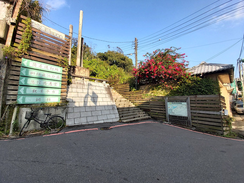
If you start from the Sanxia side, you go through Sanxia Old Street and you head to Nanran Park (Indigo Dyeing Park) 藍染公園. You'll see the
trailhead with a big map.
If you start from the Miaofa Temple, you need to get to the entrance of the trail from Miaofa Temple side at
24.8977806, 121.3074073.
Peaks and Places to Reach
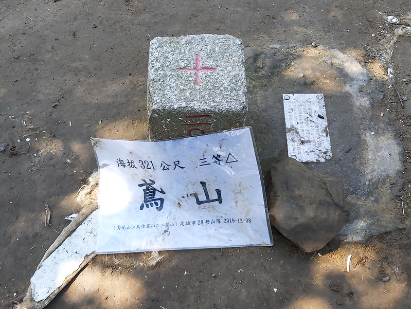
Mt. Yuan: 鳶山, also called Mt. Fudekeng 福德坑山, 321 meters (1,053 feet). There's
a Class 3 Triangulation Stone on the peak.
Mt. Wushifen: 五十分山, 296 meters (972 feet)
Mt. Wutuku: 烏塗窟山, 283 meters (928 feet)
Mt. Niangzhikeng: 娘子坑山, 238 meters (781 feet), no view
Sanxia Colorful Cliff Wall: 三峽彩壁, a beautiful cliff wall with different orange colors and becomes popular in the past few years.
Mt. Wushifen: 五十分山, 296 meters (972 feet)
Mt. Wutuku: 烏塗窟山, 283 meters (928 feet)
Mt. Niangzhikeng: 娘子坑山, 238 meters (781 feet), no view
Sanxia Colorful Cliff Wall: 三峽彩壁, a beautiful cliff wall with different orange colors and becomes popular in the past few years.
Watching Ridgelines on the Way to Mt. Yuan
GPS coordinates of Mt. Yuan: 24.93332, 121.36842
GPS coordinates of Miaofa Temple: 24.8941316, 121.3088729
GPS coordinates of the entrance to the trail from Miaofa Temple side: 24.8977806, 121.3074073
GPS coordinates of Miaofa Temple: 24.8941316, 121.3088729
GPS coordinates of the entrance to the trail from Miaofa Temple side: 24.8977806, 121.3074073
Starting from the Unusually Quiet Sanxia Old Street
After getting off bus, I went through Sanxia Old Street to Nanran Park (Indigo Dyeing Park) 藍染公園, a cute tiny
park to get myself ready. I went across the road and found the trailhead. I walked on Yuanfeng Road 鳶鋒路 for a
while to Yuanshan Memorial Bell 鳶山大鐘 and started the real trail.
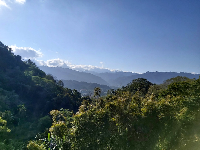
While walking on Yuanfeng Road, the layers mountains from Mt. Xue Range kept me company.
There was a pavilion close to Tzuhui Temple 慈惠堂. It would be so relaxing to have a cup of your favorite drink
to enjoy the mountain views there.

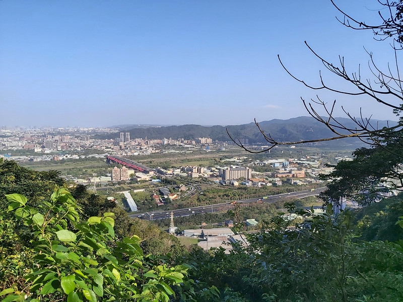
Then, I reached another pavilion on my right side, and I stopped there for a few minutes to overlook the
highway and Taoyuan.
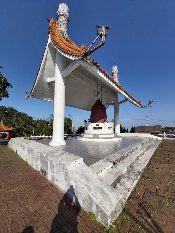
It didn't take long for me to reach Yuanshan Memorial Bell 光復紀念鐘 at Yuanshan Park. This bell was built to
celebrate the 40th anniversary of Taiwan being liberated from Japanese Occupation. There was a public toilet
if you have to go before your hike.
An Annoying and Unwelcome Tag Along (Warning: A Rant)
It wasn't difficult to find the entrance. There was a big sign telling you where you were. When I got there,
there was already a small group of hikers. I figured I might get stuck behind them if I continued, so I found
a place to sit and finished my breakfast, which turned out to be a mistake.

While I was having my breakfast, a short guy who seemed to be a few years older than me approached me out of
nowhere and asked me whether I saw a big group of hikers. I replied no. He then proceeded to explain to me how
he was late and missed the group. While I was wondering why he needed to explain his being late to me, he
asked me again: where are you going? As seemingly nice as I could, I replied. Then, he caught me off guard:
I'll go with you.

I was like, what the heck? I didn't say you could go hiking with me. You didn't even bother to ask for my
permission. He was ruining my solo hike. I could feel my heart was cringing, but you can tell he wasn't a
seasoned hiker from his equipment, even though he was kind like bragging that he had been hiking for almost 30
years.

This kind of hikers is very common in Taiwan. There are so many hiking groups and hikers really don't have to
learn how to read maps, navigate or even bring stoves. Furthermore, many hikers who have finished the 100
peaks still don't know how to read maps or pitch tents. They hire on-site catering service for meals, tents,
sleeping bags. Porters will arrive at the campsites or cabins in advance to get things ready. Those hikers
probably can't carry much in their backpacks.

However, there are also hikers who carry everything on their own. They study the trails and have well-prepared
plans before their trips. They are also physically fit and fully aware of the risks they might be facing.
Back to my tag along. He was very slow, and he told me to slow down for him. I really didn't have to let him
go with me, but I was concerned what if he got lost. He even didn't bother to bring his phone. Whenever he met
other hikers, he would ask whether they had saw the group. I was rolling my eyes every time he did that:
What's the point? You are too slow to catch up with them anyway.
Because of him (let's call him Uncle Slow), I forgot to take photos of the entrance of the trail, and I had to
check on him from time to time. Sigh...
Try to Enjoy As Much As I Can with Uncle Slow
I reluctantly took Uncle Slow to continue our hike. We were not the only people on the trail. When we reached
Changchunlin 長春嶺, a platform-like small hill with gorgeous views, I went around to take photos. Then, I turned
back to look for Uncle Slow. When he finally saw me, he was a bit agitated and thought I abandoned him. He had
no idea how much I wish I did.

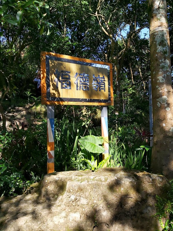
We saw a sign saying we were heading to Fudelin 福德嶺. We basically hiked on the ridge, so we either got to see
the mountains on one side or overlook the buildings in Taoyuan on the other.
Then, we arrived at Mt. Yuan 鳶山, 321 meters (1,053 feet), also called Mt. Fudekeng 福德坑山. There wasn't much
view here. Uncle Slow wanted me to take a photo of him and send him via Line, a popular messenger app in
Taiwan like WhatsApp. If you are curious, I never send the photo to him because I don't want to. Sorry for not
being sorry...
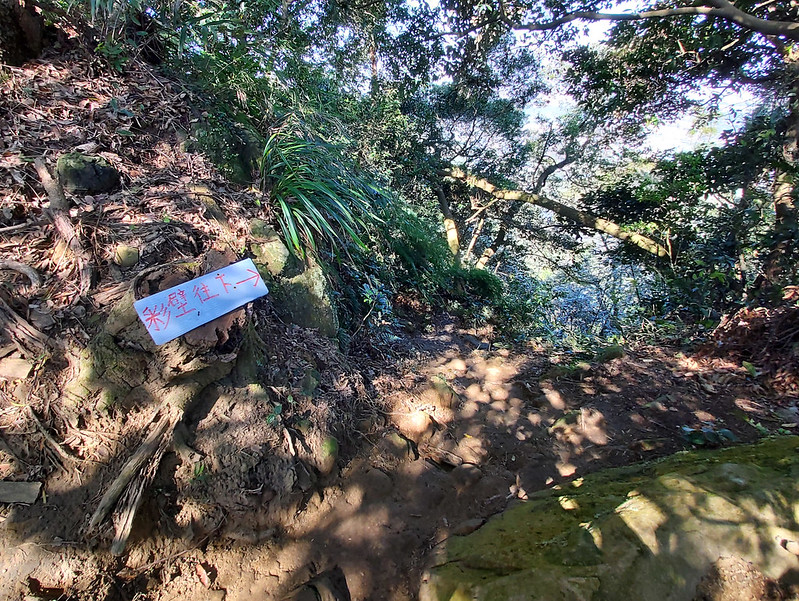
A Detour to Beautiful Cliff Wall and Mt. Wushifen
After Mt. Yuan, I saw a sign pointing to a direction to Yongan Temple 永安宮, but I never got there. With a big
burden/distraction like Uncle Slow, I missed many details and didn't take as many photos as I'd like to on the
trail.

Plotting to Get Rid of Uncle Slow
Here, we met a group of hikers coming from Miaoli 苗栗. I had a chat with them and learned that they planned to
see the Sanxia Colorful Cliff Wall 三峽彩壁 and turn back from Mt. Wushifen 五十分山. I wasn't planning to see the
cliff wall because there were so many people, but I changed my mind at the last minute. Uncle Slow didn't want
to go because he was already out of breath.
In fact, it took only a few minutes to get to the cliff wall. It wasn't big but the colors were stunning.
According to
a hiker's post, the colors were caused by Lichens. The vibrant colors were truly
impressive.

When I got back to where Uncle Slow was, he told me that he didn't want to go to Mt. Wutuku 烏塗窟山, and he
wanted me to pick him up after I got back from Mt. Wutuku. Since when I became his personal guide taking his
request???

So, I started plotting to get rid of him. Many hikers are friendly and willing to help other hikers in need. I
have to admit that I'm not that friendly, but I don't think Uncle Slow is a responsible hiker, either. He
didn't do homework and he WAS LATE. It wasn't my responsible to help him since he was not in danger, and my
patience was wearing thin.
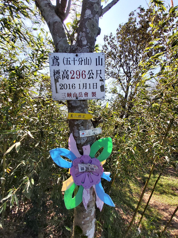
When we reached Mt. Wushifen 五十分山, 296 meters (972 feet), also called Mt. Yuan 鳶山 (two Mt. Yuan???), I told
him we took a break here. The view on Mt. Wushifen was great, even though it was crowded there. But I was
happy to see the crowd because I told Uncle Slow that the following trail was long, and it would take him much
longer to finish. So, I asked him to go with those hikers.

I could tell Uncle Slow wasn't very pleased, but that wasn't my concern. He had ruined my hike and I decided
enough was enough. After taking photos, I said goodbye to him, hoping never to see him again. Finally, my solo
hike had begun.
Enjoy My Solo Hike Again to Mt. Wutuku and Mt. Niangzhikeng
The following trail was steeper than the previous section, but still easy to hike. And most importantly, I
felt much better without Uncle Slow. I could make my own pace and really enjoyed being alone. I started paying
attention to my surroundings and mountains in the distance.

I took my time to have a long lunch. When I was having a lunch break, I met a huge group of hikers. Those
hikers were the group hike Uncle Slow intended to join, but not my concern now. I let them go first, but I
knew I would eventually meet them again.

After my one-hour lunch break, I headed to Mt. Wutuku, 烏塗窟山, H283 meters (928 feet). Like Mt. Yuan, there
wasn't much view to see there. So, I resumed my hike to the next peak.

It was late February, and the sun made the trail so pleasant to hike. Before reaching Mt. Niangzhikeng 娘子坑山, I
went through a road that cut the trail in half. I met those group hikers again, so I followed behind them. The
GPS Coordinates to enter the other half trail are 24.908180, 121.319764.

On the side of the road, I saw a cherry blossom tree. The hot pink color of the flowers was brought out more
intense by the chilly blue sky. No wonder many people enjoy viewing cherry blossoms so much.

After connecting to the trail to Mt. Niangzhikeng, the trail became more complicated because of several
junctions. It was good that I followed those group hikers so I didn't have to navigate which one I should go,
but I also kept my distance from them.

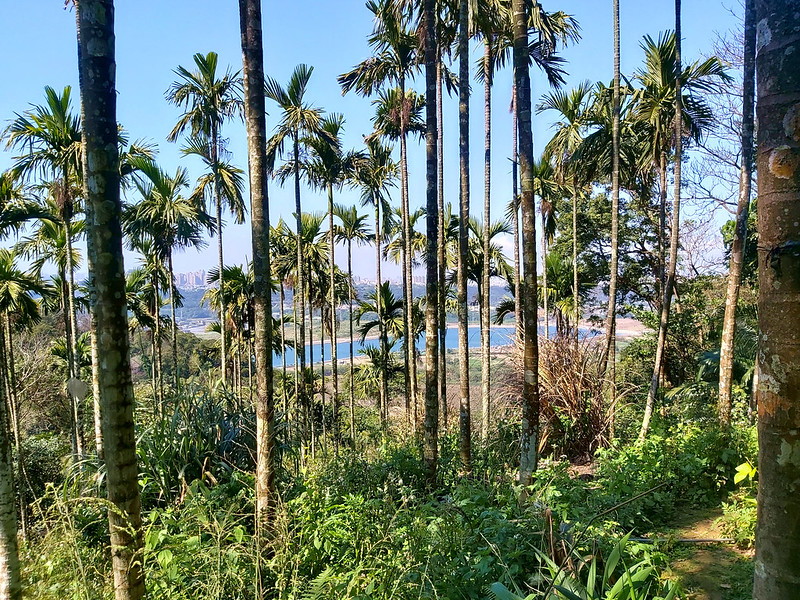
While hiking on the trail, I saw a lake through the lanky betel-nuts trees. That was Yuanshan Weir 鳶山堰 built
for water supply for 2 million people and irrigation, located between Sanxia 三峽 and Yingge 鶯歌.
I Almost Got Lost
When we reached Mt. Niangzhikeng, 238 meters (781 feet), I saw those hikers were queueing up to take photos
with the Control Point. I sat behind the trees waiting for them to finish.

Finally, I was alone again. I took my time to take photos and enjoyed the sun. It was quiet and warm, which
was my favorite moment on the trail. I was thinking about following them, but I brushed the idea aside because
I wanted to enjoy my solitude. I saw where they were going, so I followed the same direction later, which
turned out to be a big mistake.

According to my GPS map, there was only one trail, but for some unknown reason I thought I saw some junctions.
I made several wrong turns, but still couldn't find the right one. I started to panic, but I also knew that I
wasn't far from the exit of the trail.

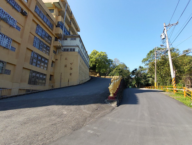
I think it took me more than 10 minutes to find the right trail. I still have no idea what was going on, but I
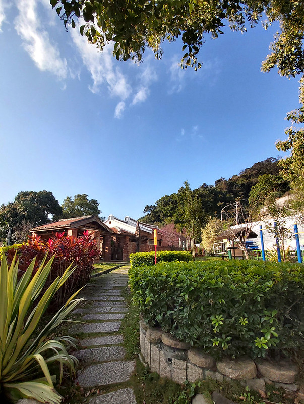
was happy that I found my way out. The trail connected to a road and a residential area. Then I reached Miaofa
Temple 妙法寺 in Daxi, Taoyuan, and took the bus close to the temple. Please note that Bus 9103 comes everyone
hour. It took me almost 45 minutes to wait for the bus to come.
Thoughts about This Hike: When Nature and Old Streets Meet
This is an easy and pleasant trail to hike. Although there are several junctions on this trail, there are also
many signs, marks and maps with English texts to help you navigate. It's still recommended to have a GPS with
you just in case.

If there aren't many people at the Colorful Cliff Wall, you can spend some time to see the details on the
wall.
If you want to visit Daxi Old Street, take Taoyuan Bus 9103 on the Miaofa Temple side and you can get to enjoy
the street food and old buildings. But 9103 is the only bus near Miaofa Temple and it takes one hour to wait
for the next one to come.

If I do this trail again, I will start the hike from Miaofa Temple in Daxi instead. After you finish the hike,
you can get to Sanxia Old Street right away and there are many buses going to Banqiao and MRT stations.
Have you been to Sanxia Old Street? Are you also looking for mountains to hike in Sanxia? If so, you can
consider this one. Please leave comments below and subscribe to newsletters for more amazing trails in Taiwan.
Map and Itinerary
Group Hike or Solo Hike: Solo hike
Date of Hike: February 23, 2020
Date of Hike: February 23, 2020
Click Menu in the map to download, print or share the map.
Click to change the speed to meet
your condition.
to change the speed to meet
your condition.
Note:
My GPS track may not be totally accurate and is for reference only.
Click
to change the speed to meet
your condition.Note:
My GPS track may not be totally accurate and is for reference only.
Based on my hike on February 23, 2020
07:47
Arrived at Sanxia Public Market and went to the toilet
07:57
Reached Nanran Park (Indigo Dyeing Park) and got my gear
ready
08:08
Got to the trailhead
08:13
Walked on Yuanfeng Road
08:24
Passed Tzuhui Temple and took photos at the pavilion
08:33
Reached another pavilion to oversee Sanxia Interchange
08:39
Passed the junction with the sign of Mt. Yuan
08:45
Reached Yuanshan Memorial Bell at Yuanshan Park
08:49
Reached the trailhead of Mt. Yuan and the map with a mark #1. Met
Uncle Slow while finishing my breakfast.
09:12
Hiked on the real dirt trail
09:23
Reached a small deck to admire the view
09:39
Saw the timber post pointing the direction to Mt. Fudekeng
09:43
Saw the mark #4
09:49
Reached Fudelin and took photos
10:08
Saw the mark #6
10:26
Arrived at the junction to Sanxia Colorful Cliff Wall
10:31
Reached Sanxia Colorful Cliff Wall
11:02
Reached Mt. Wushifen
11:45
Had a long break to have lunch and rested for one hour
13:06
Reached Mt. Wutuku
13:15
Crossed over the road to connect to the trail to Mt. Niangzhikeng
and saww the beautiful cherry tree blossoms
13:21
Saw a trail junction and took the left one
14:02
Reached Mt. Niangzhikeng and waited for the group finishing
taking photos
14:19
Resumed the hike but got lost
14:47
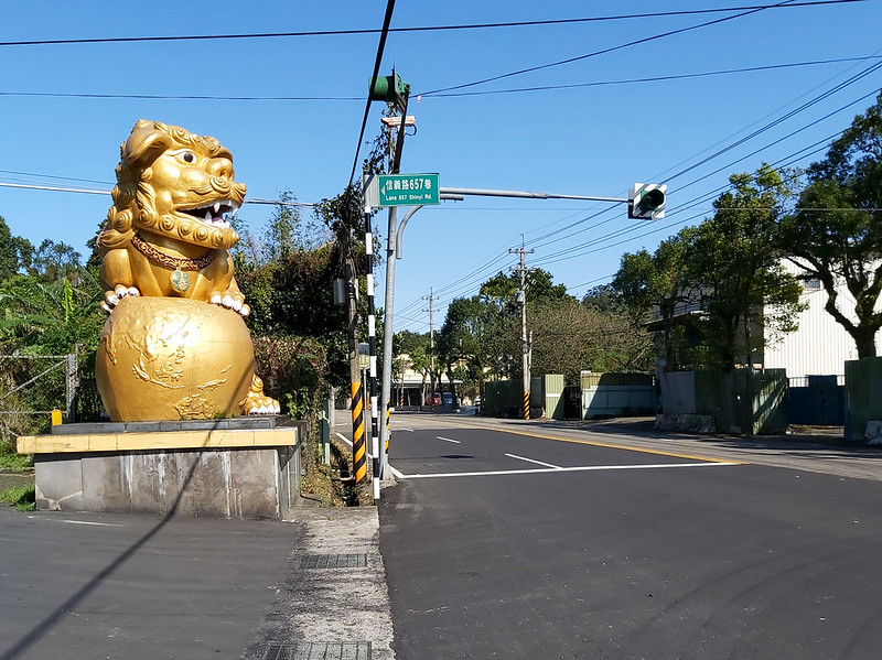
Reached Daxi Miaofa Temple on Lane 657, Road Xinyi
14:50
Reached the bus stop across the road but waited for 40 minutes
for the next Bus 9103 to come
Total time:
7 hours 3 minutes, including long breaks