Discover the Majestic Peaks of Mt. Keelung: A Comprehensive Hiking Adventure in Jiufen
Experience the enchantment of Mt. Keelung, an exquisite gem nestled near the vibrant Juifen Old Street. The
height seems modest, but this trail offers a breathtaking tapestry of coastal and mountain vistas that will
leave you captivated. If you're feeling adventurous, hiking from Mt. Keelung East Peak is a great alternative
when exploring the captivating wonders of Juifen and Ruifang in Taiwan.


Disclaimer:
All content is for inspiration only. Use Taiwan Hikes' suggestions at your own risk. We are not responsible for any losses, injuries, or damages.
All content is for inspiration only. Use Taiwan Hikes' suggestions at your own risk. We are not responsible for any losses, injuries, or damages.
Table of Contents:
About Mt. Keelung: Listed No.1 on 10 Gold Ridgelines
Mt. Keelung 基隆山 is also known as Mt. Chicken Coop 雞籠山 because its shape looks like a chicken coop. But the
pronunciation of chicken coop in Chinese is exactly the same as Keelung. Mt. Keelung also has a third name,
called Beauty with Big Belly Mountain 大肚美人山, also because of its shape that looks like a big-bellied beauty
lying down there.
From a geologic perspective, Mt. Keelung Main Peak and East Peak belong to the Chilung Volcano Group (aka Jilong or Keelung Volcano Group), formed about one million years ago.
It's inactive now, so there's no need to worry about the eruption. What made the Chilung (Keelung) Volcano
Group different from other groups in Taiwan was the majority of the Chilung (Keelung) Volcano Group consisted
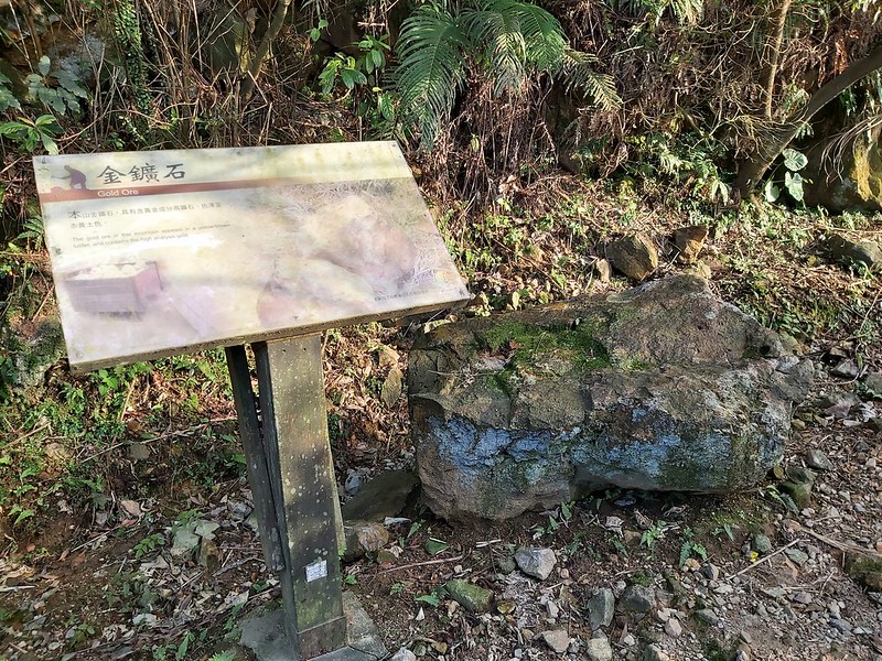
of Dacite. In short, Dacite was why Jiufen and Jinguashih were full of gold and copper ores in the old days.
I'm not a geologist. Please let me know if I need to correct anything here.
From the historical perspective, Jiufen and Jinguashih experienced mining booms because of the gold and copper
ores. As a result, they established their unique culture, which makes the whole so memorable and nostalgic and
has become a top-rated tourist attraction locally and internationally.
From a hiker's perspective, many fantastic trails have spectacular mountains and ocean views. Ruifang District
(where Jiufen and Jinguashih are located) is heaven for hikers.

As to Mt. Keelung Main Peak and East Peak, this trail is listed No. 1 on Gold Ridgelines Hikes, and the trail
is right next to Jiufen, which makes this hike more appealing. Like Mt. Teapot,
another famous hike in Ruifang, you can take the challenging or just the easy part.
10 Gold Ridgelines in Ruifang
10 Gold Ridgelines, a list of beautiful hiking trails in Ruifang, New Taipei
City, was established by a famous hiker and author, Mr. Lin Tsung-sheng 林宗聖.
1 黃金一稜 Gold
Ridgeline No. 1
Mt. Keelung Ridgeline: from Mt. Keelung to Mt. Keelung East Peak
Mt. Keelung Ridgeline: from Mt. Keelung to Mt. Keelung East Peak
2 黃金二稜 Gold
Ridgeline No. 2
Chimney Ridgeline: from Mt. Teapot, via abandoned mine chimneys to Mt. Shuinan ridge
Chimney Ridgeline: from Mt. Teapot, via abandoned mine chimneys to Mt. Shuinan ridge
3 黃金三稜 Gold
Ridgeline No. 3
Mt. Teapot Ridgeline: from Mt. Teapot to Mt. Banping and turn to Mt. Cao
Mt. Teapot Ridgeline: from Mt. Teapot to Mt. Banping and turn to Mt. Cao
4 黃金四稜 Gold
Ridgeline No. 4
Fukan (Overlook) Ridgeline: from Juchi (Zigzag) Ridge 555 Peak on Mt. Banping to Huangjin (Gold) Pond
Fukan (Overlook) Ridgeline: from Juchi (Zigzag) Ridge 555 Peak on Mt. Banping to Huangjin (Gold) Pond
5 黃金五稜 Gold
Ridgeline No. 5
Jianlong Ridgeline aka Stegosaurus Ridgeline: from Juchi (Zigzag) Ridge 381 Peak to Mt. Banping Suiba.
Warning: this trail can be dangerous. Stay out of the trail when it rains or you fear heights.
Jianlong Ridgeline aka Stegosaurus Ridgeline: from Juchi (Zigzag) Ridge 381 Peak to Mt. Banping Suiba.
Warning: this trail can be dangerous. Stay out of the trail when it rains or you fear heights.
6 黃金六稜 Gold
Ridgeline No. 6
Juchi (Zigzag) Ridgeline from Mt. Banping 713 Peak to Mt. Suiba.
Warning: this trail can be dangerous. Stay out of the trail when it rains or you fear heights.
Juchi (Zigzag) Ridgeline from Mt. Banping 713 Peak to Mt. Suiba.
Warning: this trail can be dangerous. Stay out of the trail when it rains or you fear heights.
7 黃金七稜 Gold
Ridgeline No. 7
Mt. Nanzilin Ridgeline: from Mt. Cao left junction to Mt. Nanzilin
Mt. Nanzilin Ridgeline: from Mt. Cao left junction to Mt. Nanzilin
8 黃金八稜 Gold
Ridgeline No. 8
Mt. Shitikeng Ridgeline: from the right junction of Mt. Cao to Mt. Shitikeng
Mt. Shitikeng Ridgeline: from the right junction of Mt. Cao to Mt. Shitikeng
9 黃金九稜 Gold
Ridgeline No. 9
Mt. Bitou Ridgeline: from Mt. Nanya to Mt. Bitou
Mt. Bitou Ridgeline: from Mt. Nanya to Mt. Bitou
10 黃金十稜 Gold
Ridgeline No. 10
Longdong Ridgeline: from Mt. Hemei to Longdong Bay
Longdong Ridgeline: from Mt. Hemei to Longdong Bay
How to Get There
There are several buses to the trailhead. My favorite and recommended one is to take Keelung Bus 基隆客運 1062 from Exit 2 MRT Zhongxiao Fuxing Station 忠孝復興捷運站 and get
off at Jiufen Old Street Stop 九份老街站. After getting off, continue to walk for about 300 meters, and you will
find the trailhead of endless steps to Mt. Keelung Mian Peak. You can find toilets on both sides of the road.
Other options:
Take Keelung Bus 788 from Keelung Train Station or Ruifang Train Station and get off at Geding Stop 隔頂.
Take Bus 965 from Banqiao Train Station or Ruifang Train Station and get off at Geding Stop.
Take Keelung Bus 788 from Keelung Train Station or Ruifang Train Station and get off at Geding Stop 隔頂.
Take Bus 965 from Banqiao Train Station or Ruifang Train Station and get off at Geding Stop.

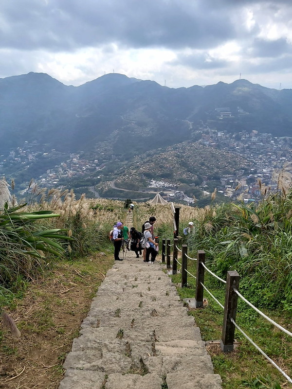
The Easiest One: Take Mt. Keelung Main Peak Only
GPS coordinates of Mt. Keelung trailhead: 25.111772, 121.847430
After getting off at Geding Stop, you walk back toward Jiufen a few meters and see the trailhead with a sign.
If you take this one, you follow the endless stone steps and go up. There are three pavilions (the last is
your destination) to take a short break and enjoy the mountain views.

Some might argue that taking endless stone steps is challenging, and I agree. But if you don't hike regularly
or are unfamiliar with the jungle-like terrains in Taiwan, I still recommend starting from here, and you won't
get lost as long as you keep going up. All the efforts will pay off when you get to the top.

When you finally reach the top, which takes around 30 minutes, you'll see the last pavilion and a small square
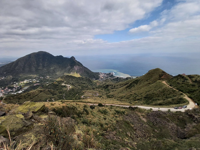
in front of it. This spot is your hiking destination, the peak of Mt. Keelung with a height of 588 meters
(1,929 feet) above sea level, and there's a Class 3 Triangulation Stone.

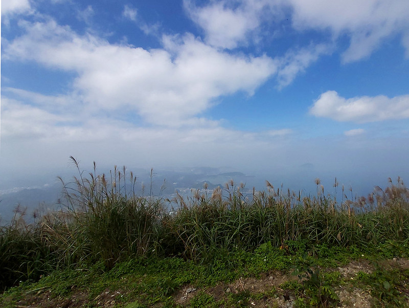
You can take your time, watch the surroundings, and be amazed by the mountains and the ocean if the weather is
gorgeous. You can also see Keelung Islet 基隆嶼 on the right in the following photo.
After you are ready, you can take the same stone steps back to the main road and walk to Jiufen or the nearby Gold Museum and other tourist attractions.

From Main Peak to East Peak but Not Recommended
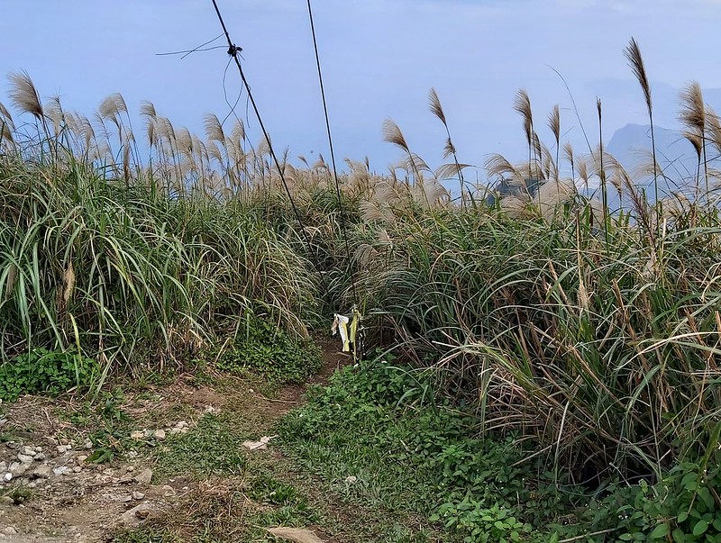
If you continue the hike, you must find another trail entrance next to the main peak's electric power lines.
When you take this trail, the grass on both sides can be very tall, but the trail is relatively easy to find.
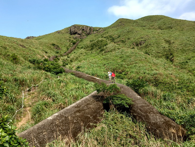
You can feel descending, and you will see a huge rock slope.
I took this one when it was drizzling. When I saw the steep slope, I thought my heart skipped one beat, but my
friend and I kept going. Hiking on this trail during the rain is not fun. Therefore, if the weather is wet,
please turn back.
Even though it's not raining, it might make you cringe by looking down the slope. I didn't take a photo from
the top down during both my trips because I got panic and just wanted to move on as soon as possible. Of
course, there are ropes to grab, but looking down the slope will make you uneasy if you aren't comfortable
with the height.

Take it slow and make sure your hands hold on tight with the rope, and you should be fine. During my first
attempt to get down the slope, I slipped, and my friend later told me that she saw me hitting the rock.
Luckily, my hands were still holding the rope tightly, and I had a small bag in front of my chest, which
absorbed some impact for me.

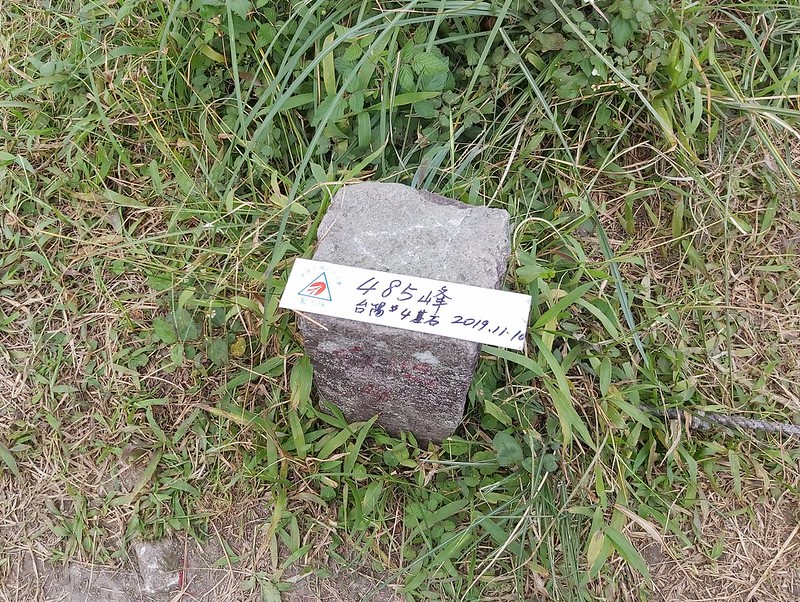
When you get down the steep slope, the trail becomes relatively flat and easier to hike, and you will see a
hill with a tree near the peak, 485 Peak 485 峰. As you can guess, it's 485 meters (1,591 feet) above sea
level. Standing here, you get to see how far you've gone, and you can also see Mt. Keelung East Peak.
485 Peak is close to Mt. Keelung East Peak. You will see a trail junction, and please take the one straight if
you want to go to the east peak. The one going downhill will take you back to the other side of the trailhead.
Unless the weather isn't good, I suggest you go to Mt. Keelung East Peak. The views there are even more
impressive than those on the main peak.

After you finish the east peak, the sightseeing is over, and what's waiting for you is the challenging jungle
hike. I'll explain more in the following.
The Hard Core One: from East Peak to Main Peak
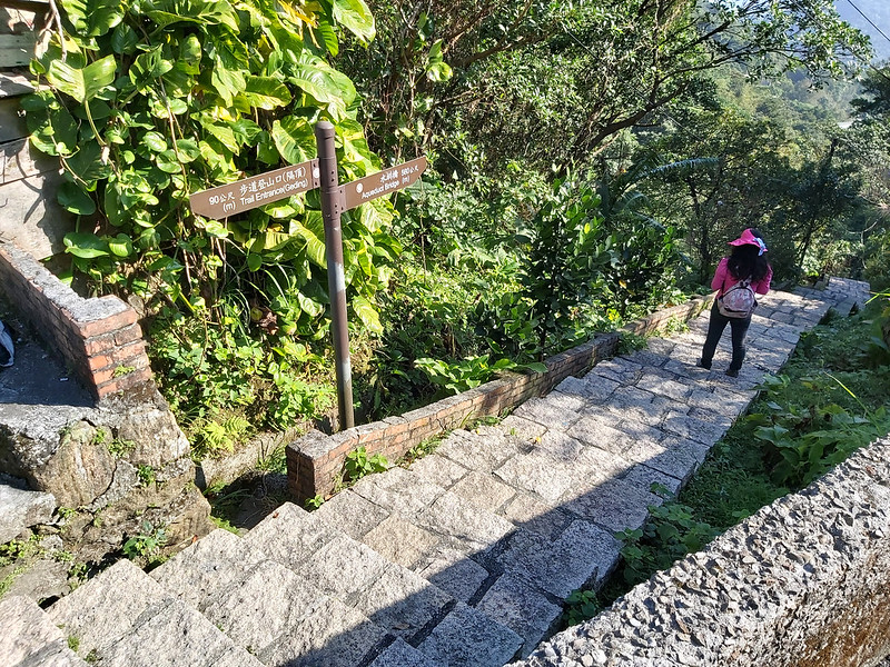
After I took this hike from both ends, I highly recommend you to take this one. After you get off Geding Stop,
you will see a pavilion-like bus stop building and a stone step trail going down. Take this one, and you will
see the sign before another stone steps.

After this, you get to walk on the regular road again. Unfortunately, this trailhead isn't that obvious
compared to the other one, and you'll see a road junction, and you have to take a left to get to the
trailhead.
Once you see the trailhead with many plastic ribbons, the jungle trail is waiting for you. Although it's like a jungle,
the trail is easy to find. There are many plastic ribbons on the trees left by other hiking groups. Follow
those ribbons if you can't find the trail.
GPS coordinates of Mt. Keelung East Peak trailhead: 25.115219,121.852747

However, there are many rocks, and the terrain is intertwined with tree roots and steep and slippery. There's
nothing much to see in the woods. All you can do is keep going and look forward to seeing the view when you
reach the peaks. If it's raining, it will be more challenging to hike on this trail, not to mention the slope
climbing part later.

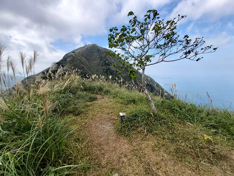
Once you climb to the ridge, you will see a trail junction. Take the right one, and you'll arrive at Mt.
Keelung East Peak. The views on the east peak were more striking than those on the Main Peak and 485 Peak.

While on the East Peak, you can see 485 Peak and Mt. Keelung Main Peak ahead of you, and the steep grade of
those peaks is impressive. Take your time to climb those slopes. However, if you think your fear of heights
kicks in, please don't hesitate to tell your guide or hiking mates and ask for help. Local hikers are very
friendly when you need their help.

Climbing up those rock slopes might be easier than going down, but it was still scary. I felt my arms and legs
were sore when trying to grab the rope and find my footing.

The Main Peak was still ahead, so we continued our hike. After going through tall grass, we reached the Main
Peak. Many tourists were already here to enjoy the excellent weather, and we could finally take a long lunch
break.

It takes less than 3 hours to finish those peaks from the difficult end to the easy one. After you leave the
trail, the bus stop is near. I was able to catch the bus right after I finished my hike.
Other Routes
This hike is excellent for people with tight schedules. You can go hiking to Mt. Keelung Main Peak, and
visiting Jiufen and Jinguashih later is doable and lets you make the most of it in one day.

For those who want to take a challenging hike and see the fantastic views only in northeastern Taiwan,
starting your hike from the Mt. Keelung East Peak side to the Main Peak is highly recommended. However, if you
take this route, please be cautious when climbing the rocks.
There are other routes to take on this hike. For example, some hikers start from the trailhead near Lian Dong Elementary School 濂洞國小 and hike to Mt. Keelung East Peak and then
the main one. This route is short but more intense than just doing the East and Main Peak. I haven't tried
this one yet, but I might try it.
Map and Itinerary
Group Hike or Solo Hike: Group hike with 新北市山岳協會 THMA
Date of Hike: November 17, 2019
Date of Hike: November 17, 2019
Click the Menu in the map to download, print, or share the map.
Click to change the speed to meet
your condition.
to change the speed to meet
your condition.
Note:
Due to GPS accuracy setting, there may be some difference between my GPS tracking and the exact distance. Please check the infographic above for more accurate data.
Click
to change the speed to meet
your condition.Note:
Due to GPS accuracy setting, there may be some difference between my GPS tracking and the exact distance. Please check the infographic above for more accurate data.
Based on my hike on November 17, 2019
09:00 Started the
hike. The guide took some time to explain the trail.
09:23 Reached the
trailhead to Mt. Keelung East Peak
10:11 Reached the
first big slope
10:20 Reached Mt.
Keelung East Peak
10:58 Arrived at the
second big slope
11:06 Reached 485
Peak and took photos
11:30 Reached Mt.
Keelung Main Peak and had lunch
11:47 Got down from
the stone steps
12:00 Reached the
trailhead and bus stop
Total time: 3 hours,
including breaks