The Hidden Bitoujiao Trails You Didn't Know About and Lighthouse Adventure in Taiwan
Discover the breathtaking allure of the Bitoujiao (Bitou Cape) Trails, offering a mesmerizing glimpse into the
coastal beauty of northeastern Taiwan. While many are familiar with the favored Bitoujiao Valley Trail, this
post reveals the lesser-known gem—the trail leading to Bitoujiao Lighthouse. Prepare to be captivated as we
guide you through all the remarkable trails, showcasing the awe-inspiring views that await you at Bitou Cape.
Disclaimer:
All content is for inspiration only. Use Taiwan Hikes' suggestions at your own risk. We are not responsible for any losses, injuries, or damages.
All content is for inspiration only. Use Taiwan Hikes' suggestions at your own risk. We are not responsible for any losses, injuries, or damages.
Table of Contents:
How to Get There
From Ruifang Train Station to Bitoujiao: Bus 886 and Gold Fulong Shuttle Bus 856
Please note you need to turn left after getting off at Ruifang Train Station to the bus stop. Heres what the bus stop looks like.

Take bus 886, the one to Hemei Elementary School direction, and get off at 17 Bitoujiao shown on
886's live arrival time.
Or take Gold Fulong Shuttle Bus 856, the one to Magang direction, and get off at Stop 10 Bitou shown on 856's live arrival time.
Option 2: Take Keelung Bus 791 at Keelung Train Station
Take bus 791, the one to Fulong direction, and get off at 53 Bitoujiao shown on 791's live arrival time.
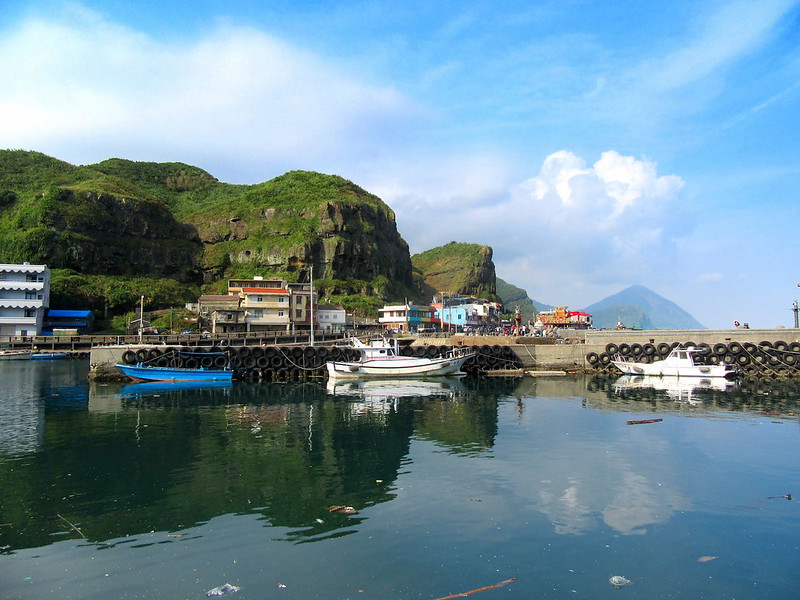
After you get off the stop, you will see Bitou Fishing Harbor 鼻頭海港 on your left, and the sign to Bitou
Elementary School 鼻頭國小 in front of you. You can take the overpass next to the bus stop to get across the road
to reach Bitou Road 鼻頭路.

GPX/Maps
If you follow the steps on Bioutjiao Valley Trail, it's fine to hike without a map. I share my latest hike in
March 2023 when I hiked to Mt. Bitou.
Route map for Bitoujiao Valley Trail by Anusha Lee on plotaroute.com
Click Menu in the map to download, print, or share the map.
You can see more options after clicking the Play button.
Click to change the speed to meet your condition.
You can see more options after clicking the Play button.
Click
to change the speed to meet your condition.
Bitoujiao Valley Trail and Wave Crashing Camp
Distance: 5.4 km (3.3 miles)
Route type: loop
Days/Hours Needed: 2-4 hours
Total Ascent/Descent: 269m/323m
Best Time to Go: All year round
Permits: Not required
Difficulty Level:
Days/Hours Needed: 2-4 hours
Total Ascent/Descent: 269m/323m
Best Time to Go: All year round
Permits: Not required
Difficulty Level:
The Bitoujiao Valley Trail, located in Northeast Taiwan, is renowned as the easiest and most popular route for
experiencing the breathtaking coastline. To embark on this trail, simply follow the endless steps adjacent to
Bitou Elementary School, and be prepared to be amazed.

This small elementary school stands out among others in Taiwan due to its unique location. One notable feature
near the school's entrance is a striking picture that captures attention.

Our guide informed us that the trail next to the school is an ideal spot for witnessing stunning sunrises and
sunsets. It's rare to find a place like this.

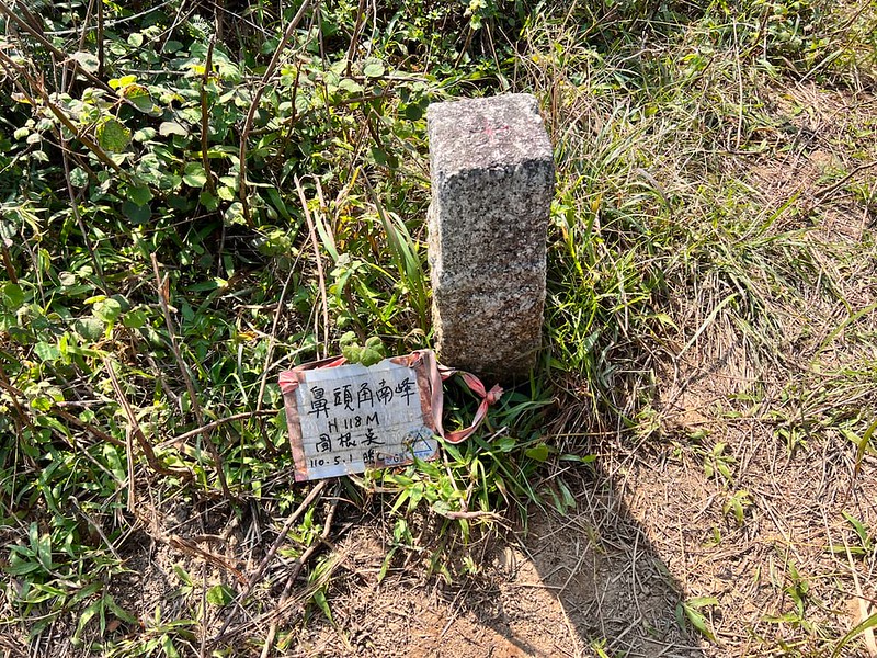
A Detour to Mt. Bitou, but Not Recommend
I noticed a footpath on the left. Driven by my curiosity, I decided to explore this path, which my map indicated
led to Mt. Bitou. It's obvious that only a few people took this route, but this route was manageable, offering
beautiful views along the ridge.
Eventually, I reached the summit, known as Mt. Bitou, 118 meters above sea level, despite the sign indicating it
as Mt. Bitoujiao South Peak. As the trail descended, I arrived at a pavilion that can be spotted if you stick to
the step trail. Based on my experience, I recommend following the steps rather than this alternative route.

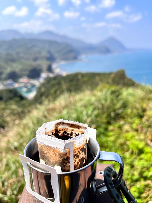
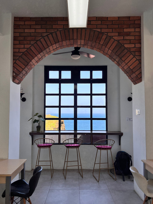
A Beautiful Cafe: Wave Crashing Camp
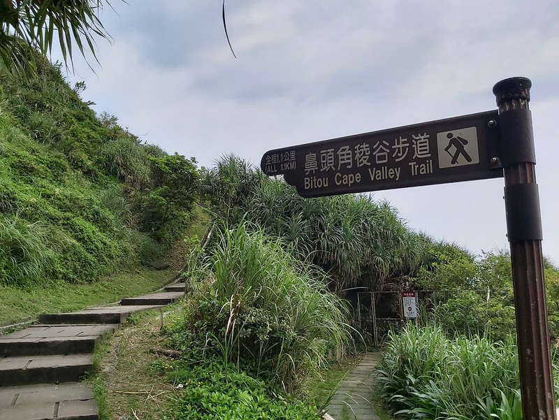
Continuing along the steps, you will encounter a junction with a sign indicating the Bitou Cape Valley Trail.
Ascending the steps to the top, you will reach a corner with a closed gate marking a military base (no enter, of
course), along with two additional sets of steps.
As you descend, a colorful building called Wave Crashing Camp will come into view. This building was once an
abandoned military camp and has been transformed into a charming small cafe named Wave Crashing Cafe 聽濤咖啡 (Tingtao Cafe) since May 2020.
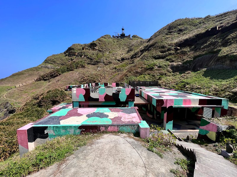
If you reach this point, take a well-deserved break, savoring the delightful views. Toilets are available here
as well.
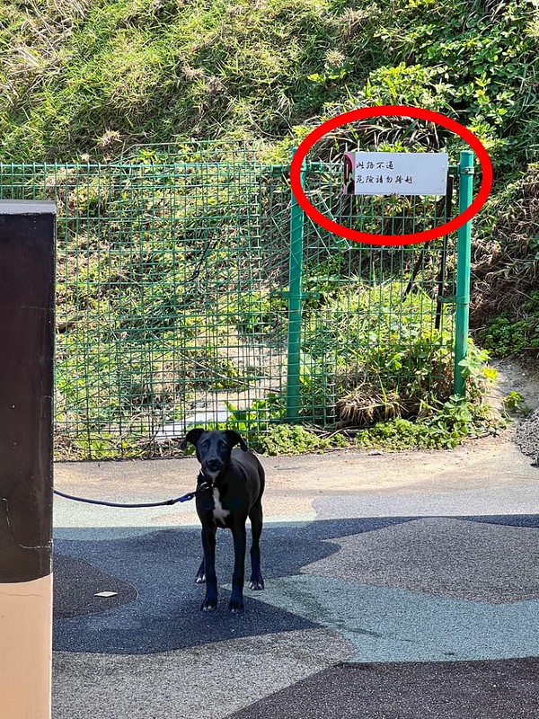
After enjoying a coffee break, I attempted to take the trail behind the Wave Crashing Cafe. However, a super
friendly dog greeted me by snarling and alerting me to a sign indicating I should not proceed. Fortunately, the
dog was restrained, and I obeyed his (her) demand.
A Small Detour to See the Cliffs
Although the vigilant dog prevented me from exploring the aforementioned trail, I discovered a footpath in front
of the Wave Crashing Cafe. This section proved to be steep, yet my map suggested it was a viable route.

Intrigued, I decided to take on this path. The views from this vantage point were truly remarkable, and I
spotted the rock resembling a penguin I saw in 2019. However, as the path ahead appeared challenging, I opted
not to push myself into an awkward situation and retraced my steps. Nonetheless, the views had made me happy
enough to leave with content.

Back to Bitoujiao Valley Trail
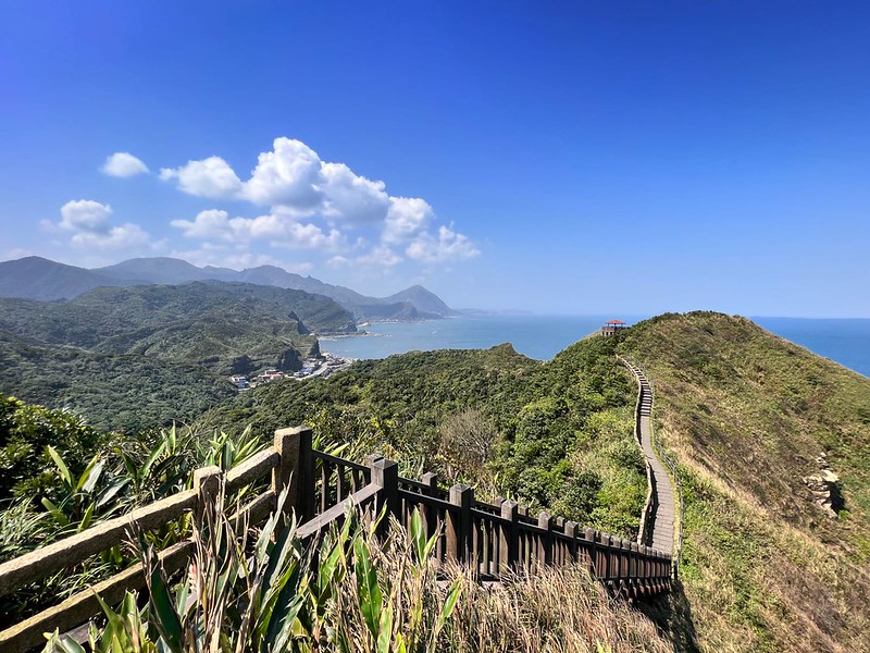
Returning to the Bitoujiao Valley Trail, it becomes evident that no map or GPX is required if you stick to the
steps. This trail offers mesmerizing panoramas of the entire Ruifang mountains.

While traversing this trail, take your time to appreciate the awe-inspiring landscapes that are unique to
Taiwan, savoring the experience to its fullest.


After admiring the views at the last pavilion, you can take the wooden stairs to Bitou Harbor and your next
destination.
You can also start your hike from this side. There's a temple, Xinxing Temple 新興宮, and signs for you to follow
the trail. I will suggest you start your hike from Bitou Elementary School, because you can have some local food
after your hike. Nothing much to eat near the school.

Bitou Cape Lighthouse Trail: Closed Due to Rock Erosion
Important Note: The following account is from my hike in October 2019, prior to the permanent closure of
the Lighthouse Trail in 2020. Although some hikers still attempt this route, please be aware that there is a
military base in the area. Trespassing may result in significant fines. Please verify the current status of
the trail before attempting it.

A Route Not for People Who Fear Heights
This trail is not recommended for individuals with a fear of heights. I personally encountered two particularly
challenging sections that required advanced climbing skills. To be honest, those moments were far from my
proudest. However, if you're comfortable with heights, this route offers a truly awe-inspiring experience.
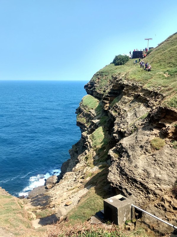
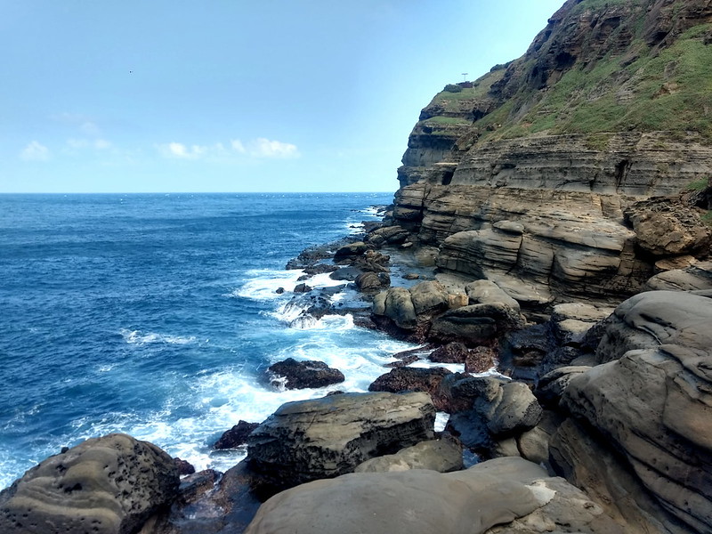
Our ascent took us to the towering hill behind Bitoujiao Lighthouse. The lighthouse gleamed brilliantly against
the lush cliff backdrop, with the deep blue ocean resembling a velvety canvas. From this vantage point, we
enjoyed breathtaking views of both sides of Bitoujiao. The geological park unfolded to my right, while Mt.
Keelung and Jiufen stood proudly to the left.
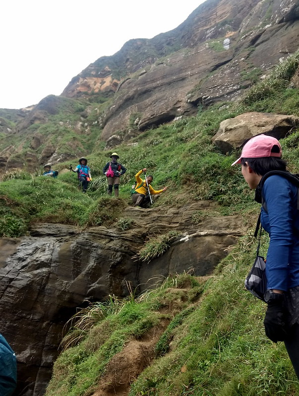
As we followed a narrow footpath along the hillside, the layered green hills and the contrasting blue hues of
the ocean and sky created a striking panorama. We observed fellow hikers progressing like tiny specks along the
narrow path, which allowed only one person to pass at a time.

During my hike in 2019, the trail was so popular that we encountered traffic jams at certain points. The descent
from the hill led us to a shaded spot where we took a lunch break.
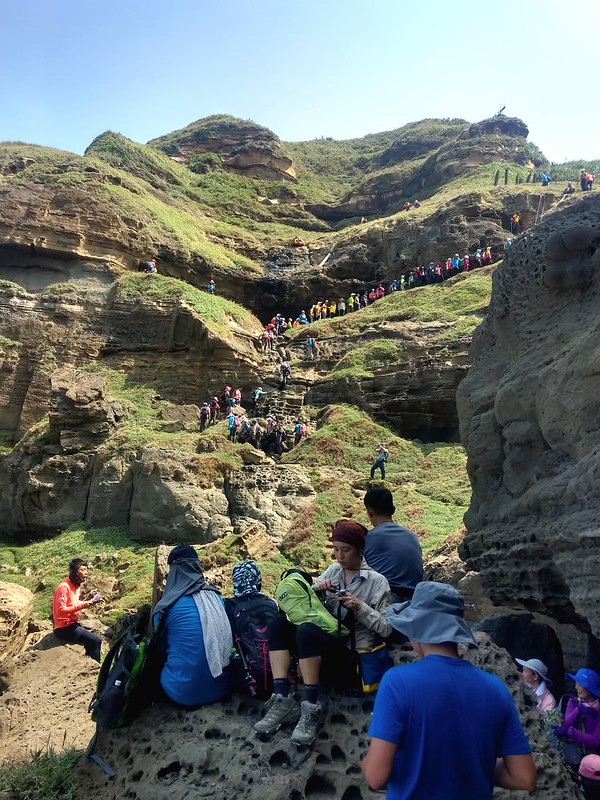
It was conveniently situated in front of the distinctive penguin rock formation.
While sitting there, I marveled at the impact of the waves on the rocks over millions of years, though I must
mention that this sight might not be suitable for individuals with trypophobia.

The Worst/Scriest Section of Bitoujiao Lighthouse Route
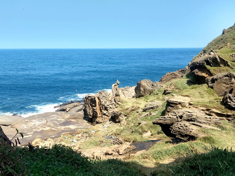
Following our meal, we continued along the rocky shoreline, which initially posed no significant challenges. The
area was adorned with countless magnificent rock formations, and we couldn't resist capturing numerous
photographs. However, as we progressed, we reached a slope.
For experienced rock climbers, this slope may be inconsequential, but for someone like me, it proved to be quite
terrifying. My fear overwhelmed me, and I found myself unable to proceed. Fortunately, my considerate guides and
fellow hikers provided support and reassurance, helping me regain composure and complete the descent.
Once we safely reached a secure spot, we continued walking along the rocky shore. I will recount this part in
the subsequent section.

Discover the Hidden Gem Next to Bitou Beach Park: Cliff Caves
An unofficial trailhead awaits you next to Bitou Beach Park. While the footpath may not be immediately apparent,
the thrill of uncovering the cliff caves makes it all the more exciting.

Warning: Some tourists were swept here and drowned due to rogue waves. Before embarking on this
captivating journey, be sure to check the tidal waves for your safety. The local government even contemplated
closing this trailhead, emphasizing the need for personal responsibility.

Nevertheless, the majestic sea cliff caves still command attention amidst the marine debris that litters the
shore. These awe-inspiring cliffs have endured millions of years of sea erosion, evolving into true natural
wonders.

As I ventured further, I encountered the formidable rocks I conquered during my 2019 lighthouse trail
expedition—a thrilling memory that will forever linger in my mind.

As I strolled along Bitou Beach Park, my eyes were fascinated by an extraordinary sight—a rock that bore an
uncanny resemblance to the creature from the renowned movie, Alien 3. It was as if the extraterrestrial being itself had materialized right
before me. Now, I can't help but wonder, what are your thoughts on this discovery?

About Bitou Cape and Bitou Lighthouse
Bitou Cape or Bitoujiao
Bitou 鼻頭, which translates to "the tip of your nose" in Chinese, paints an intriguing picture. When you view it
on Google Maps, the place appears strikingly pointed. Bitoujiao, located in northeastern Taiwan, boasts an array
of captivating coastal erosion landforms, including majestic cliffs, mesmerizing sea caves, and wave-cut
platforms.

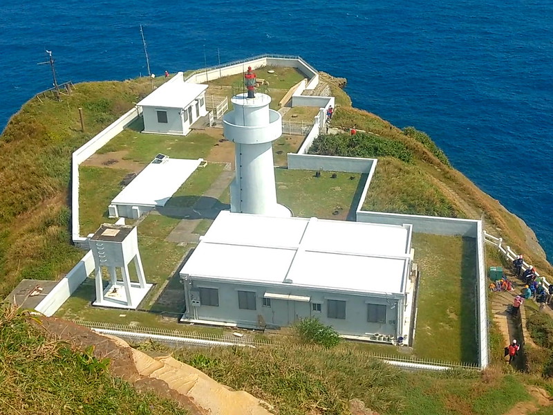
Bitou Cape Lighthouse 鼻頭角燈塔
The story of Bitoujiao Lighthouse adds to its charm. Constructed in 1897 during
the Japanese Occupation, the original lighthouse stood as an iron hexagonal structure until it succumbed to the
ravages of World War II. However, in 1971, it underwent a remarkable transformation, rising again as a
magnificent white tower made of concrete.
While the trail leading to Bitoujiao Lighthouse remains closed indefinitely due to the fragility of the
surrounding landscape and the potential danger of falling rocks caused by weathering, the lighthouse itself is
unfortunately inaccessible to the public.
Nevertheless, for those enchanted by Taiwan's lighthouses and eager to explore the ones open to visitors, a
visit to the Maritime and Port Bureau's lighthouse website is highly
recommended.