Complete Guide of Wufeng Skyline Hikes: Mt. Egongji and Mt. Niaozui in Hsinchu
Mt. Egongji is one of the most popular mountains to hike in Hsinchu Taiwan. Located in Wufeng, it is also one
of the Xiaobaiyue (Xiao Bai Yue), Minor 100 Peaks. Reaching the top, you'll see another famous Xiaobaiyue, Mt.
Jiali, from the distance. This trail is slightly rough. But if preschoolers can do it, you can enjoy it, too.
You will also find the complete guide and all the routes to enjoy the amazing mountains and trails in Hsinchu.


Disclaimer:
All content is for inspiration only. Use Taiwan Hikes' suggestions at your own risk. We are not responsible for any losses, injuries, or damages.
All content is for inspiration only. Use Taiwan Hikes' suggestions at your own risk. We are not responsible for any losses, injuries, or damages.
Table of Contents:
- About Mt. Egongji, Mt. Egongji Northeast Peak and Mt. Niaozui
- About Wufeng Skyline Trail: The Power of Volunteer Hikers in Taiwan
- How to Get There
- Peaks and Places to Reach
- Started with Views of Holy Ridge before Mt. Niaozui
- Watching Mt. Jiali from Mt. Egongji
- Mt. Egongji Northeast Peak in Japanese Cedar Trees
- Thoughts about this Hike and Other Routes
- Map and Itinerary
- Recommended Blogs and Resources
- Related Posts on Taiwan Hikes
About Mt. Egongji, Mt. Egongji Northeast Peak and Mt. Niaozui
Mt. Egongji is a famous minor 100 Peaks, Xiaobaiyue 小百岳. I did this hike with Taiwan
Mountain LOHAS Association, and this is part of Wufeng Skyline Trails 五峰天際線. I was hoping to finish all
the ten peaks of Wufeng Skyline Trails, but my knees hurt badly, which forced me to abort the hike to Mt.
Shangping 上坪山, Mt. Wuzhi 五指山 and Mt. Daiai 大隘山.
Thank the administor of a Facebook Page A Complete Guide to Hsinchu Wufeng Skyline
Trails 新竹五峰天際線完全攻略 for giving me permission to embed their posts about those hikes. The trail here is
the one I didn't finish.
The trail we took is almost parallel to my ridge hike to Mt. Nandagui,
Mt. Xiangtianhu and Mt. Guangtiangao in Nanzhuang. There are many hiking trails in this area, and you
can also check out Thoughts about this Hike and Other Routes
first to see how you can do those hikes.

Mt. Egongji: A Hike Even A 3-Year-old Can Do It
Mt. Egongji is in the border of Wufeng Township of Hsinchu County and Nanzhuang Township of Miaoli County.
Most residents are indigenous Saisiyat people 賽夏族. Saisiyat people
deem Mt. Egongji as a sacred mountain and call it “Ngangihaw”, meaning a high mountain. From the distance, it
is said that the outline of Mt. Egongji looks like the basal knob on a goose's bill. “E” means goose or geese,
“gong” means male, and “ji” means bun updos in Chinese. That's how it got this name, Egongji.
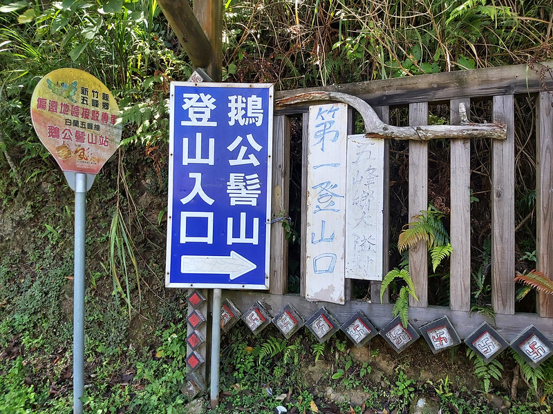
There are four trailheads to Mt. Egongji, but the most popular ones among them are No. 1 trailhead and No. 3
trailhead. Not. 3 trailhead is inside Shan Shang Ren Jia Farm Resort 山上人家休閒農場, and hikers
have to pay the tickets, NT$200, to hike this one. This resort is famous for the sea of clouds from October to
March.

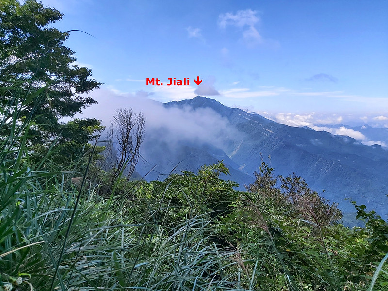
There is no view on Mt. Egongji, but there is a small footpath that can lead you to a slope and let you see the famous Mt. Jiali from the
distance.
The trail may look rugged, but I saw several preschoolers as young as 3 years old did the hike with their
parents when I was there.
The Bird Beak Mountain: Mt. Niaozui in Wufeng
Wufeng's Mt. Niaozui, literally meaning Bird Beak Mountain in Chinese, is in the border of Wufeng Township of
Hsinchu County and Nanzhuang Township of Miaoli County, and the south of Mt. Egongji. There are other two
Mid-elevation mountains, Mt. Bilin 比林山 1,811 meters (5,942 feet) and Mt. Dawo 大窩山 1,642 meters (5,387 feet),
and those trails can be connected to Mt. Egongji and Mt. Niaozui.
Some hikers nickname this long trail as Goose is Bigger than Bird 鵝比鳥大, because the first character of each
mountain in Chinese are Goose (E 鵝 in Mt. Egongji), Compare (Bi 比 in Mt. Bilin), Bigger (Da 大 in Mt. Dawo),
and Bird (Niao 鳥 in Mt. Niaozui), if you get what I mean.
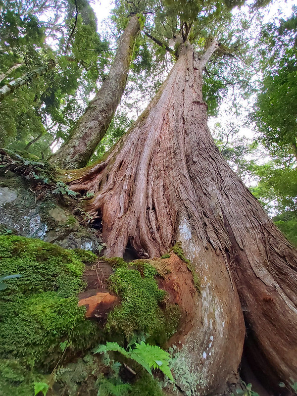
One thing worth mentioning is Youming Old Trees 尤命神木群 (aka Daying Old Trees 達硬神木群), which are located between
Mt. Bilin and Mt. Nanbilin. Those beautiful old trees were discovered by an indigious Atayal, Youming 尤命, from
Bailan Tribe 白蘭部落. Therefore, this area was named after him.

Three Mountains Called Bird Beaks (Niaozui) in Hsinchu
Three mountains contain Bird Beak in their names, and they are:
- Mt. Niaozui of Jianshi Township 尖石鳥嘴山, aka Mt. Neiniaozui 內鳥嘴山, 1,749 meters (5,738 feet), and is near the famous old trees near Beidelaman Trail 北得拉曼神木區.
- Mt. Niaozui of Guanxi Township 關西鳥嘴山, aka Mt. Wainiaozui 外鳥嘴山, 1,350 meters (4,429 feet), and is near Mawudu Discovery Forest 馬武督探索森林.
- Mt. Niaozui of Wufeng Township 五峰鳥嘴山, 1,550 meters (5,085 feet).

About Wufeng Skyline Trails 五峰天際線: The Power of Volunteer Hikers in Taiwan
Wufeng Skyline Trails have become very popular among Taiwanese hikers since 2019. In order to promote trail
running in Taiwan, an enthusiastic trail runner Webber Huang 黃偉柏 carried a lawnmower and cleaned up the
trails, and the idea of connecting those trails was born.
Later, Jiang Qixiang of Blue Sky Team 藍天隊江啟祥隊長 footed the
bill of hiring people to maintain the trails and work with Keelung Sunrise Hiking Association 基隆市朝陽休閒健行協會 to make aluminum signs and
plates. Then, several groups of volunteer hikers, like Mt. Chen whose blog helps me a lot,
put those signs and plates on each trail on countless Tuesdays and share the those to hikers.


You can check out more details on A Complete Guide to Hsinchu Wufeng Skyline
Trails 新竹五峰天際線完全攻略, and you can find the latest news, trail conditions or new routes, where to stay
overnight, arrange your pickups, and how to plan your routes to hike. You can use the translation tool on
Facebook if you don't read Chinese.
Without those people and volunteer hikers, we will not be able to enjoy the wonderful landscape and mountains
safely. Salute to those heroes!
The Full List of Mountains on Wufeng Skyline Trails
Here's the full list of mountains on Wufeng Skyline Trails:
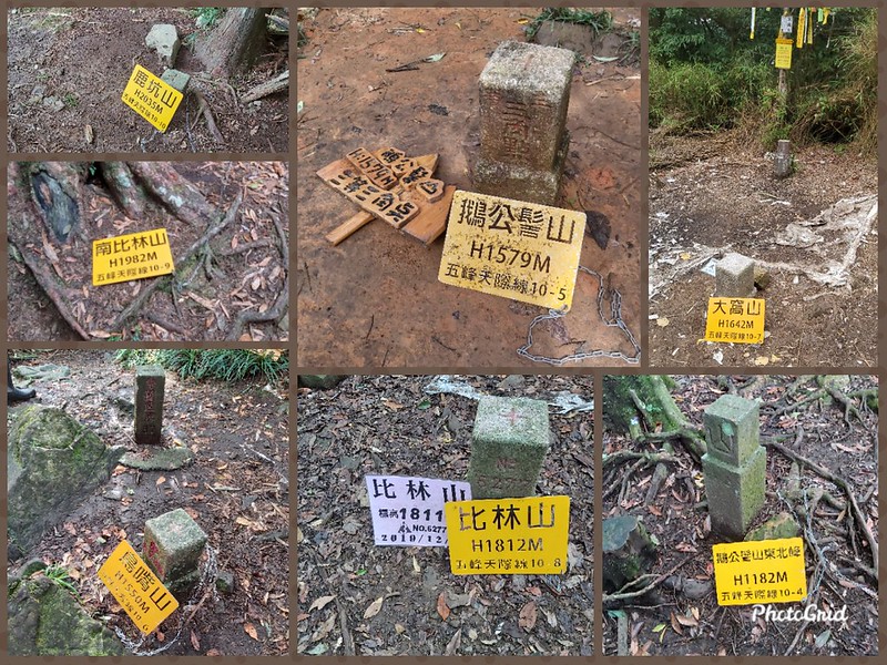
- 10-1: Mt. Shangping 上坪山, height 620 meters (2,034 feet)
- 10-2: Mt. Wuzhi 五指山, height 1,062 meters (3,484 feet). There is a Class 2 Triangulation Stone on the peak.
- 10-3: Mt. Daiai 大隘山, height 862 meters (2,828 feet).
- 10-4: Mt. Egongji Northeast Peak 鵝公髻山東北峰, height 1,182 meters (3,878 feet).
- 10-5: Mt. Egongji 鵝公髻山, height 1, 579 meters (5,180 feet). There is a Class 3 Triangulation Stone on the peak.
- 10-6: Mt. Niaozui 鳥嘴山, height 1,550 meters (5,085 feet). There is a Class 3 Triangulation Stone on the peak.
- 10:-7 Mt. Dawo 大窩山, height 1,642 meters (5,387 feet). There is a Class 3 Triangulation Stone on the peak.
- 10-8: Mt. Bilin 比林山, height 1,812 meters (5,945 feet). No views.
- 10-9: Mt. Nanbilin 南比林山 (South Bilin), height 1,982 meters (6.503 feet).
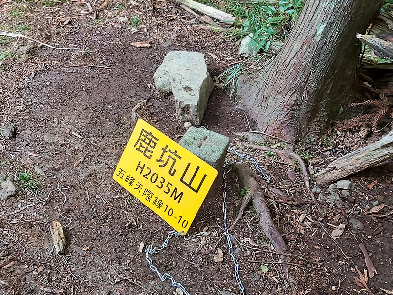
- 10-10: Mt. Lukeng 鹿坑山, height 2,035 meters (6,677 feet).

A Hike That Needs to Be Done
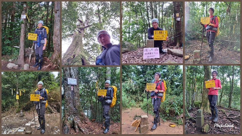
I only finished 7 out of the 10 mountains on Wufeng Skyline Trails. Hopefully, I'll get a chance to finish the
rest in the future. Here is the collage of peak photos and Youming Old Trees.
I saw several beautiful endemic wildflowers on those trails, including alvia nipponica var. formosana 黃花鼠尾草,
Taiwan Bicornuta 角桐草 and Strobilanthes formosanus Moore 台灣馬蘭. You can check out my Wildflowers on the
Trails for details.
How to Get There
There are free shuttle vans running in Bailan Tribe 白蘭部落, but those can only be seated up to 7 passengers and
are designated for the elderly to visit the doctors. I won't advise you to take up their space.
Other than those, there is no public transport to the trailhead, and the closest one near the trailhead is in
Ulay Tribe 清泉部落. The distance from Ulay Village to the trailhead is more than 9
kilometers. It will be easier to hire a car to take you there.
You'll need to get to different trailheads if you take different routes. Please check out Thoughts about this Hike and Other Routes on this post.

Peaks and Places to Reach
Mt. Niaozui: 鳥嘴山, 1,550 meters (5,085 feet). There is a Class 3 Triangulation
Stone one the peak.
Mt. Egongji: 鵝公髻山, 1,579 meters (5,180 feet). There is a Class 3 Triangulation Stone one the peak and is listed as one of the minor 100 Peaks in Taiwan.
Mt. Egongji Northeast Peak: 鵝公髻山東北峰, 1,182 meters (3,878 feet). Please note that some of the trees near this peak were chopped down lately, and the trail condition might be more difficult now. Please proceed with caution.
Shan Shang Ren Jia Farm Resort: 山上人家休閒農場, 1,200 meters (3,937 feet).
Started with Views of Holy Ridgeline before Mt. Niaozui
Distance: 9 km (5.6 miles)
Brief itinerary: Octagon Pavilion (height 1,200 meters) ➔ Mt. Niaozui (height 1,550 meters) ➔ Mt. Egongji (height 1,579 meters) ➔ Mt. Egongji Northeast Peak (height 1,182 meters) ➔ No. 1 Trailhead of Mt. Egongji (height 865 meters)
GPS coordinates of Octagon Pavilion 八角亭: 24.577220, 121.081045
GPS coordinates of No. 1 Trailhead of Mt. Egongji: 24.625293, 121.090071
I did this hike with Taiwan Mountain LOHAS Association on September 20, 2020, and we stayed at Bagun B&B and Campingsite 巴棍民宿露營區. When having dinner on the previous day,
we saw the amazing sky and sunrise at the canteen.

We took the trailhead near Octagon Pavilion and went through many private campsites. I forgot to take photos
of Octagon Pavilion, because I was distracted by the amazing view in the distance.


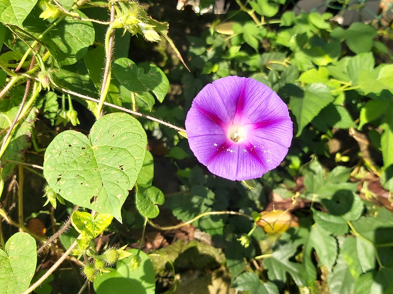
There were many beautiful purple Morning Glory 牽牛花 while we were walking passing those campsites.
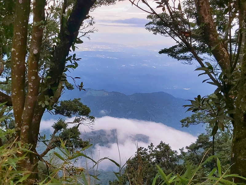
Then we reached an exposed section, and our guide Xiao Tsai told us Snow Mountain (aka Mt. Xue), Mt. Dabajian, Mt. Xiaobajian 大小霸尖山, and the whole Holy Ridge were presented in
front of us.
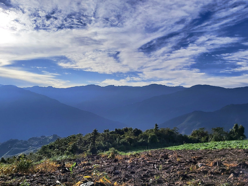
It was almost impossible to contain my excitement when seeing the Holy Ridge, because I just did Mt. Dabajian
and Mt. Xiaobajian two weeks prior to this hike.

After the short admiration of the Holy Ridgeline, we entered a small opening in the bush and started to go
uphill.

Within 40 minutes, we reached Mt. Niaozui. I also saw the bright yellow sign saying Wufeng Skyline Trails with
millage of 16.5K. The sign also said the total distance between Shangping 上坪 and Guanwu 觀霧 was 28.5K .

There were 10 peaks on this trail, and Mt. Niaozui was the 6th one. You can see 10-6 on the peak plate. There
were two triangulation stones on the peak of Mt. Niaozui.

Watching Mt. Jiali from Mt. Egongji
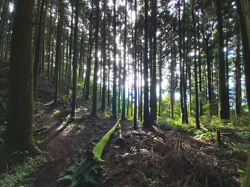
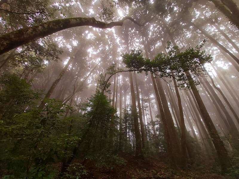
There wasn't much to see on Mt. Niaozui, so we continued our hike. From here, we entered the Japanese Cedar
forests, just like those I saw when I did on Mt. Xiangtianguan and Mt. Guangtiangao.
My knees still hadn't totally recovered from the previous day, and I was tired already from climbing uphill.
So, I became the slowest one in the group.

After passing the sign of 15.5K, the trail became mild, and I could finally catch my breath. One of the
benefits to hike with a responsible hiking group is there is always a guide to keep company with the last
hiker. There was not exception this time. A female guide kept me company. After a while, the female guide
needed to do her business, so I continued to hike. I was temporarily alone on the trail, and I loved it.

Once in a while, the beams of sunlight seeped through the dense trees, and something hanging in the air caught
my attention. It was a big, delicate spider web. The owner of this beautiful home was nowhere to be seen, but
it was kind enough to let me enjoy its home.

Soon enough, I caught up with the hiking mates ahead of me, and we hiked in the cedar forests for a while
before entering the jungle vegetation. The terrain became rugged again.

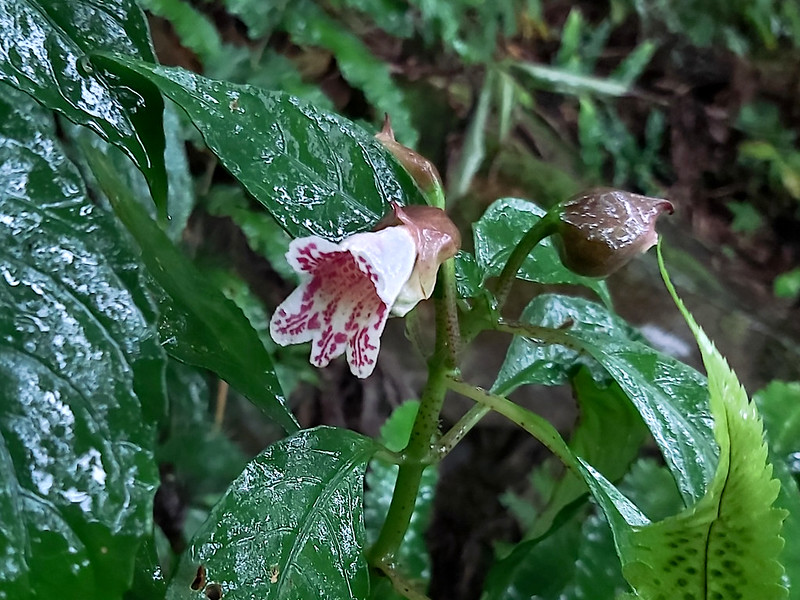
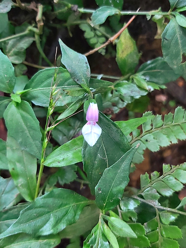
While gradually slowing down my pace, I noticed something white on the side of the trail. There were several
interesting looking flowers with two petals, the pinkish top and the white bottom. I did some research, and my
guess was they were Peristrophe japonica (Thunb.) Bremek 九頭獅子草.
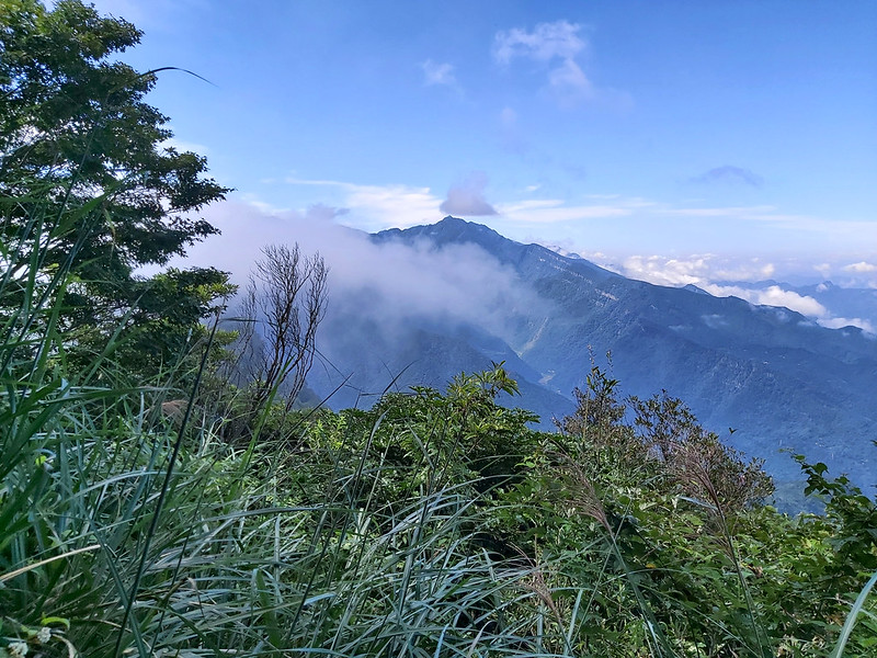
After passing 12.5K sign, we hiked on the ridge. I could see the mountains hugged by the fluffy clouds rising
from the valley.
Then, I passed a junction with several big signs pointing to another trailhead inside Shan Shang Ren Jia Farm
Resort.

Within a few minutes, I reached Mt. Egongji.

There wasn't much to see on the peak of Mt. Egongji. However, please don't be fooled by this, because there
was a small footpath that will lead you to a great delight.

My hiking mates were kind enough to point out the direction for me to go. I quickly put down my backpack and
hurried up to the slope. I was lucky enough to get a glimpse of Mt. Jiali from the distance before the clouds
claimed the views again.
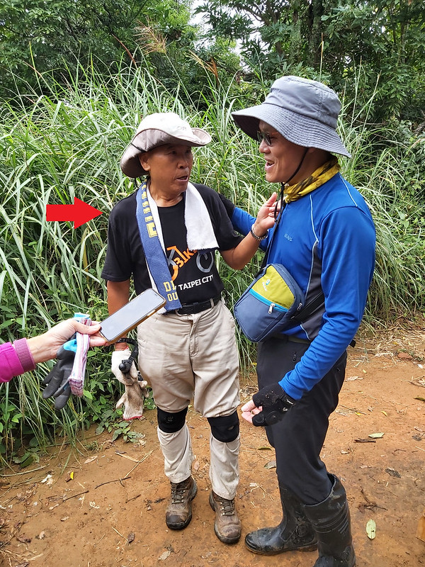
When I returned to the triangulation stone, the rest of our hiking mates had already arrived. There were other
hikers on the peak as well. Among them, a male hiker caught everyone's attention. He told us that he was
already 86 years old. But he was not the only surprise we saw on the trail.
Mt. Egongji Northeast Peak in Japanese Cedar Trees
After we left Mt. Egongji, the terrain became rocky, and we were greeted by more and more hikers coming up
from No. 1 trailhead. Many of them were from big hiking associations, but there were also many small children
accompanied by their parents. I was surprised and curious, so I asked how old they were. Many of them were
preschoolers.
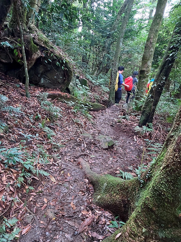
Then, I met the one that might be the youngest on the trail, a cute little girl who was 3 years old. Those
kids were incredibly, no whining or complaining. One of their parents told us they were there for a group
activity. I wish I could start hiking when I was a small kid.

After the rough terrain, we entered the Japanese Cedar forests again for our last peak, Mt. Egongji Northeast
Peak, which mean more steep slopes were waiting for us.

Finally, Mt. Egongji Northeast Peak. This peak was surrounded by Japanese Cedar Trees and nothing much to see
at all.

While finishing Mt. Egongji, I'd been thinking about whether I should continue my hike to other peaks. To be
honest, every step made my knees hurt. On the way to No. 1 trailhead, we could see the ridgeline of the
afternoon hike, Mt. Wuzhi 五指山. The ridgeline did look like a raised fist. One of the peaks there is called Mt.
Zhongzhi, literally meaning middle finger in Chinese.

When we finally exited the trailhead, we stayed at a small deli shop to have some food. I decided to call it a
day along with some hikers who also suffered knee pains. This was not my very proud moment, but it was for
sure I wouldn't enjoy the rest of the hike if my knees were still hurt.
Thoughts about this Hike and Other Routes
I can't keep track of how many routes you can do to connect those peaks. Some people do it in one day with a distance of 40km and cumulative elevation gain and loss up to 4,000
meters.
The following is a list of routes you can do to enjoy the beautiful trails here. Just pick up those that suit
you the best and remember, safety first.
Finish 10 Peaks in 2 Days, Suggested by LOHAS
Here's how our group, LOHAS, did it. We stayed at a B&B near Guanwu before the hike and at Bagun B&B
and Campingsite for the second night.
Day 1: Start at 6.5k of Leshan Forest Road ➔ Mt. Lukeng 鹿坑山 ➔ Mt. Nanbilin 南比林山 ➔ Mt.
Bilin 比林山 ➔ Mt. Dawo 大窩山 ➔ Octagon Pavilion 八角亭
Day 2: Octagon Pavilion ➔ Mt. Niaozui 鳥嘴山 ➔ Mt. Egongji 鵝公髻山 ➔ Mt. Egongji Northeast Peak
鵝公髻山東北峰 ➔ Mt. Daiai 大隘山 ➔ Mt. Wuzhi (5 peaks) 五指山連峰 ➔ Mt. Shangping 上坪山
Suggested Routes by A Complete Guide to Hsinchu Wufeng Skyline Trails
I got permission from A Complete Guide to Hsinchu Wufeng Skyline
Trails 新竹五峰天際線完全攻略 to translation the routes. Most of the following are loop hikes.
- From Shangping 上坪 to 9.5k at Leshan Forest Road 樂山林道 to connect the ridgelines among those 10 peaks. This is a point-to-point hike, and you need to arrange pickups.
- From Shangping 上坪 to Guanwu Police Station 觀霧派出所 via Leshan Railway Track and Taiwan Cypress trail. This is an advanced version of point-to-point hike to connect those ten peaks. You need to arrange pickups.
- Loop hike of 10-1, 10-2, and 10-3: Mt. Shangping, Mt. Wuzhi and Mt. Daiai
- Loop hike of 10-4, 10-5, and 10-6: Mt. Egongji Northeast Peak, Mt. Egongji and Mt. Niaozui
- Loop hike of 10-7, 10-8, 10-9, and 10-10: Mt. Dawo, Mt. Bilin, Mt. Nanbilin and Mt. Lukeng. You need to get to Sinpitu Tribe (Lu lake or Luhu) in Nanzhuang 南庄鹿湖 via Tertiary Road Miao 21 苗21 to Mt. Niaozui at Dawo Tribe
- Loop hike of 10-1, 10-2, 10-3, 10-4, 10-5, and 10-6
- Loop hike of 10 peaks
- Loop hike of Bi Da Niao 比大鳥O型: Start from Qingquan 清泉 to the trailhead is at 2.5K of Dalu Forest Road 大鹿林道, and take Bailan River Old Trial 白蘭溪古道 and Qingquan Old Trail 清泉古道.
- Loop hike of three Bilins 三比連走O型: Mt. Bilin Northeast Peak 比林山東北峰, Mt. Bilin 比林山, and Mt. Nanbilin (South Bilin) 南比山.
- Point-to-point hike of Mt. Egongji and Mt. Niaozui (E Niao Loop) 鵝鳥縱走O型 - Nanzhuang virsion: from Donghe to Dawo Tribe.
- Loop hike of Shihbi, Mt. Dawo, and Mt. Niaozui, (Shih Da Niao Loop) 石大鳥O型: From Shihbi to Mt. Mt. Dawo and Mt. Niaozui to Dawo Tribe.
- Loop hike of Shih Lu 石鹿連走O型: from Shihbi to Mt. Dawo, Mt. Bilin, Mt. Nanbilin and Mt. Lukeng to Luhu.
- Two big loop hikes in Nanzhuang 五峰天際線之南庄兩大O繞: Loope hike of Shihbi and loop hike of Shih Lu mentioned above.
- Loop hike starting counterclockwise at 4K of Taiwan Cypress Trail 檜山巨木群步道 (also at 6K of Leshan Forest Road 樂山林道) to Mt. Lukeng 鹿坑山 via Leshan Railway Track 樂山鐵道, and back to 9.5K at Leshan Forest Road.
Finish 10 Peaks in 3 Hikes, Suggested by A Complete Guide to Hsinchu Wufeng Skyline Trails
-
Hike 1 of 10-1 to 10-3: Mt. Shangping, Mt. Wuzhi and Mt. Daiai
Start from the trailhead near Guanhui Temple 廣惠宮 that is next to Hi-Life Convenient Store 萊爾富超商 on Taiwan County Highway (122 縣道 122 or 南清公路). There is a bus stop, Rueifong Elementary School 瑞峰國小, next to Hi-Life Store and you can check out Hsinchu Bus 新竹客運 5628, 5630, 5630A to see how to get there.
You'll find the trail to Mt. Shanping ➔ Mt. Wuzhi (Zhongzhi Peak, aka Middle Finger Peak) ➔ Mt. Daiai ➔ Township Road Chu 67 (竹67鄉道) ➔ No. 1 Trailhead of Mt. Egongji (don't go up to Mt. Egongji). Follow Township Road Chu 67 to Wuangye Lodge Kara Karaoke Restaurant 荒野山莊卡拉OK餐廳 and to the bus stop Chu Jia Zhuang 朱家莊 on Taiwan County Highway 122 and take Hsinchu Bus 新竹客運 5628, 5630, 5630A to Hsinchu Train Station. -
Hike 2 of 10-4 to 10-6: Mt. Egongji Northeast Peak, Mt. Egongji and Mt. Niaozui
From No. 1 Trailhead of Mt. Egongji ➔ Mt. Egongji Northeast Peak ➔ Mt. Egongji ➔ Shan Shang Ren Jia Farm Resort ➔ junction to Mt. Niaozui ➔ Mt. Niaozui ➔ junction to Mt. Niaozui Campsite. Don't take Mt. Dawo ➔ go downhill about 1 kilometer back to Mt. Niaozui Campsite ➔ Octagon Pavilion. From Octagon Pavilion, you can arrange a pickup or go downhill on the road to Zhang Xueliang Culture Park 張學良文化園區 (about 9.5K) to take Hsinchu Bus 新竹客運 5628, 5630, 5630A back to Hsinchu Train Station. -
Hike 3 of 10-7 to 10-10: Mt. Dawo, Mt. Bilin, Mt. Nanbilin and Mt. Lukeng
Arrange a pickup and get off at Octagon Pavilion near Mt. Niaozui. From Octagon Pavilion ➔ Mt. Niaozui Campsite ➔ Mt. Dawo ➔ Mt. Bilin ➔ Mt. Nanbilin ➔ Mt. Lukeng ➔ reach the fence of Leshan Base 樂山基地 (a transmitter base) at 9.5K of Leshan Forest Road ➔ Guanwu Lookout, 6K at Leshan Forest Road ➔ Guanwu Taiwan Cypress Trees Trail ➔ somewhere between 1k and 2K at Leshan Forest Road ➔ Miyue Trail (Honeymoon Trail) 蜜月小徑 ➔ Guanwu Tourist Center 觀霧遊客中心. Arrange a pickup to wait at Guanwu Tourist Center.

Finish 10 Peaks in 2 Hikes, Suggested by A Complete Guide to Hsinchu Wufeng Skyline Trails
-
Hike 1 of 10-1 to 10-6:
Trailhead near Guanhui Temple 廣惠宮 that is next to Hi-Life Convenient Store 萊爾富超商 ➔ Mt. Shangping ➔ Mt. Wuzhi (Zhongzhi Peak) ➔ Mt. Daiai ➔ Township Road Chu 67 (竹67鄉道) ➔ No. 1 Trailhead of Mt. Egongji ➔ Mt. Egongji Northeast Peak ➔ Shan Shang Ren Jia Farm Resort ➔ junction to Mt. Niaozui ➔ Mt. Niaozui Campsite junction. Don't go to Mt. Dawo ➔ back to Mt. Niaozui Campsite ➔ Octagon Pavilion. Arrange a pickup to wait for you at Octagon Pavilion. -
Hike 2 of 10-7 to 10-10:
Arrange a pickup and get off at Octagon Pavilion near Mt. Niaozui. From Octagon Pavilion ➔ Mt. Niaozui Campsite ➔ Mt. Dawo ➔ Mt. Bilin ➔ Mt. Nanbilin ➔ Mt. Lukeng ➔ reach the fence of Leshan Base 樂山基地 (a transmitter base) at 9.5K of Leshan Forest Road ➔ Guanwu Lookout, 6K at Leshan Forest Road ➔ Guanwu Taiwan Cypress Trees Trails ➔ somewhere between 1K and 2K at Leshan Forest Road ➔ Miyue Trail (Honeymoon Trail) 蜜月小徑 ➔ Guanwu Tourist Center 觀霧遊客中心. Arrange a pickup to wait at Guanwu Tourist Center.
Since there are many routes, it's easy to get lost here. It's better to have a map or GPS tracks with you
before you hike. I hope you will enjoy those hikes.
If you have read this far, here's a video clip of bird chirping that I recorded on the trail. Please turn on
your volume to enjoy it.
Have you been to the mountains in Hsinchu? What do you think about this trail to Mt. Egongji and others? Will
you do all the mountains? Please leave comments below. Don't forget to subscribe to newsletters to know more
about the exciting trails in Taiwan.
Map and Itinerary
Group Hike or Solo Hike: Group hike with LOHAS
Date of Hike: September 20, 2020
Date of Hike: September 20, 2020
Route map for Mt Egongji, Mt Egongji Northeast Peak, Mt. Niaozui by Anusha Lee on plotaroute.com
Click Menu in the map to download, print or share the map.
Click to change the speed to meet your
condition.
to change the speed to meet your
condition.
Note:
My GPS track may not be totally accurate and is for reference only.
Click
to change the speed to meet your
condition.Note:
My GPS track may not be totally accurate and is for reference only.
Based on my hike on September 20, 2020
06:22
Arrived at Octagon Pavilion
06:40
Started the hike and passed the campsites
06:53
Arrived at the entrance in the bush and enjoyed the view of Holy
Ridge
07:20
Saw 16.5K sign and arrived at Mt. Niaozui
07:52
Passed the junction to Octagon Pavilion
08:01
Saw 15.5K sign
08:33
Passed 14.5K sign
08:55
Passed 13.5K sign
09:25
Passed 12.5K sign
09:40
Passed 12K sign
09:48
Arrived at Mt. Egongji and took a break
10:11
Left Mt. Egongji
10:21
Passed 11.5K sign
11:11
Reached Mt. Egongji Northeast Peak
11:49
Reached pavement path and saw Mt. Wuzhi in the distance
11:53
Arrived No. 1 Trailhead of Mt. Egongji
Total time:
5 hours 13 minutes, including long breaks
Recommended Blogs and Resources:
Chinese only:
Hiking Biji: Hsinchu Wufeng Skyline Hikes 新竹五峰天際線
Hsinchu Wufeng Skyline Hikes Part 2 of 4: Mt. Egongji Northeast Peak, Mt. Egongji and Mt. Niaozui 新竹五峰天際線四之二:鵝鳥縱走 (鵝公髻山東北峰-鵝公髻山-鳥嘴山)
10 Peaks of Wufeng Skyline Hikes in One Day 一日五峰天際線(爬升近4千)挑戰路線
Loop hike of Mt. Niaozui and Mt. Dawo in Wufeng Hsinchu 新竹縣五峰鄉鳥嘴山、大窩山 O 行來回
English posts:
Mt. Niaozui and Mt. Egongji: 五峰天際線 鳥嘴山-鵝公髻山
Mt. Niaozui and Mt. Egongji: 五峰天際線 鳥嘴山-鵝公髻山