Tefuye Historical Trail and Mt. Zhizhong: A Trail That Lets You Get A Glimpse of Highest Peak in Northeast Asia
Tefuye Ancient Trail or Tefuye Historical Trail is a beautiful trail near Alishan. It's very relaxing to hike
on the old railway track in the beautiful Japanese Cedar Trees. To spice things up, we did the challenging
hike to Mt. Zhizhong and saw Jade Mountain aka Yushan on the peak. This is a hike that can range from being
easy to tough.


Table of Contents:
- About Tefuye Historical Trail and Mt. Zhizhong
- How to Get There
- Peaks to Reach
- Take the Challenging Part to See the Highest Peak in Northeast Asia
- The Hike Became More Difficult After Mt. Zhizhong
- The Easier Part of Tefuye Historical Trail
- Some Thoughts about this Hike: How to Make This Hike More Enjoyable
- Map and Itinerary
- Recommended Blogs and Resources
- Related Posts on Taiwan Hikes
About Tefuye Historical Trail and Mt. Zhizhong
Many people probably have heard of Alishan, one of the most beautiful attractions in southern
Taiwan. Zhizhong and Tefuye Trail are right next to Alishan and close to each other, but Zhizhong is in Nantou
County and Tefuye Historical Trail is located in Alishan.
The total length of Tefuye Historical Trail (aka Tefuye Ancient Trail) is 6.32 km
(3.93 miles), and it used to be a hunting trail for indigenous the Cou (or Tsou) people 鄒族, who have resided in Alishan for
generations. During Japanese occupation, Japan government rebuit this trail for timber tansport.
Mt. Zhizhong used to be named after the fourth of Japanese Governor-General 總督, Kodama Gentaro 兒玉源太郎, called
Mt. Eryu. Later, President Chiang Kai-shek changed the name after General Zhang Zhizhong, who fought hard
during the Second Sino-Japanese War. Aside from the history, the peak of Mt. Zhizhong is a great place to see
Mt. Yu ridgeline.
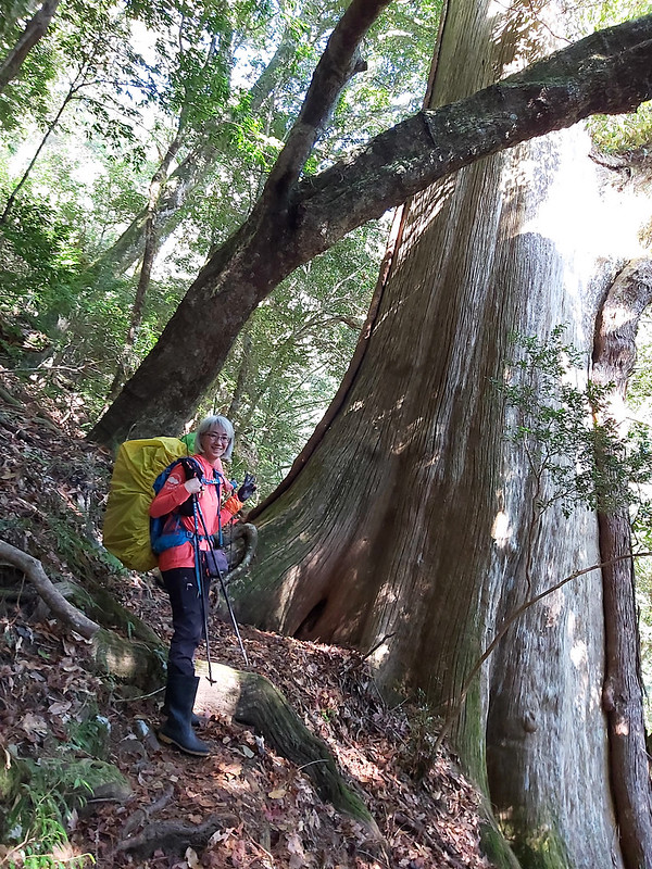
This is a point-to-point route and you can find toilets on both sides of trailhead. It's easier to hike from
Zhizhong side, which is flat. There are wood stairs on the other side. There are many tall Japanese Cedar
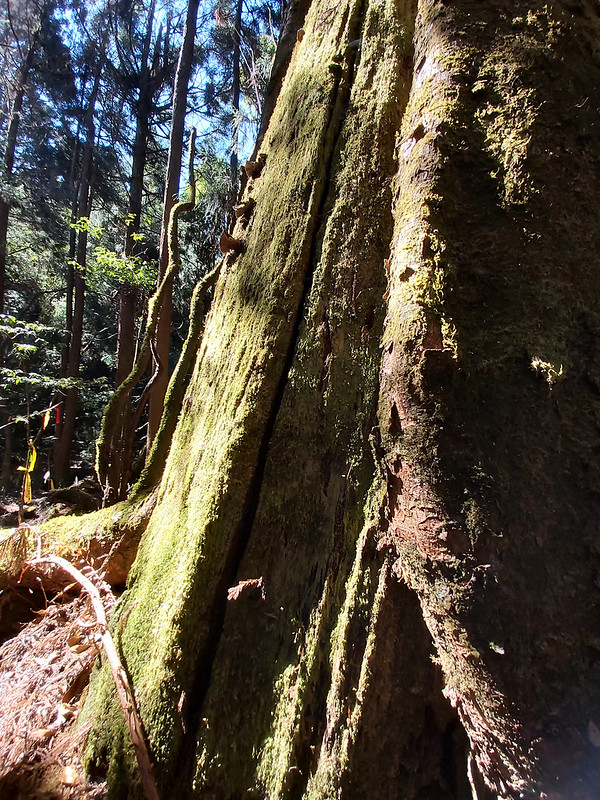
Trees here. Walking on the old rail track and being surrounded by those tall beautiful trees is very relaxing.
2026 Alishan Itinerary Guide
The hardest part of Alishan isn't the hiking — it's getting there and sorting things out. My 2026 Alishan itinerary guide maps out the whole trip by bus — 1, 2 & 3 days — in English. It's just $5, and it saves you hours of piecing together scattered, half-outdated posts.
How to Get There
There's only one bus to get here,
Yuanlin Bus 6739, and this bus runs between Sun Moon Lake and Alishan. If you
plan to
visit Sun Moon Lake and have some extra days, it will be great to
put Tefuye and Alishan in your itinerary.

After getting off at Zhizhong Stop, you will find the trailhead of
Tefuye Historical Trail and public toilets. Some hikers camp near the old police station building so they can
see the sunrise or start the hike to Mt. Zhizhong early.
Peaks to Reach
Mt. Zhizhong, aka Mt. Eryu: 自忠山 or 兒玉山, Zhizhong Shan,
2,606 meters (8,550 feet). Views are very good on the peak.
Mt. Beixia: 北霞山, Beixia Shan, 2,472 meters (8,110 feet). No views.
Mt. Dongsui: 東水山, Dongsui Shan, 2,611 meters (8,566 feet). No views.
Mt. Beixia: 北霞山, Beixia Shan, 2,472 meters (8,110 feet). No views.
Mt. Dongsui: 東水山, Dongsui Shan, 2,611 meters (8,566 feet). No views.
Take the Challenging Part to See the Highest Peak in Northeast Asia
We left Taipei at 8:00 pm on the previous evening and stayed at the hotel where was around two hours to the
trailhead of Tefuye Historical Trail on the Zhizhong side.

Start with the Location Where Hikers Can see Sunrise
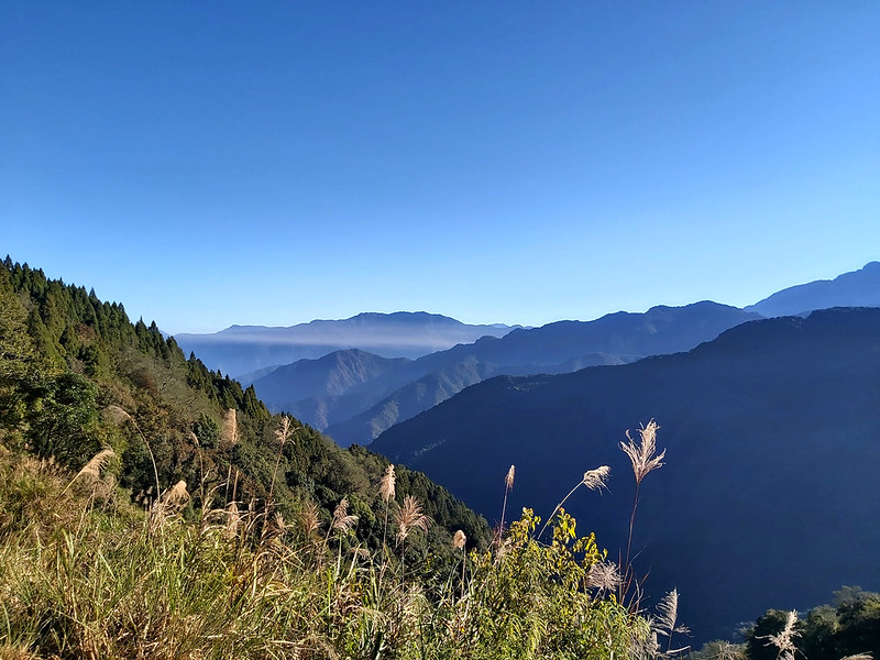
The first thing caught my eye was the layers of mountains in the
valley. Our guide told us this was a great spot to see the beautiful
sunrise if you camp nearby. If the clear sky and the mountains we
witnessed at that moment was already astonishing, I couldn't imagine
how stunning it would be if I could get a chance to see the sunrise.
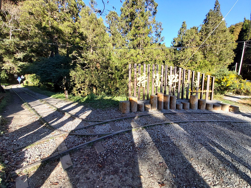
The entrance of Tefuye Historical Trail was very easy to recognize and
there was an old railway track going all the way inside this area. All you have to do is just follow the
railway track. There were many cedar trees and the trail was very flat.
Happy Hour Was Over. Embrace the Steep Slopes.
After a few meters, our happy time was over, because we had to go to Mt. Zhizhong from here. To demonstrate
its authority, the trail gave us a very sharp steep beginning. A little warning before you
decide to take this trail: this trail is considered as a high altitude hike, and the high altitude will make
the breathing a little bit more difficult if you aren't used to it.

I learned this lesson in the hard way during this hike. Our group left
Taipei late on the previous evening, and by the time we got to our B&B, it was 1 am already.
We had to get up at 5 am, which means we only had less than 4 hours
to sleep. But sometimes your sacrifice will pay off. When we were
about to leave our B&B, I realized we were surrounded by mountains
and Mt. Yu was one of them.

I wasn't feeling well on that week already. So, those things
together made my hike even more miserable.

Beautiful Mt. Yu Range from Mt. Zhizhong Peak
Our first peak was Mt. Zhizhong, 2,606 meters (8,550
feet). The trail condition was quite rugged but not too bad, because most parts were
covered by pine needles. We reached a place that was big enough for
all of us to take a rest, and left our backpacks here before
climbing up to Mt. Zhizhong.

Just when I thought the previous sections of trail were steep
enough, it was even steeper on the way to Mt. Zhizhong. Luckily, it
didn't take us long to get there.
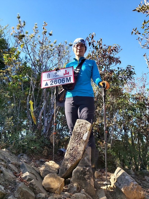
I looked the other side from the peak and our guide told us that
that was the highest mountain in Taiwan, Mt. Yu, 3,952 meters (12,966 feet).
The stunning view made me feel instantly better for a few minutes.

The view from the opposite side of Mt. Yu was also spectacular. I
stood there for a while to admire the landscape around me.

2026 Alishan Itinerary Guide
The hardest part of Alishan isn't the hiking — it's getting there and sorting things out. My 2026 Alishan itinerary guide maps out the whole trip by bus — 1, 2 & 3 days — in English. It's just $5, and it saves you hours of piecing together scattered, half-outdated posts.
The Hike Became More Difficult After Mt. Zhizhong
We still had several peaks to go. Our next stop was Mt. Dongshui. The
trail became steeper again, and my excitement soon was replaced by
fatigue. I noticed that the higher altitude we hiked, the
more amazing trees we saw. Our guide reminded us that logging was
the main business in Tefuye many decades ago.

I'm no expert of vegetation, but you still can tell the forest was
mixed with pines and subtropical trees, which was quite normal in higher attitude mountains in Taiwan. They
just blended together so well.

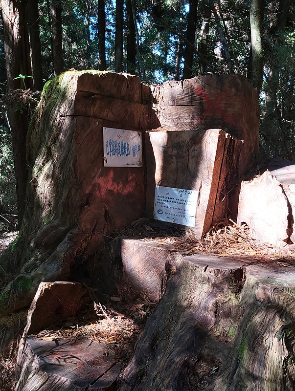
While hiking on the trail and enjoying the beautiful trees, I noticed
some big trees were brutally chopped down and there were signs on
them. I went up close to check out those signs. The signs said those
trees were the victims of illegal logging, and those crimes were
under investigation. This wasn't my first time seeing this. Illegal
logging is still a serious issue in Taiwan. The government promises
they will relax the restrictions on hiking in Taiwan and encourage
hikers to report poachers if seeing them. I truly hope this will help reduce illegal logging.
I also saw there were many acorns on the trail. Our guide told
us those were acorns of Ring-cupped Oak trees 青剛櫟. Those seeds
are one of
Formosan Black Bears'
favorite foods. But you don't need to worry that you will run into those bears. Formosan Black Bears are
endangered species
in Taiwan. It's very difficult to see them on the trails. Seeing
those also reminded me of Scrat in the movie, Ice Age.

It took us around one hour to reach Mt. Dongshui, 2,611
meters (8,566 feet), but there was no view near the triangulation stone, so we headed to our next peak, Mt.
Beixia. After Mt. Beixia, we had to take the same route back to Mt. Donshui again.

Mt. Beixia, 2,472 meters (8,110 feet), was lower than Mt.
Dongshui, and the round trip from Mt. Dongshui to Mt. Beixia took me
4 hours to finish. This section wasn't an exciting hike without many beautiful views even though there was a
Class 3 Triangulation Stone. My pace was getting slower and slower, especially during the ascending.

Before my first arrival at Mt. Dongshui, I found myself
huffing and puffing, and I had to stop almost every few meters to
catch my breath. A very friendly guide, Fion, was very kind to keep
company with me. I even asked Fion whether there was any exit
on the trail so I could leave the trail early. Unfortunately, no.
On the way back to Mt. Dongshui, I was so exhausted that I had
to stop every three steps. I did difficult hikes
before, but i never experienced things like this. I was dead tired.
I got disoriented sometimes that I missed the trail. So, Fion
decided to take the lead.
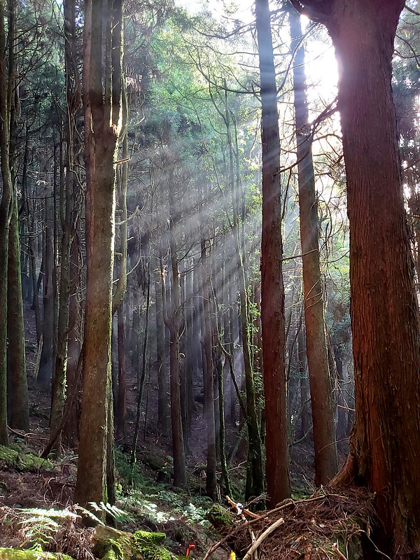
Fion was in a much better condition than mine, and I felt so
terrible for her that she had to slow down for me. I remember I even
fell asleep within seconds during a break when I leaned on my
backpack. When opening my eyes again, I was amazed by the beautiful
sunshines dancing in the woods. So, I took this picture.
There was still a long way to go and we had to move fast, so I didn't take many photos afterwards. By the time
we finally left
the rugged terrains, it was already dark. Luckily, we also reached
Tefuye Historical Trail again and it was easier to hike. It was pity that I
didn't get to see this part of the trail in the broad daylight, but
it didn't matter at that moment. It started raining and we just
wanted to get back to our bus.

We put on our headlamps and continued to hike. We still had the
final 2 km (1.2 miles) to reach the trailhead. It was almost pitch
dark and the only thing I could see was the rain drops flying through my
headlamp.

This final section took me almost one hour to finish, but it felt
like forever. Although I was very slow, I wasn't the last one to
finish our first-day hike. There were around 7 people behind us, and
it took them another two hours to finish the hike. For me, I was
glad that I could call it a day.
The Easier Part of Tefuye Historical Trail
It's a shame that I didn't get to see those trees on the easy part
of the trail. From the photos taken by my hiking mates, those trees
were gorgeous. For those who just want to enjoy strolling without
too much stress, you can find some information at
Tefuye Historical Trail from Forestry Bureau website.

Thoughts about This Hike: How to Make This Hike More Enjoyable
I will do this hike again, but I will also change the
route to make the hike more enjoyable.
First, I will leave Taipei earlier if possible. We left Taipei
at 8 pm and we arrived at our B&B around 1 am, which took us
around 6 hours to Alishan area.

Second, I will camp at old Zhizhong Police Station, a red building next to the Tefuye trailhead, to reduce the
commuting time. Sorry I didn't take the photo. The policemen no long station here. Some hikers camp here to
save time. It took us almost 2 hours from our B&B to Tefuye Old Trail. If we could camp there, we could have
slept more and even seen the sunrise. Our guides arranged B&B for us hoping that we could sleep better, but we
could only sleep around 4 hours, which didn't help much.
Third, I probably will skip Mt. Beixia, make it a point-to-point
route, and take the same route back to where we start, and spend
more time to enjoy Tefuye Old Trail.
Fourth, during our hike, I saw many maple leaves on the trail, and
the color was still amazing. If you enjoy seeing the rare fall foliage in Taiwan, I think you can arrange this
hike in autumn.

I still highly recommend this trail, as long you can avoid my
mistakes, or just take the easy one and enjoy the unique landscapes
and the history behind the trail. After this, you can also visit
Alishan and
see more spectacular views over there.
Here's
my second day hike
from this trip.
Have you been to Alishan? Are you also looking for other places to visit in Alishan? If so, Tefuye is for you.
Please leave comments below and subscribe to newsletters for more amazing trails in Taiwan.
Map and Itinerary
Group Hike or Solo Hike: Group hike with
Taiwan
Mountain LOHAS Association (LOHAS)
Date of Hike: November 30, 2019
Date of Hike: November 30, 2019
Click Menu in the map to download,
print or share the map.
Click to change the speed to meet your condition.
Note:
Due to GPS accuracy setting, there may be some difference between my GPS tracking and the exact distance. Please check the infographic above for the more accurate data.
Click
to change the speed to meet your condition.
Note:
Due to GPS accuracy setting, there may be some difference between my GPS tracking and the exact distance. Please check the infographic above for the more accurate data.
Based on my hike on November 30, 2019
05:30
Got up, had dinner and took the bus at 6:30 to the
trailhead.
08:00
Arrived at the trailhead in Zhizhong, took group photos and
got ready
08:18
Started the hike
08:21
Started the steep slope
09:05
Reached the rest area before hiking up to Mt. Zhizhong. We
left our backpacks there.
09:20
Reached Mt. Zhizhong and took photos
10:23
Reached Mt. Dongsui
11:55
Reached the tree that was hacked down by illegal logging. Had
lunch somewhere.
13:14
Arrived at Mt. Beixia
14:55
Back to Mt. Dongsui. I wasn't feeling okay so I didn't make many
notes from here.
18:16
Back to Tefuye Old Trail
18:56
Finished the hike and got back to our bus
Total time:
10 hours 56 minutes, including breaks
2026 Alishan Itinerary Guide
The hardest part of Alishan isn't the hiking — it's getting there and sorting things out. My 2026 Alishan itinerary guide maps out the whole trip by bus — 1, 2 & 3 days — in English. It's just $5, and it saves you hours of piecing together scattered, half-outdated posts.