Syakaro Historic Trail: A Hike with History, Suspension Bridges and Fall Foliage
Syakaro Historic Trail, aka Xiakelo Historic Trail, is the most popular hike to see the beautiful fall foliage
in Taiwan. Besides its unique nature, this trail used to have an enormous amout of outposts during the
Japanese Occupation. So if you are looking for a trail full of history, views, and stunning landscapes near
Hsinchu, this one is for you.


Due to typhoons and heavy rains, some Syakaro or Xiakelo Historic Trail sections might be closed. Please check
Forestry Bureau's website to make sure the trail is open
before you go.
Disclaimer:
All content is for inspiration only. Use Taiwan Hikes' suggestions at your own risk. We are not responsible for any losses, injuries, or damages.
All content is for inspiration only. Use Taiwan Hikes' suggestions at your own risk. We are not responsible for any losses, injuries, or damages.
Table of Contents:
- About Syakaro Historic Trail: The First National Trail in Taiwan
- How to Get There and How to Plan Your Hike
- Peaks and Places to Reach
- Day 1: A Trail with Many Beautiful Suspension Bridges
- Day 2: Very Easy and Downhill Hike to the Other Trailhead
- Thoughts about this Hike and Other Trails Nearby
- Map and Itinerary
- Recommended Blogs and Resources
- Related Posts on Taiwan Hikes
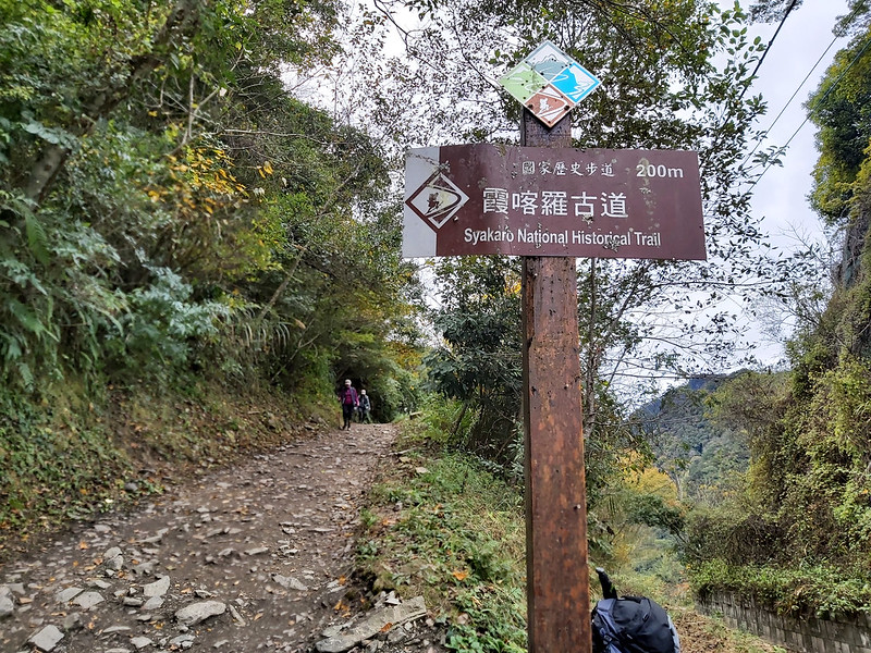
About Syakaro Historic Trail: The First National Trail in Taiwan
Syakaro or Xiakelo Historic Trail (I'll use Syakaro on this post because it's Atayal language) is a
trail between Wufeng Township and Jianshi Township in Hsinchu County, Taiwan. It is also the first National Trail (Chinese) finished and
opened to the public in 2003 and attracted many hikers to witness the beauty and history of Syakaro. However,
when Typhoon Mindulle struck Taiwan in 2004, the floods and landslides destroyed this trail, and Syakaro was
closed again.
In December 2018, it was finally opened to the public again and became one of Taiwan's most famous historic
trails.
Syakaro means Formosan Michelia 烏心石 in the Atayal
language, and there were a lot of these trees near the headwater of the Touqian River 頭前溪 in this area. Around
250 years ago, a group of Atayal people moved here, and this tribe was named after Syakaro.
A Trail with the Highest Outpost Density to Control Atayal People
According to Xu Rulin, the author of A Story of the Xiakalo Historic Trail,
the total length of Syakaro was 49.2 km (30.6 miles). Nowadays, the north and south sections of the trail have
been transformed into modern roads. So, the total length of the Syakaro Historic Trail is only 22 km (13.7
miles).

Like Zhuilu Old Trail, Syakaro Historic Trail was also paved by blood. During the Japanese
Occupation, the Japanese government used this trail to suppress the indigenous people, Atayal, which ignited two Syakaro Incidents 霞喀羅事件.
According to Dr. Lee Ruizong 李瑞宗, there were 25 outposts built on the trail to
repress Atayal People, almost one outpost every 2 km, which made Syakaro have the highest outpost density
among the trails during that time. Now, most outposts are gone, and very few are well-preserved.

From Syakaro Trail to Mt. Dabajian and the Holy Ridgeline
In August 1927, a group of Japanese hikers with their indigenous Atayal guides started from Syakaro Trail.
They took several Cautionary Paths/Security Paths (this is the translation I saw on the signs, but I think it
means Security Paths) 警備道路 and reached Madala River Trailhead 馬達拉溪登山口, which is the trailhead to Mt.
Dabajian 大霸尖山 today.

Those Japanese hikers successfully reached the top of Mt. Dabajian (which is not allowed now). However, Mt.
Dabajian was deemed a sacred mountain in Atayal culture, those Atayal guides only stayed at the base.
When one of the Japanese hikers, Numai Tetsutaro 沼井鐵太郎, reached Mt. Yizhe 伊澤山 3,297 meters (10,817 feet) and
looked at the spectacular ridgeline from Mt. Xue to Mt. Dabajian, he acclaimed this ridgeline as Holy Ridge (aka Shengleng
Trail) 聖稜線. This is where the Holy Ridge came from and climbing the Holy Ridge has become a hikers'
dream ever since.

How to Get There and How to Plan Your Hike
There is no public transport to get to either trailhead. No buses are allowed to get to the trailheads. You
either hire a van with a driver to take you to one of the trailheads and wait for you to finish at the other,
or have a group of friends driving two cars and hike from both ends and exchange the car keys in the middle.
Do the Hike in One Day
AIf you are fit, doing this trail in one day is doable. To make this hike easier, please start from Shihlu
Trailhead.
Do the Hike in Two Days and Carry Your Meals and Gear
Most hikers will camp at Baishih Outpost 白石駐在所, and you will find toilets there. However, please take the used
toilet paper with you, and DON'T camp inside the old building. It's NOT allowed to camp inside the building.
But as you can imagine, it's very crowded at Baishih Outpost, and it was like a tent city when I was there.

Do the Hike in Two Days And Book On-site Catering Service
If you don't want to carry your own food, tents, and sleeping bags, you can book on-site catering service to
help you.

Peaks and Places to Reach
Shihlu Trailhead: 石鹿登山口, 1,677 meters (5,502 feet), starting at 0 km
Rope Suspension Bridge: 繩索吊橋, at 9 km
Syakaro Suspension Bridge: 霞喀羅吊橋, at 10 km
Baishih Outpost, old name Sakayachin Outpost: 白石駐在所 or 薩克亞金駐在所, 1,629 meters (5,534.5 feet), at 12 km. Sakayachin is Atayal language meaning grindstone. Baishih in Chinese means white stone, literally.
Baishih Suspension Bridge: 白石吊橋, built in 1921, at 13 km
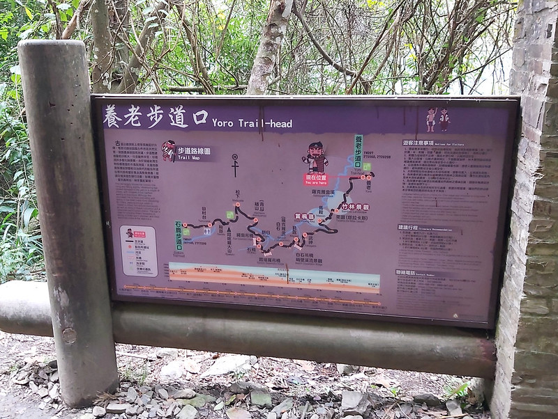
Yoro Trailhead: 養老登山口, 1,240 meters (4,068.2 feet), at 22 km. Yoro in Atayal language means a plank to prevent mice from getting inside the buildings.
Rope Suspension Bridge: 繩索吊橋, at 9 km
Syakaro Suspension Bridge: 霞喀羅吊橋, at 10 km
Baishih Outpost, old name Sakayachin Outpost: 白石駐在所 or 薩克亞金駐在所, 1,629 meters (5,534.5 feet), at 12 km. Sakayachin is Atayal language meaning grindstone. Baishih in Chinese means white stone, literally.
Baishih Suspension Bridge: 白石吊橋, built in 1921, at 13 km
Yoro Trailhead: 養老登山口, 1,240 meters (4,068.2 feet), at 22 km. Yoro in Atayal language means a plank to prevent mice from getting inside the buildings.
Day 1: A Trail with Many Beautiful Suspension Bridges
Distance: 12.3 km (7.6 miles)
Brief itinerary: Shihlu Trailhead (Height 1,677 meters) ➔ Syakaro Suspension Bridge (Height 60 meters) ➔ Baishih Outpost (Height 1,629 meters)
GPS coordinates of Shihlu Trailhead: 24.561246, 121.169258
Brief itinerary: Shihlu Trailhead (Height 1,677 meters) ➔ Syakaro Suspension Bridge (Height 60 meters) ➔ Baishih Outpost (Height 1,629 meters)
GPS coordinates of Shihlu Trailhead: 24.561246, 121.169258
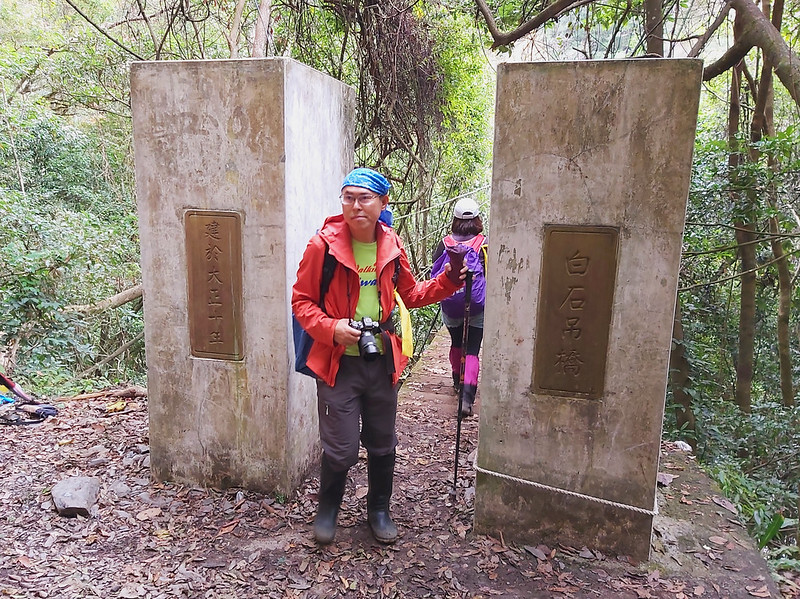
We started from Shihlu Trailhead 石鹿登山口 near Qingquan 清泉 at 10:46 am. Shihlu Trailhead is usually the one you
start if you want to do the whole trail because you will hike downhill mostly from here. You'll find many
signs and maps telling you the history and information you need to know on this trail.

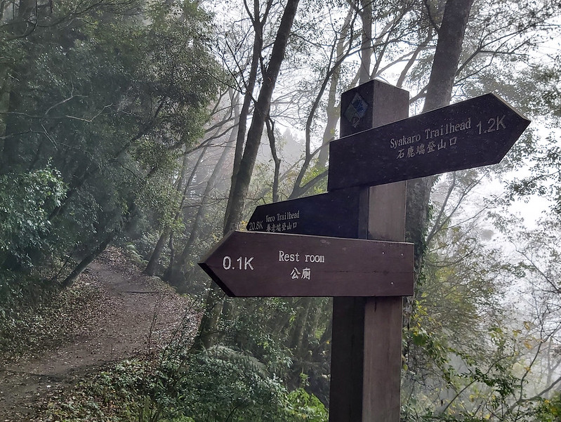
If you need to go to the toilet, there is one at 1.2 km.
The trail terrain was relatively flat and easy to hike. We were accompanied by tall and slender Japanese Cedar
Trees. It was pretty relaxing to walk there. It was a little bit cloudy when we started the hike, but we still
could see beams of sunlight seeping into the woods.

This trail is well marked, and you'll find the millage marks in increments of one kilometer.

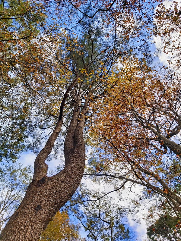
Beautiful Fall Foliage and Sea of Clouds
Autumn is the high season to hike the Syakaro Historic Trail because of fall foliage. I didn't get to see much
of it, but it was still a delight to see some bright red leaves dancing among the trees.

Because we started the hike late, we stopped soon to take a lunch break. So, I took a spot facing the slope.
At first, all I could see were trees and clouds.

Suddenly, I saw parts of the blue sky appearing in the distance. I put down my lunch, rushed to the edge of
the slope, and waited.

After the lunch break, we continued to hike. Our guides told us there was a bypass to avoid the dangerous
ridge section. I saw ropes circling the dangerous cliff, and a sea of clouds rose from the valley! I reached
the rope area, carefully not to step on the loose slope, and took photos.


After the ridgeline, we were back in the woods again. Inside the woods, the mist floated on the trail, which
made the trail look mystic.

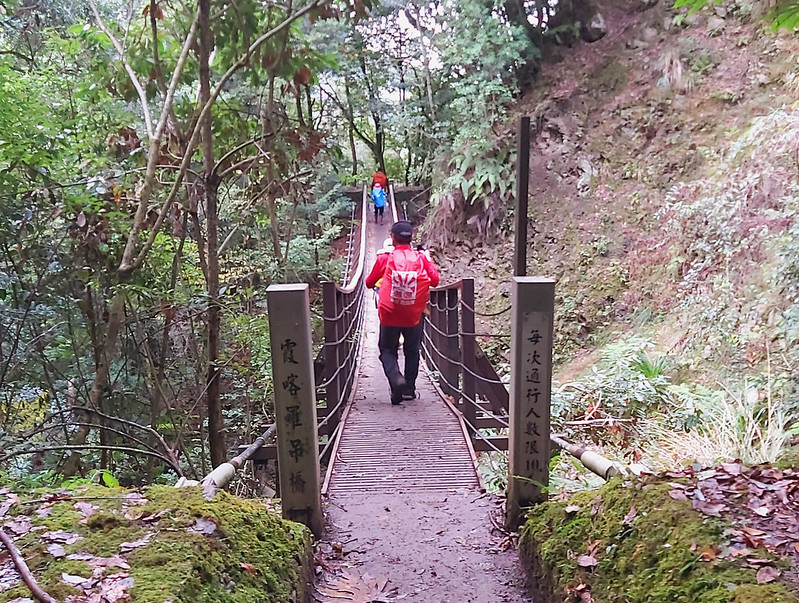
Stone Bearing Walls Left by Old Outposts and Beautiful Suspension Bridges
Then we saw some walls and signs about what those walls were. Those were stone-bearing walls left from Hanheno
Outpost 楢山 (青山) 駐在所, 1,980 meters (6,496 feet), during the Japanese Occupation.

The trail became rugged after this but still manageable. Suddenly, we stopped. It turned out that we had
reached the first suspension bridge, the Rope Suspension Bridge 繩索吊橋. There were so many hikers on the trail,
and it wasn't a surprise we had traffic jams. It took us 10 minutes to cross the bridge.


After 15 minutes, we saw another outpost remains, Asahi Outpost 朝日駐在所. I didn't see anything left from the old
outpost, but I saw tents set up by hikers.

If you plan to camp at Baishih Outpost and need more water, you will find a water source around 5 minutes
after Asahi Outpost. The water was clean, and I drew about 1L with my water filter.

After another 10 minutes, we reached Syakaro Suspension Bridge, our second one on the day.
Arrived at Baishih Outpost 白石駐在所
Within 20 minutes, I saw a lot of tents on the trail, which reminded me of my hike to Songluo Lake. We had arrived at our campsite, Baishih Outpost, 1,629 meters (5,534.5
feet) after passing the 11 km sign.

Please note that Baishih Outpost is an ancient building; please don't camp inside it. You'll find toilets at
Baishih Outpost, but please remember to take toilet paper with you.

Day 2: Very Easy and Downhill Hike to the Other Trailhead
Distance: 10.4 km (6.4 miles)
Brief itinerary: Baishih Outpost (Height 1,629 meters) ➔ Baishih Suspension Bridge ➔ Mawan Outpost (Height1,460 meters) ➔ Yoro Trailhead (Height 1,240 meters)
GPS coordinates of Yoro Trailhead: 24.589243,121.253694
Brief itinerary: Baishih Outpost (Height 1,629 meters) ➔ Baishih Suspension Bridge ➔ Mawan Outpost (Height1,460 meters) ➔ Yoro Trailhead (Height 1,240 meters)
GPS coordinates of Yoro Trailhead: 24.589243,121.253694
The next day, my hiking mates told me they saw a beautiful starry sky when getting up in the middle of the
night. I knew we might see that but having so many hikers around put off my desire to see the sky.
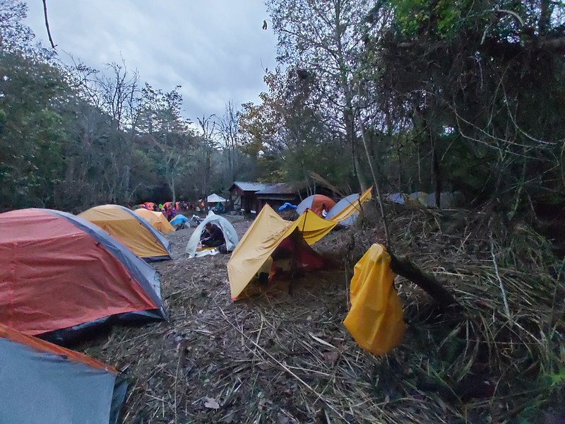
I was not surprised when the whole Baishih Outpost looked like a traditional market in Taiwan 菜市場, a metaphor
to describe the crowded places.

Baishih Suspension Bridge with Wider Bridge Hangers
The trail after Baishih Outpost was mainly downhill. After 40 minutes, we reached Baishih Suspension Bridge.
Unlike the previous ones, the gaps among those bridge hangers were much more expansive. This one may be
difficult if you are not comfortable with the height.

The Eroded Trail with Log-ladders Hanging
After crossing the bridge, there was a junction, and we took the one on the left and went downhill. Then, we
went up again on several long log ladders. In Taiwan, you will find trails paved with concrete, planks,
pebbles, or materials taken from nearby surroundings.

We took a left and went downhill at this junction. Those log ladders were phenomenal because the dirt
underneath the ladders was washed away. However, those ladders remained hanging, making climbing on them more
difficult.

Reached to the Section Where Motorbikes Could Ride
After the hanging ladders and some slightly rugged terrains, we reached 13 km, which some motorbikes could go.
From there, the trail was very flat and almost downhill.

You'll find the sign of Takegami Outpost 武神駐在所 around 14 km, but the building is nowhere to be found. Then I
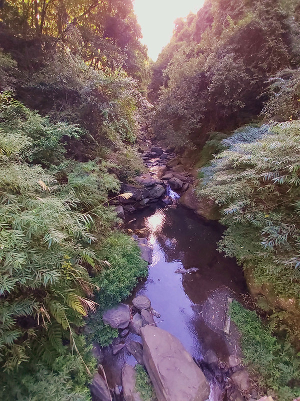
saw a small bridge over Sakeyachin Creek (aka Baishih Creek) 薩克雅金溪/白石溪, which originated from the north of Mt. Dabajian.
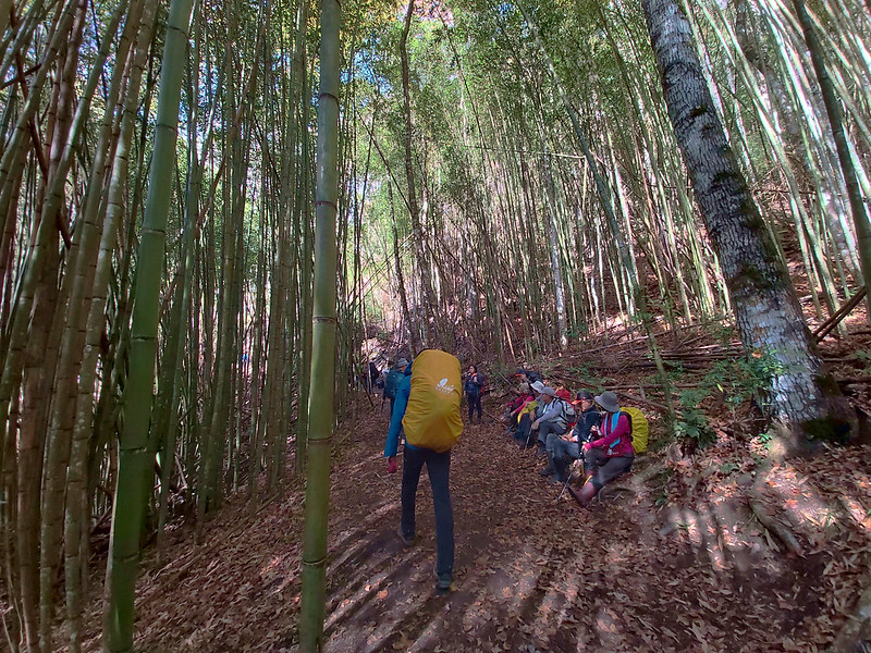
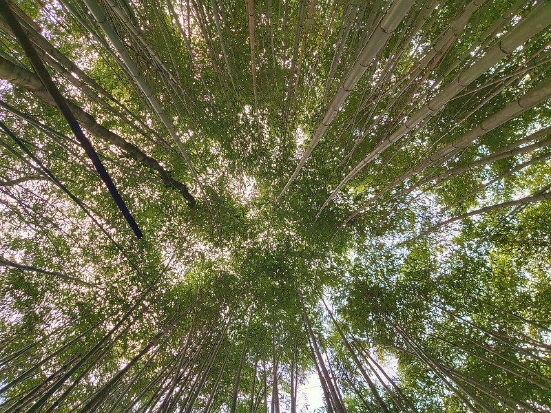
Beautiful Makino Bamboo Woods
After the bridge, I reached a section with an open view of mountains from a distance.

Within a few minutes, I arrived at the Bamboo Landscape. The Makino Bamboo is so tall and beautiful that it
has become one of the landmarks of Syakaro Historic Trail.
Inside the bamboo woods, there was Mawan Outpost 馬鞍駐在所. This outpost was named after an Atayal man who was
first here to cultivate the land. Nothing much left here, either. We took a one-hour break at Mawan Outpost.

The trees at Mawan Outpost were tall and gorgeous. The clouds and blue sky in the background made those trees
even more spectacular.
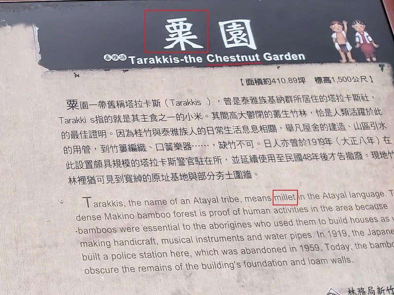
Tarakkis Outpost with A Mysterious Sign Saying Chestnut Garden
Then we found the last outpost we could see before reaching Yoro Trailhead, Tarakkis Outpost 塔拉卡斯駐在所.
According to the sign, this place was home to one of the Atayal tribes, Tarakkis, which means millet in the
Atayal language.
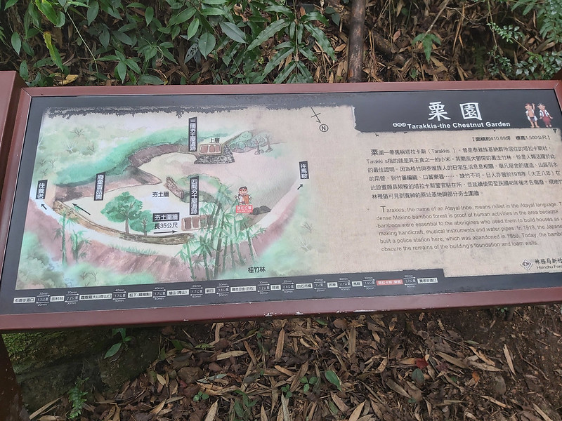
However, the sign said "Tarakkis-the Chestnut Garden." I have no idea where chestnut came from. So I Google
and found an online forum in 2019 saying the Forestry Bureau, in charge of this trail, said this was a mistake
made by the supplier, and they would correct it. Well, it's still there…
The mistake came from the Chinese fonts, a typo. The Chinese character of millet is 粟, and the pronunciation
is SU. The Chinese of chestnut is 栗, and the pronunciation is LI.
From Tarakkis Outpost, there was 3.7 km left to Yoro Trailhead, and it took 1 hour to get to the trailhead,
according to the sign. It took me 50 minutes because I got bored and wanted to return to our bus as soon as
possible.
Thoughts about this Hike and Other Trails Nearby
Several places are worth paying a visit to before the hike.
The first one is Zhang Xueliang Residence 張學良故居. General Zhang Xueliang was the instigator of the 1936 Xi'an Incident and played an essential role in China's modern
history. Long story short, he was placed under house arrest by Chiang Kai-shek for five decades, and he spent
13 years in Qingquan, Wufeng.
The second one is Sanmao's Dream House 三毛夢屋. Sanmao (pen name: Echo) 三毛 is a famous
writer and translator in Taiwan in the 1970s and 1980s, and her books, especially novels and travelling, have
influenced many generations in Taiwan.
I will put Zhang Xueliang Residence and Sanmao's Dream House on the first day's itinerary and do the hike on
the second day.
Other than visiting those places, there are peaks I'd like to hike. Mt. Syakaro, aka Mt. Shihlu, 霞喀羅大山 or 石鹿大山, 2,234 meters (7,329.4 feet).
There's a Class 3 Triangulation Stone on the peak. The entrance of Mt. Syakaro is at 3.1 km on Syakaro
Historic Trail. Unfortunately, I didn't see it when I was on the trail. Mt. Syakaro is also the watershed of
Sakeyachin Creek on the east and Syakaro Creek on the west.

The second mountain I'd like to add to my itinerary is Mt. Bunujiali 布奴加里山, 2,125 meters (6,971.8 feet), and there is also a Class 3
Triangulation Stone on the peak. According to other hikers, the views on Mt. Bunujiali are great. The entrance
to this mountain is 16.3 km before reaching Mawan Outpost. But this one is more challenging. The cumulative
elevation gain is 1600+ meters.
Have you been to Syakaro? What do you think about those beautiful suspension bridges and outposts? Please
leave comments below. Remember to subscribe to newsletters to learn more about Taiwan's exciting trails.
Map and Itinerary
Group Hike or Solo Hike: Group hike with Dudu
Date of Hike: December 19 and 20, 2020
Date of Hike: December 19 and 20, 2020
Click the Menu in the map to download, print, or share the map.
Click to change the speed to meet
your condition.
to change the speed to meet
your condition.
Note:
The GPS track is for reference only. This GPS track source is here, and this one goes to Mt. Syakaro.
Click
to change the speed to meet
your condition.Note:
The GPS track is for reference only. This GPS track source is here, and this one goes to Mt. Syakaro.
Day 1: based on my hike on December 19, 2020
10:46
Arrived at Syakaro Shihlu Trailhead
11:06
Reached the toilet at the 0.1km sign
11:36
Reached the 2km sign
11:49
Took a 40-minute lunch break
12:33
Reached the cliff to see the sea of clouds
13:26
Reached the 5km sign, and the trail became very flat
13:48
Saw the first Stone-bearing wall and took a 10-minute
break
14:55
Reached Rope Suspension Bridge and it took 10 minutes to
pass
15:24
Reached Asahi Outpost at 10k
14:40
Reached Syakaro Suspension Bridge
16:02
Reached Sakayachin (Baishih) Outpost and campsite at 12.2k
Total time:
5 hours 16 minutes, including long breaks
Day 2: based on my hike on December 20, 2020
07:40
Left Baishih Campsite
08:21
Reached Baishih Suspension Bridge
08:26
Arrived at a junction and took the left one
08:39
Reached the eroded log stairs
09:19
Reached the section where motorbikes can reach
09:25
Reached Takegami Outpost
09:33
Reached the 15km sign
09:49
Reached the bridge over Sakeyachin Creek
09:57
Reached Bamboo woods
10:06
Reached Mawan Outpost and Maple Viewing Area at the 15km
sign
10:21
Took one hour break
11:28
Reached the 17km sign
11:46
Another Bamboo landscape again
11:51
Reached Tarakkis, the misnamed chestnut garden
12:40
Reached Yoro Trailhead at 22km
Total time:
5 hours, including the one-hour and small breaks
Recommended Blogs and Resources:
Chinese only:
Hiking Biji: 霞喀羅國家步道 Syakaro HisToric Trail
Tony Huang: [新竹尖石].霞喀羅古道(養老段) Syakaro Historic Trail: Yoro Section
霞喀羅國家步道
霞喀羅古道: local business for hotel, guided tours and meals
新竹五峰: 霞喀羅古道 順登霞喀羅大山、布奴加里山 Syakaro Historic Trail, Mt. Syakaro, and Mt. Bunujiali
陽明山腳下的法蘭克: 新竹縣五峰鄉清泉部落張學良故居-三毛夢之屋-環山步道-天主教堂 Sanmao's Dream House and Zhang Xueliang Residence