From Smangus to Qilan: A Trail to See Holy Ridgeline and More
This is a hike starting from the beautiful indigenous village, Smangus, to Qilan in Yilan. You'll see the most
spectacular sunrise, striking tall trees, and Holy Ridgeline. Then, you will enter a different world full of
mosses and the final virgin forests in Taiwan.


Disclaimer:
All content is for inspiration only. Use Taiwan Hikes' suggestions at your own risk. We are not responsible for any losses, injuries, or damages.
All content is for inspiration only. Use Taiwan Hikes' suggestions at your own risk. We are not responsible for any losses, injuries, or damages.
Table of Contents:
- About Smangus and Qilan
- How to Get There
- Peaks and Places to Reach
- Day 1: The Easy Part: A Pleasant Strolling among Smangus Old Trees
- Day 1: The Challenging Hike with Rugged Terrains
- Day 2: From Wonderful Sunrise to Tree Cemetery and Ended with Misty World
- The Risks on the Trail: Three of Us Fell or Almost Fell of the Slopes
- Thoughts about this hike
- Map and Itinerary
- Recommended Blogs and Resources
- Related Posts on Taiwan Hikes
About Smangus, Qilan and Yuanyang Lake Nature Reserve
Beautiful Atayal Village: Smangus
Smangus, 1,620 meters (5,315 feet) above the sea level, belongs to indigenous Atayal People, and is located in Jianshih Township, Xinchu City in Taiwan. It was so remote that Smangus didn't
have electricity till 1979. Therefore, it was once called Dark or Black Village. Now, it's
called God's Village after Smangus has become a tourist attraction, which suits Smangus way much better than
the prejudiced one.

The majority of Smangus people choose a different lifestyle by adopting
cooperative community to ensure all the members in this village are paid equally and well taken care of, when
more and more tourists are visiting. If you are interested to know more about their liefstyle, please check
out Erv's post or Smangus' website (Chinese only)
for more details.

I recommend you stay at Smangus village to have a cup of tea or coffee and enjoy the amazing surroundings
before you start your hike. Smangus' tranquility and grit reveal a special quality which is unique among most
indigenous villages. Perhaps the disadvantaged location helps Smangus perverse her beauty and make their
people one of a kind.

Please note that you might need to apply for permit during some high seasons, like cherry blossoms. Please
check out Smangus' website for more information.
Qilan
As to Qilan, you'll need to apply permit
from National Police Agency at least 3 days in advance to enter Qilan Giant Trees area. The name of the
destination is 100 林道 (宜蘭-大同鄉). The Google translation on the website is 100 Forest
Road (Yilan County - Datong Township).
There is a Cilan (Qilan) Forest Recreation Area, which is famous for
primeval forest, is not the one we hiked on this trail, but this is a great place to visit if you just want to
have a relaxing trip.
Please note that hikers can only take the trailhead from Smangus to Qilan, not the other way around for safety
reasons.
Yuanyang Lake Nature Reserve
One thing worth mentioning is Yuanyang Lake Nature Reserve 鴛鴦湖自然保留區, loacated on Mt. Xue
Range 雪山山脈 on the borders of Hsinchu 新竹, Taoyuan 桃園 and Yilan 宜蘭, and the area of this reserve is 374 hectares
(924 acres). The maximum depth of Yuanyang Lake is 15 meters, the area of the lake is 3.6 hectares (8.9
acres), and is 1,670 meters (5,479 feet) above the sea level.

This place is NOT open to the public, only for academic research only. It's amain to protect the precious Sparganium fallax Graebner 東亞黑三稜, which was discovered in
Taiwan in 1972. If you hike this trail, you might get a cance to see this lake from the distance from the
trail.
How to Get There
Smangus is in a very remote part of Jianshih Township in Xinchu City. There is no public transportation to
Smangus. You have to drive or hire a car to get there. There are some traffic controls on the way to Smangus.
The car you hire must be familiar with the traffic to Smangus.
Peaks and Places to Reach
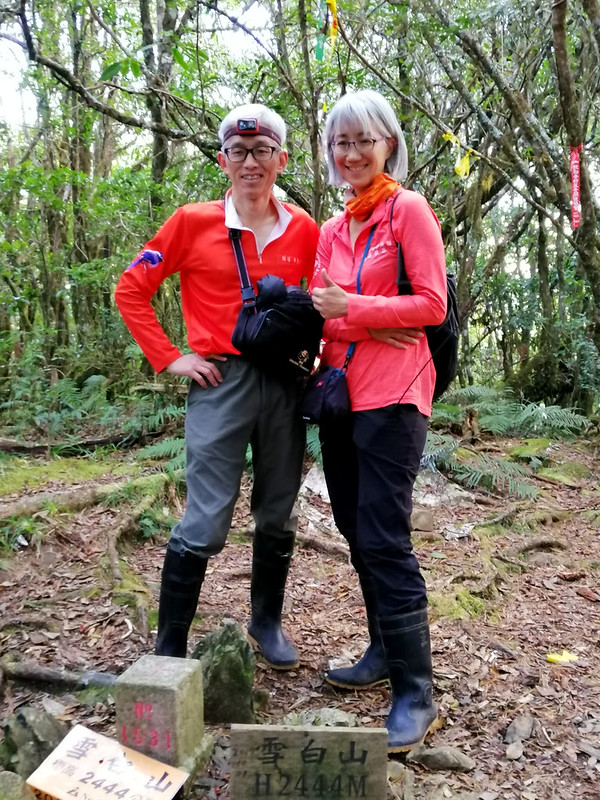
Mt. Xuebai: 雪白山, 2,444 meters
(8,018 feet), no views
Mt. Shichushi: 西丘斯山, 2,427 meters (7,962 feet), a great place to see sunrise.
Xuebai Campsite: 雪白營地, 2,050 meters (6,725 feet), and the distance from Smangus trailhead to this camp is around 7.9 km (4.9 miles). There is a water source near the campsite and the round trip to the source is 20 minutes.
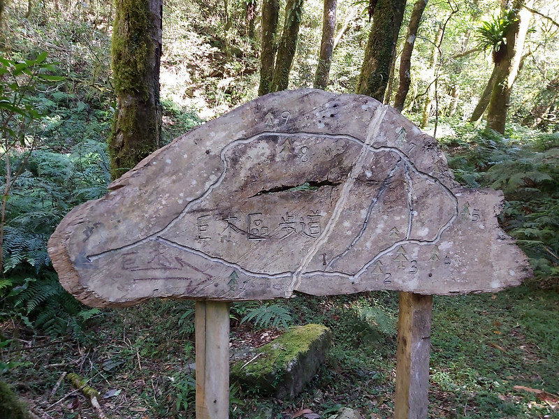
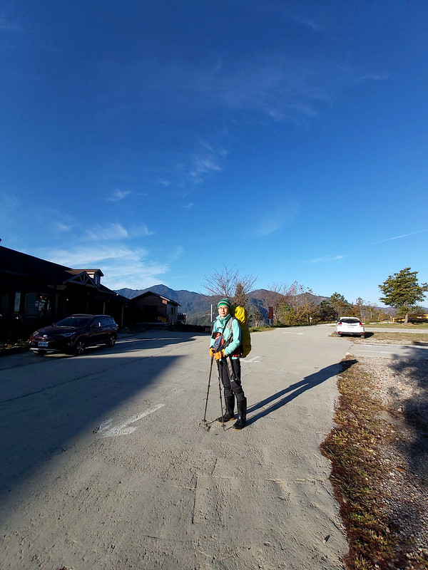
Day 1: The Easy Part: A Pleasant Strolling among Smangus Old Trees
GPS coordinates of the trailhead: 24.577818, 121.337632
I joined Taiwan Mountain LOHAS Association for this hike in January 2020. We stayed at
a nearby B&B and got up early to get to the trailhead. It was still early when we arrived in Smangus. The sky
was blue like deep ocean without any cloud, but the early sun
warmed us up in the cold weather.

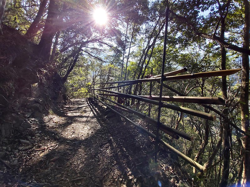
Relaxing Bamboo Woods and Magnificent Big Trees
After letting some of our hiking mates taking photos, our guide Acer
led us pass through the arch to start the hike. The first things we saw was the photogenic valleys and
beautiful slender bamboo woods, which tempted us to stop and take photos again.

It's very relaxing to stroll here.

The trail condition was surprisingly good. It was very flat and easy to hike. The trail from the entrance to
the old tree area was taken care of by Smangus people, and you could tell they had done a
tremendous job, not many annoying uneven stairs and the trail condition was kept very natural. It was such a
delight to stroll here.
You will see the old tree area approaching when you get close. Those
trees were so tall, huge, and handsome.
The oldest one in Smangus,
Yaya Qparung, meaning Mama Big Tree in Atayal language, is said to be the
second oldest tree in Taiwan, around 2,000 years old. It takes 20 people holding hand in hand to circle the
tree. As you can imagine, Yaya Qparung is the most popular photo taking spot.


The distance from the trailhead to Yaya Qparung is 5.2 km (3.2
miles), and you take the same trail back if you don't plan to go to
Qilan.
Day 1: The Challenging Hike with Rugged Terrains
After Yaya Qparung, the easy hike was over, and the trail condition
became more rugged as we started going uphill. The rugged terrains
are very common on the trails in Taiwan, especially among Mid-elevation
Mountain Trails 中級山.
By the way, if you have a better suggestion to translate 中級山, please kindly let me know.

The tree roots were intertwined with each other and we had to get a
hold of the roots to lift ourselves up. I could almost hear my
quadriceps muscles whining. Even though the trail was not easy, the
beautiful woods and the great weather still gave me some comfort.

After one hour, we reached a creek and it was time for lunch.
I sat on a big rock to boil water to make hot chocolate. While waiting for my drink, I scrutinized the
surrounding, the calming creek flowing through the forests with mixed tall trees and bushes. We were very
lucky to hike here with such a great weather.
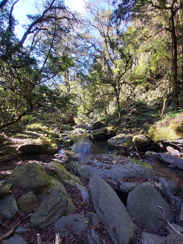
Perhaps it wasn't a bad idea just sitting here all day.

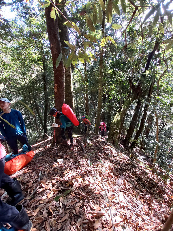
The trail condition became steeper, and we had to climb several big
slopes with fallen rocks scattered around the trail. Our guide Acer took some time to teach us how to
recognize the ridges and what we should do if we get lost in the woods.

There were many big tall trees on this section of trail. Although those were not as famous as others in
Alishan, I was still in awe, imaging all those years they have been there and all those sunshine and storms
they have
been trough.

Scary Sidehill That Brought Back My Nightmare
Then we made a turn to a very narrow sidehill. Hiking on a
narrow sidehill trail isn't anything new to me, but what made me
panic was it was on a very steep slope without many trees to grab.
In July 2017, I fell off a sidehill trail and landed
hard on the
riverbank. I was lucky to get away from serious injuries only
with nasty bruises and little scrape, but this experience has
haunted me for a while.
While hiking on this sidehill, I leaned to the slope closer
and closer and I could feel my heartbeat racing faster than normal. I was
too scared to stand upright, so I gradually squatted down and used
my left hand to keep my balance instead of my tracking poles.

I was so slow that I had to let my hiking mates pass me, and I ended
up being the last hiker in the group. The guide who acted as a
keeper was very nice and kept me company. I thought about taking
more photos of this part of the trail, but I was too panic to do
that.

Reached Xuebai Campsite
Finally, we reached our campsite, Xuebai campsite 雪白營地, 2,139
meters, (7,017 feet), and we started to pitch our tents and tarps.
This campsite probably could accommodate 40 people. There was a
water source nearby, and the round trip took around 20 minutes. I
didn't go because I had brought enough water.

After some rest, we headed to Mt. Xuebai 雪白山, 2,444 meters (8,018 feet), which was in between Taoyuan and
Hsinchu, and also the
highest peak in Taoyuan. But I turned back after a few meters. I
guess I was still in shock after the scary sidehill and nothing much to
see on the peak also put me off. So, the keeper guide and I got
back to the campsite to enjoy the quiet moment and got some rest.
Day 2: From Wonderful Sunrise to Tree Cemetery and Ended with Misty World
We got up around 3:30 am and headed to Mt. Xiqiusi 西丘斯山, 2,427
meters, (7,962 feet) around 4:10 am to see the sunrise, only carrying
the essentials, because we would return to the campsite later.
I guess we accidentally woke up bees and they
weren't very happy about that. As a result, several of us got stung. I got stung on my left cheek and it hurt
so much that I
could feel one teardrop rolling down on my cheek immediately. If you ask me, I will tell you leeches are way
much cuter than bees and other bugs on
the trails.

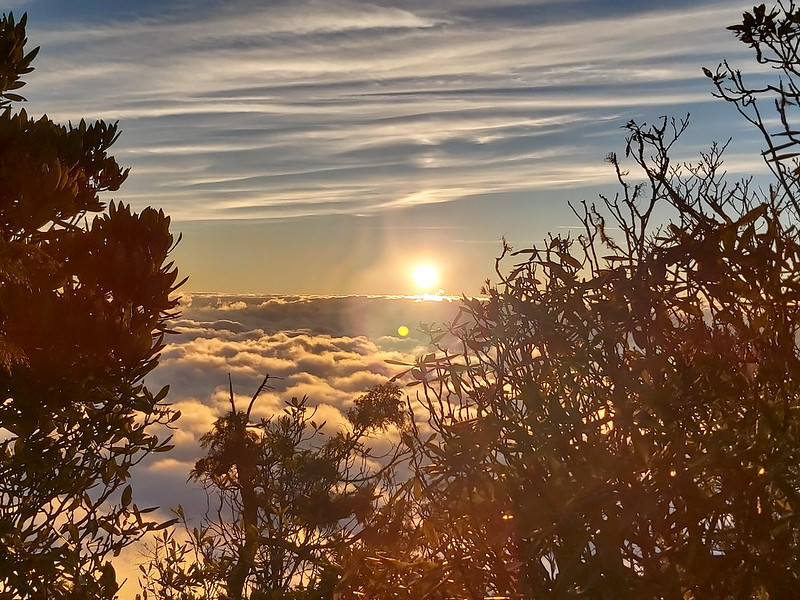
Holy Ridgeline: Mt. Dabajian Bathing in the Orange Hue
Some part of the trail shared the same one to Mt. Xuebai, which was
a very steep, and I had to put up with the pain of the bee sting. By
the time we almost got to the peak of Mt. Shichushi, I could see the
sky was getting brighter through the trees. I was so nervous that we
would miss the sunrise. Luckily, we arrived on time. When we reached
the cliff, the most astonishing nature wonder was presented in front
of us.

And the sea of clouds.
When I was soaking in and trying to enjoy this stunning view
quietly, my excited hiking mates kept talking loudly and sharing
food. This is one of the drawbacks to hike with a group. Looking on
the bright side, at least, we were the only group on the peak,
otherwise we would have to take turns to sit there.

I found a small trail in the bushes near the cliff so I decided to explore. Then, this was what I saw.
Please note that the location to see the sunrise wasn't exact the
peak of Mt. Shichushi. We had to move toward the cliff a little bit to
enjoy the stunning views.

When I turned around, our guides told us the Holly Ridgeline Trail
聖稜線, including Mt. Xue Main Peak 雪山主峰, 3,886 meters (12,749 feet) and Mt. Dabajian 大霸尖山, 3,490 meters (11,450
feet), was on the other side. The morning sunshine casted an orange hue on Mt. Dabajian and
nearby mountains, and it was so spectacular.
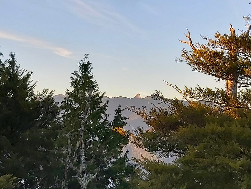
Mt. Dabajian was on my hiking list, and I finally did this hike in September, 2020.

The wonderful view made me want to stay here much longer, but we
still had a long way to go. We got back to our campsite, took our
gear, and continued the rest our hike. Then, the reality struck
again. The rest part of the trail was more demanding than the
previous ones.

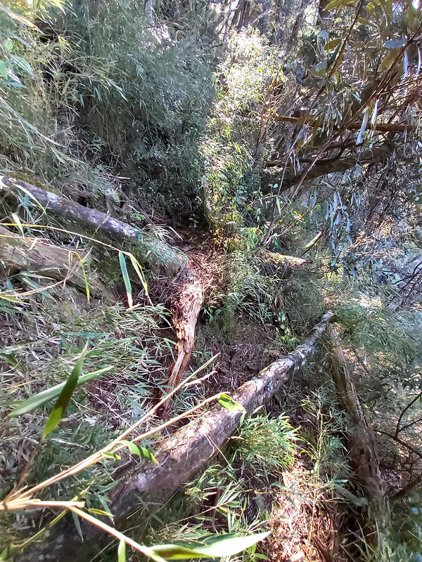
The Trail from Hell: Tree Cemetery
Other than those tall standing trees, those fallen ones lying on the
trail were so big and the number of them was so many in an
astonishing way that I felt like crying whenever I had to climb over
or crawl underneath them. From time to time, I was questioning
myself why I put myself in this situation.

Our guide told us that this area was nicknamed as Taiwan Cypress
Cemetery. From those fallen trees, it was indeed a tree cemetery.

Some fallen trees were very big and blocked the whole sidehill we
had to pass. Some of them were very thick, I had to bear hug the
tree trunk with my arms and legs stretching out as much as I could,
let my toe of my right foot touch the other side of the trail,
shifted my weight over there and landed myself safely. I thought
about asking Fion, who was on the other side helping me, to take
photos of me hugging the tree, but I changed my mind
because it might be dangerous for her.

Up to See Holy Ridgeline Again and Valley Covered by Clouds
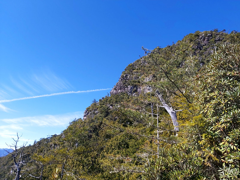
After the sidehill section, we turned up to an even much higher
sidehill without much shade, but the scenery totally opened up with
mountains circling the valley. Those mountains were the peaks on Holly Ridgeine Trail. Instead of the orange
hue in the early morning, the
Holly Ridgeline Trail stood there with the ocean blue sky in the
background, hugging the valley and the sea of cotton-like white
clouds above it. Our guide Acer knew that we wanted to
savor this moment, so he let us take a break.

Although it was January and we were on high altitude, the sun still
made us feel like it was summer.
After getting our feet back on the trail, we passed a junction, and the
other trial would lead us to Yuanyang Lake 鴛鴦湖. However, I didn't take photos of the junction.
While being on the trail, I looked back at the spot where we were there to enjoy the views of the sea of
clouds and Holy Ridgeline. It looked so far away.
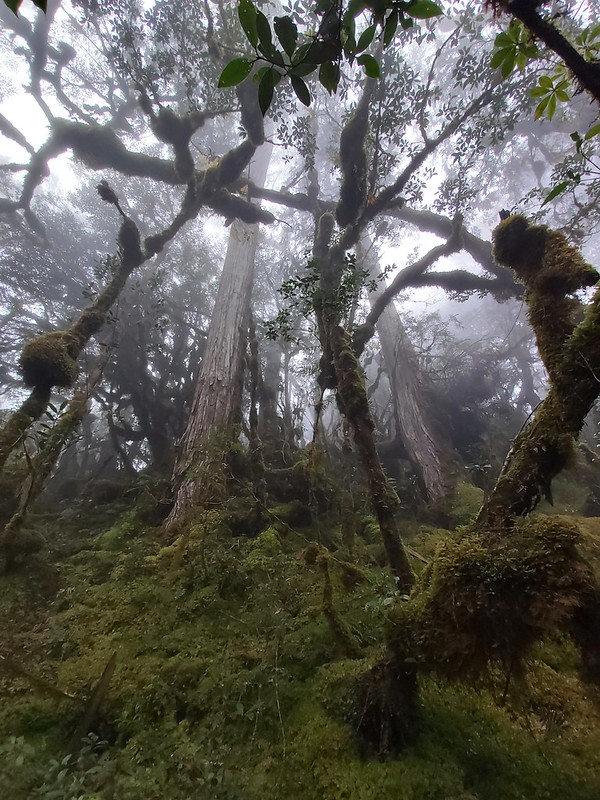
From Scorching Sun to Misty World with Muddy Trail
After passing the junction to Yuanyang Lake, we turned into a totally different
terrain which was covered by thick ferns, mosses and mud, and the weather became cloudy.

Some people say this area looks like the jungle scene in the movie
Avatar. I can't comment because I never saw that movie. Whether it's
like the scene in Avatar or not, to me, this is Taiwan. It doesn't
need to look like something else to prove its worth.

It might look dreamy to hike here, but this mushy and wet terrain
also made my legs feel like lead. I was getting out of breath and
hiking on the wet and slippery terrain wasn't making it better.

If I weren't this tired, I would love to take more photos. During
our previous break, I checked my feet and found a blister. I tended
it with bandit hoping it would make it till the end of our hike.
Obviously, I didn't do a good job and I could feel the burning
sensation.

One more photo about this amazing plant.

To make things worse, the downhill was steeper and more slippery,
and my knees were not happy about that. By the time I thought I
couldn't take it anymore, we reached the trailhead. From that point,
we just needed to walk on logging road to our hired bus, only extra
2 km left...

The Risks on the Trail: Three of Us fell or Almost Fell off the Slopes
This trail isn't labeled as Mid-elevation trail for no reasons. Some of
our hiking mates injured during the hike. The first slipped on one
slope with the big tree blocking the sidehill. Luckily, she was
stopped by trees below and managed to climb up.
The second incident was the young man in front of me. We were
descending on some wooden stairs and for some unknown reason he lost
his footing and tilted to the slope. I was
shocked by his sudden losing balance and squatted down trying to
grab his backpack. But the distance between him and me was longer
than my arm length, I could only barely pinch his backpack raincover and
dragged his raincover to the left as much as I could. Surprisingly, he
moved back to the left and regained his balance. We continued our
hike.

Later, I asked him what happened. He said he lost his footing. Then I
asked him how he got his balance back. He told me “a move” in
English. I asked again: Did you feel I was pinching your backpack
raincover? He gave me a look mixed with realization and confusion. Anyway, he was safe, which is the most
important thing.

The third incident was that a girl who wore a helmet and hiking
boots slipped off a log when we were trying to pass a gutter. She fell off about one meter and landed on her
right side. I think her helmet prevented her from possible head injury. She was shocked but suffered no
visible harm. Most of us wore rainboots. There's nothing wrong with wearing hiking boots, of course, but it's
easier to hike in Taiwan with the rainboots. Luckily, she was doing okay.

Thoughts about This Hike
If you can arrange a transportation, Smangus is a great delight to
visit, whether you take the easy strolling or the challenging trail
all the way to Qilan, Yilan. If I want to take the easy trail, I
will stay at least 2 days to enjoy this peaceful indigenous village,
taking my time and absorbing the fresh air.
If you opt for adventures, the trail from Smangus to Qilan will
certainly not disappoint you. But there are many junctions on this
trail, I don't recommend you do it alone. It's better to hire an
experienced local guide to take you there. Going with a group might
be a good option because you don't have to worry about driving or
hiring a car.
Before you go, please remember this is a physically demanding trail.
I know I tend to choose hikes that are beyond my ability, but I
think this one really kicks my butt not just because of the scary
slopes, but also the treacherous terrains. As I said, there are
dangers on some parts of the trail. Please be cautious when you
proceed.
Overall, we were very lucky to stay safe and enjoyed a lot. We saw
the most amazing views and see the mystic virgin woods. I highly
recommend people who are fit and not afraid of height to take on the
point-to-point trail, and to hike it with experienced guides. If you
ask me whether I want to hike it again, to be honest, the easy one
to see the old trees? That's for sure. The one from Smangus to
Qilan? Uh... maybe once is enough. But who knows?
Have you been to Smangus? If you are interested in indigenous culture, Smangus will be the best place to
explore. Please leave comments below. Don't forget to subscribe to newsletters to know more about the exciting
trails in Taiwan.
Map and Itinerary
Group Hike or Solo Hike: Group hike with Taiwan Mountain LOHAS Association
Date of Hike: January 4, 2020
Date of Hike: January 4, 2020
Date of Hike: January 5, 2020
Click Menu in the map to download,
print or share the map.
Click to change the speed to meet your condition.
Note:
Due to GPS accuracy setting, there may be some difference between my GPS tracking and the exact distance.
Click
to change the speed to meet your condition.
Note:
Due to GPS accuracy setting, there may be some difference between my GPS tracking and the exact distance.
Day 1, based on my hike on January 4, 2020
07:20
Arrived at trailhead from our B&B
08:11
Arrived at Big Tree Trail trailhead
10:02
Arrived at Big Tree Area
10:15
Arrived at Yaya Qparung
10:26
Resumed the hike
11:26
Arrived at the creek and had lunch
12:12
Resumed the hike
13:10
Reached the big falling rock slope
13:26
Reached another big tree area
13:57
Arrived at Xuebai campsite, drew water, pitched tents. Some
headed to Mt. Xuebai
Total time:
6 hours and 14 minutes, including breaks
Day 2, based on my hike on January 5, 2020
03:30
Got up
04:10
Headed to Mt. Xiqiusi to see the sunrise
06:04
Saw the sunrise near Mt. Xiqiusi and took photos
06:53
Reached the real summit of Mt. Shichushi
07:30
Got back to Xuibai campsite, cooked breakfast, and got ready
for the hike
08:00
Left the campsite
09:25
Reached fallen tree area
10:40
Arrived the sidehill where the video was taken to see sea of
clouds and the Holly Ridgeline Trail
11:39
Arrived at another fallen tree area and had lunch
13:56
Reached the virgin forest after passing the junction to
Yuanyang Lake
16:50
Reached the end of the trail and exited
Total time:
12 hours 40 minutes, including breaks
Recommended Blogs and Resources:
Chinese only:
Hiking Biji: 司馬庫斯古道越嶺鴛鴦湖
Hiking Biji: 司馬庫斯古道越嶺鴛鴦湖