ROMA Ridge Hike: A High Elevation Trail to See 100 Peaks and Sea of Clouds in Taiwan
A short name for ROMA trail, this is a firebreak trail between two major mountain ranges in Taiwan, Snow
Mountain and Taroko Mountain Ranges. This trail is not long, but the epic high mountain views make this hike
phenomenal. Plus, the stunning sea of clouds also enhances this hiking experience to a new level.


Table of Contents:
- About ROMA: Mt. Luoyewei and Mt. Mawuzuye
- How to Get There
- Peaks to Reach
- Steep Ascending To Mt. Luoyewei
- To Mt. Mawuzuye and Old Tree Forest
- Holy Ridge Trail (Shengleng Trail) from Mt. Mawuzuyejun
- Massive Descending with Silver Grass and Unexpected Sea of Clouds
- Thoughts about this hike: How to Improve This Hike
- Map and Itinerary
- Recommended Blogs and Resources
- Related Posts on Taiwan Hikes
About ROMA: Mt. Luoyewei 羅葉尾山 and Mt. Mawuzuye 馬武佐野郡山
ROMA is actually a short name of the ridge between two summits: Mt. Luoyewei, 2,717 meters (8,914 feet) and
Mt. Mawuzuye, 2,368 meters (7,769 feet). It's nothing to do with Roma Italy. We take the first word from those
trail names to make this trail easy to remember.

The trail isn't long, but you need to hike from elevation of 1,810 meters to 2,717 meters. Once you get to the
peaks, you will be surrounded by two beautiful ridgelines with the most famous 100 Peaks and the sea of clouds
in Taiwan. When I hiked there in December 2019, I was lucky enough to see snow-capped summits and rimes.
You need to apply permit to enter Mt. Luoyewei 羅葉尾山.
How to Get There
There are two buses going to the trailhead:
1. Take Kingbus 1751 at Yilan Transfer Station 宜蘭轉運站 and get off at Siyuan Police Station 思源派出所. It takes around 2 hours and 15 minutes from Yilang Transfer Station to Siyuan Police Station. There are only 2 buses from Yilan to Siyuan Police Station, 7:30 and 12:40.
1. Take Kingbus 1751 at Yilan Transfer Station 宜蘭轉運站 and get off at Siyuan Police Station 思源派出所. It takes around 2 hours and 15 minutes from Yilang Transfer Station to Siyuan Police Station. There are only 2 buses from Yilan to Siyuan Police Station, 7:30 and 12:40.
2. Take Kingbus 1764 at Luodong Transfer Station 羅東轉運站 and get off at Siyuan
Police Station 思源派出所. It takes around 2 hours and 5 minutes from Luodong Transfer Station to Siyuan Police
Station. There is only one bus from Luodong to Siyuan Police Station, 7:00.

However, there is no bus stop near the other trailhead after you exit the trail. If you take the bus to get
there, you'll need to walk around 5 km to get back to Siyuan Police Station stop.
Peaks to Reach
ROMA Hike means the ridgeline from Mt. Luoyewei to Mt. Mawuzuye. Hikers not only see the famous 100 Peaks like
Mt. Nanhu, Mt. Zhongyanjian and Mt. Xue Range (Holy Ridgeline Trail), but also can
enjoy the old big trees on the trail. The total hike is only 12 km (7.45 miles), but it takes at least 9 hours
to finish the hike.
Mt. Luoyewei: 羅葉尾山, 2,717 meters (8,914 feet). There is a Class 3
Triangulation Stone on the summit.
Mt. Mawuzuye: 馬武佐野郡山, 2,368 meters (7,769 feet). There is a Class 3 Triangulation Stone on the peak.
Mt. Mawuzuye: 馬武佐野郡山, 2,368 meters (7,769 feet). There is a Class 3 Triangulation Stone on the peak.
Steep Ascending To Mt. Luoyewei
GPS coordinates of the trailhead: 24.393902, 121.352493
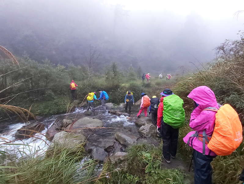
We stayed at nearby B&B, but many hikers choose to wildcamping near the trailhead at Yousheng River 有勝溪. To
get to our first peak, Mt. Luoyewei, we needed to cross the river first. Therefore, prepare some extra socks
or another pair of shoes to prevent your hiking boots from getting wet. I wore rainboots so it was easy for
me.
Starting with a Lousy Weather, but It Turned into A Big Surprise
Before we started our hike, it had been raining and cold for days, but the weather forecast said we would
have a good weather. To be honest, I didn't believe it because when we arrived at the trailhead, it was
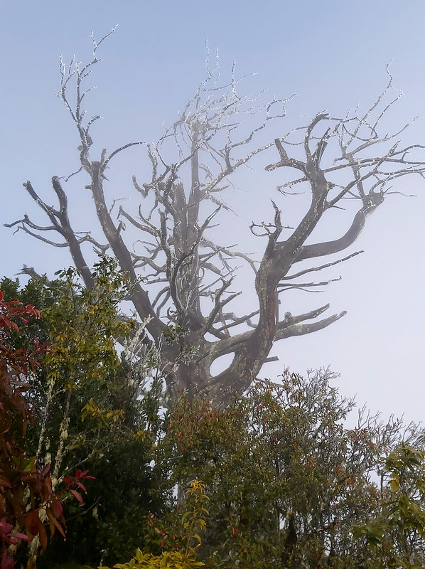
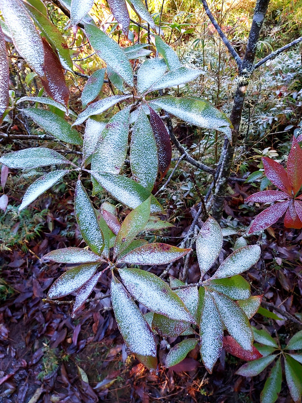
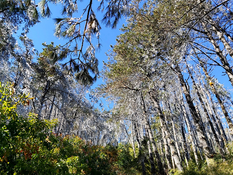
still cloudy and grey. We saw trees and branches covered by ice, caused by rain and the extremely cold
temperature. It even had been snowing on Mt. Xue for a few days. So, it was icy and cold on the trail.

To my great delight, I was totally wrong. The sky gradually cleared up and the sunshine started breaking
through the clouds. In the meanwhile, rime and clear ice on the trees started melting, too. It was like a
drizzle and we had to stop to wear our raincoats.
Occasionally, I could hear my hiking mates' happy shriek when they saw rime falling gracefully from the
trees, like fairy dust. I managed to shoot a time-lapsed video, but it still doesn't quite capture what we
witnessed right on the spot.
Apart from the rime, the mist made the trail look so mysterious.

Falling Ice Was Not Fun but ...
On a tropical island like Taiwan, it's really difficult to image how it feels like to be hit by falling ice,
but we were lucky to experience it. The melting ice not only made the trail sluggish and difficult to hike
but also made us try very hard to avoid being hit. The shriek of seeing beautiful rimes started to mix with
painful ‘Ouch, I got hit'.
We were joking that it was one in a million chance to be hit by falling ice in Taiwan. But to be honest, it
wasn't fun to be hit by this, especially those from the tall trees. Luckily, we all survived by the attack
without serious damages.
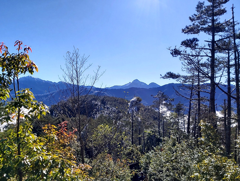
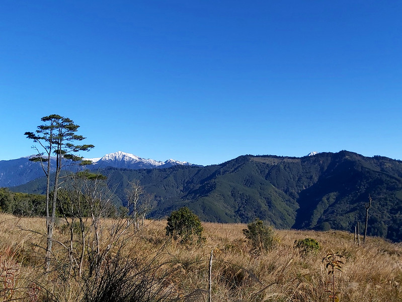
We Went above the Clouds and Saw the Snow-capped Peaks!
The slope was still very steep, and I felt my legs as heavy as lead. I had to stop frequently to catch my
breath. When I was taking a break and turned back to look where we were, I realized that the sky had been
totally cleared up, we were already above the clouds and the peaks on the other side were very clear to be
seen. Siyuan Yakou 思源啞口 was underneath clouds. The fatigue was replaced by excitement, and I hurried to hike
further, trying to get a better view.

When we reached a flat area to rest, our guides told us those peaks in front of us were Mt. Nanhu 南湖大山 3,742
meters (12,277 feet), and we could see Mt. Zhongyangjian 中央尖山 3,705 meters (12,155 feet), an almost perfect
triangle-shaped peak, if we looked to the south through the trees. Like Mt. Nanhu, the peak of Mt.
Zhongyangjian was covered by snow.
I'm not new to snow, but seeing snow in Taiwan is very rare even in high attitudes, which made me thrilled.
From time to time, we still got hit by ice, but it didn't matter anymore.

Heading to Our First Peak, Mt. Luoyewei
We still had to head to our first peak, Mt. Luoyewei. When I hiked in Norway in August 2017, we hiked at a
glacier national park and the snow was hard and as deep as the height of my knees. It wasn't an easy hike
and my hiking boots were soaking wet after a while.
Although there was no snow on this trail, hiking on the ice wasn't easy, either. It was slippery, wet and
easy to lose your footing, which is totally different from hiking on a muddy trail. I was glad that I had my
faithful trekking poles to keep me company.

Finally, we reached Mt. Luoyewei, and there were already other hiking groups queueing up for pictures.
Taking pictures with the signs on the peaks or Triangulation Stones is a big thing in Taiwan, especially the
one classified as Class 3 Triangulation Stone on Mt. Luoyewei. We waited for a while to take photos.

The sun was already high up by now, and it was hot. I took this moment to take a rest and dried my raincoat
and backpack. I sat there by myself and enjoyed the sea of clouds and the snow-capped peaks once more. The
ice was still hanging on the trees, and rimes were still falling once in a while. Those with the bright blue
sky, the cotton-like white clouds, and the green mountains circling us in the distance made my hiking
experience upgrade to a whole new level.

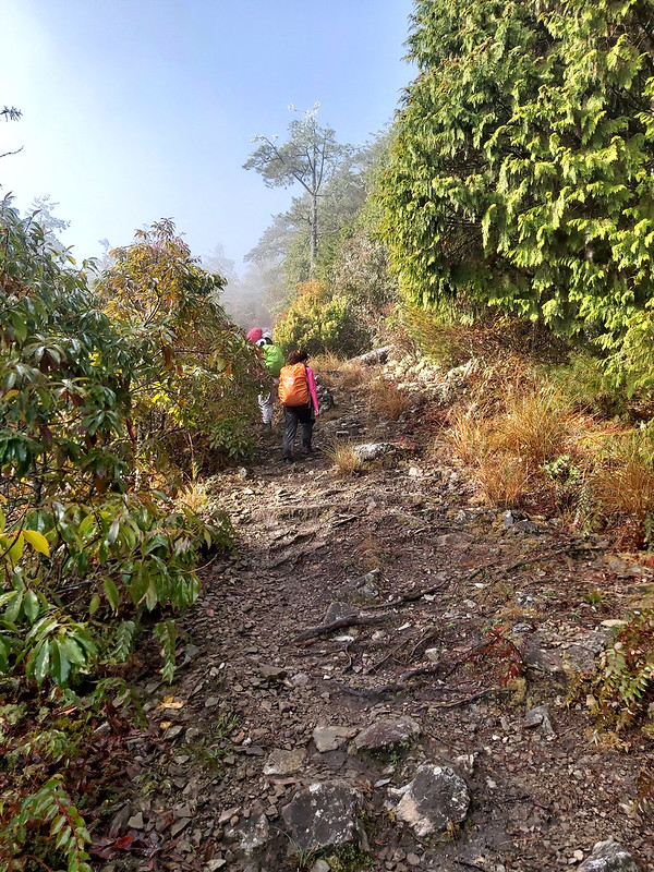
To Mt. Mawuzuye and Old Tree Forest
After Mt. Luoyewei, we were ready to get to our lunch place. We were told there were bamboo woods and it
should be easy. It turned out to be a different story. When our guides made their first trip to scout the
trail, there was no ice and the bamboo woods were intact, and they were able to pass through the woods
within ten minutes.
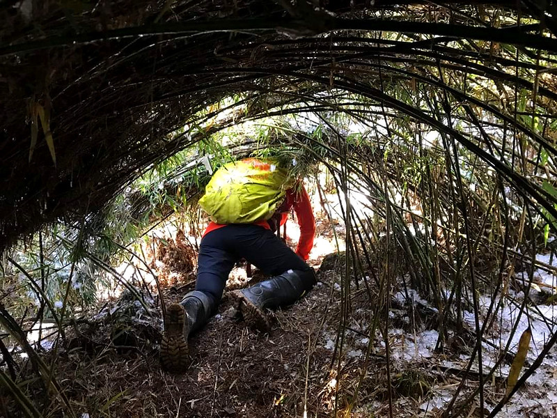
However, the unexpected cold weather and rain smashed the bamboo woods and the falling ice further bended
the woods, which made traversing more difficult. At several points, our backpacks were caught up with the
bamboos and it took some time to get ourselves free. Carrying a big heavy backpack and trying to bend down
and hike wasn't easy.

Many of us decided crawling might be the best tactic to tackle with the damaged bamboo woods. So, I can add
the experience of crawling on the ice with my knees on my hiking adventures. As you can imagine, it hurt and
cold to crawl on the ice.
This section took us much longer than expect to finish, and we finally arrived the place for lunch. We were
cold, exhausted and very hungry, and ready to devour anything edible. Our guides boiled hot water to prepare
ginger tea for us, which was a great delight to warm up our bodies.

Sitting in the woods and having my lunch, I could see the sunshine seeping through the trees leaves and the
mountains in the distance. I still felt a little bit cold, but very content. I was hoping I could get a
chance to hike Mt. Nanhu and Mt. Zhongyangjian someday, but, at that moment, being able to see the views
like this made me very elated and grateful.

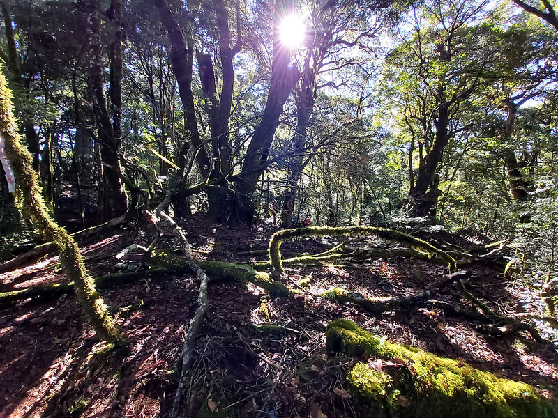
More Stunning Views Ahead: Holy Ridge Trail (Shengleng Trail) 聖稜線 from Mt. Mawuzuyejun 馬武佐野郡山
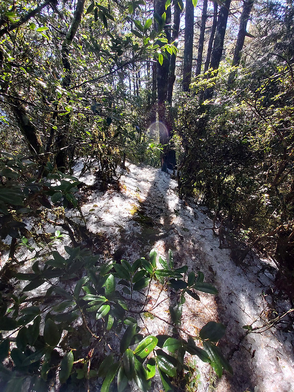
After lunch, the section of the trail was easier than the previous ones. It was still steep, but the terrain
was mostly covered by leaves and pine needles, and there were many majestic big trees with huge branches
reaching out along the trail.

There were several old trees here. The ferns and moss on the branches were like little fairies dancing among
twigs and beams of sunlight, and those made us easily to lose track of time. Our guides urged us to go
faster, because nobody wanted to hike in the dark if we stayed too long, and they promised us that there
would be a big surprise waiting for us.

More beautiful trees.

When we got out of the woods, the landscape opened up and Mt. Nanhu reappeared in front of us. Everyone was
excited and stopped to take photos, but our guides told us to keep moving.
Later, I realized they were right, because the landscape opened up even more. We not only saw Mt. Nanhu, but
also Holy Ridgeline Trail 聖稜線. From here, we could see Mt. Xue Main Peak, 3,886
meters (12,749 feet), the second highest mountain in Taiwan, was covered by snow. We were between two of the
most famous mountain ridgelines now.


I hiked to Mt. Xue East Peak, 3,201 meters (10,502 feet), before, but I didn't make it to Mt. Xue Main Peak.
I planned to hike there again but haven't got a chance yet. Seeing this and Holy Ridgeline Trail made me
feel I was getting close the Mt. Xue again.

Massive Descending with Silver Grass and Unexpected Sea of Clouds
Silver grass is a very strong plant that can survive in harsh environments, and you can see it almost
everywhere in Taiwan. After seeing two major mountain ranges, we made a turn and hiked through the silver
grass. Those views on this grassland made me stop here to take as many photos as I could. When you hike
here, please be aware of the big rocks hidden among the silver grass. It will hurt a lot or even break your
toes if you accidentally kick them.

Looking up, I saw Mt. Nanhu in front of us. The closer look made the snow even more visible to us. More
surprisingly, I got to see the sea of clouds here again. This time, the clouds were moving.

While continuing my hike, I heard shriek being let out from hikers in front of me. It turned out they saw a
rainbow out of somewhere. I still don't understand what they had seen, but whatever they saw must be
amazing, which add up an extra wonder we had on this hike.

After the silver grass land, the trail turned into a very steep one again, and we had to grab the ropes to
help us descend. If it were raining at that time, this part of trail would turn into a muddy nightmare,
slippery and difficult to hike.

Cross the River before Calling It A Day
Finally, we reached our last challenge before finishing the hike, because we were back to Yousheng River,
just like how we got started. Some of our hiking mate said their feet got wet even though they wore a pair
of rainboots. I wore rainboots, too, but I also wore a pair of rain pants which helped prevent water from
getting inside my boots.

When you cross the river, it can be very slippery to step on the rocks. Some of our hiking mates slipped
here. Since this is the last part of the hike, it doesn't matter if your feet get wet, because you are about
to finish this delightful hike.

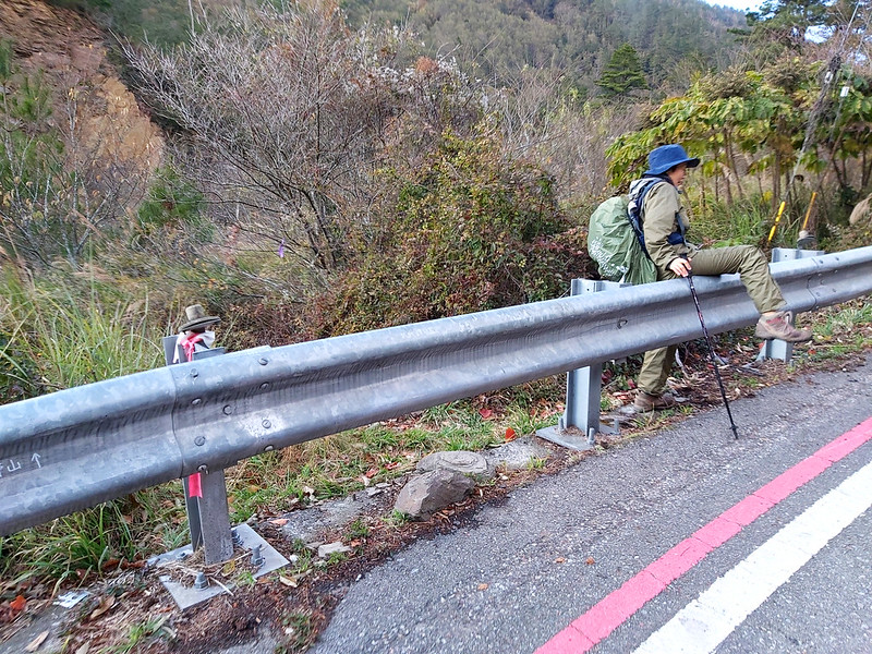
We had to climb over the fence to get back to our bus.
Thoughts about This Hike: How to Improve This Hike
This is a great trail with stunning mountain views, old forests and enough difficulty level if you enjoy
challenges. If I do this hike again, this will be how I do it.

The first thing is you need to sort out the transportation. If you drive there, you just need to walk extra
5 km to get back to your car after the hike.
Getting to the trailhead isn't difficult. I will take the first bus of either Bus 1751 or 1764 and get off
at Siyuan Police Station. Then, walk around 5 km to the other trailhead and camp there. Then do the hike
from the other trailhead. Then, take it easy and enjoy the camping on the first day.
Note: I found this beautiful image of Siyuan Yakou when it was very cold in late 2020. Not endorsing this company in any sort.
However, it will be trickier to arrange your transport after the hike, because the last bus for you to catch
at Siyuan Police Station is roughly at 14:40, which is impossible to finish the hike by then. It takes at
least 10 hours to finish the hike. So, you might need to camp near Siyuan Police Station for another night
and catch the first Bus 1751 back to Yilan Transfer Station at 9:40 the next morning.
In this case, you might need to prepare 3 days to hike this trail. This trail is great for all seasons,
especially to avoid the heat in summer. If you can spare 3 days to do this hike in summer, camping near the
trailhead might be a great idea. But please be cautious of the possible floods before you go.
What do you think about this trail? Would you like to take on ROMA hike? Please leave comments below and
subscribe to newsletters for more amazing trails in Taiwan.
Map and Itinerary
Group Hike or Solo Hike: Group hike with Taiwan Mountain LOHAS Association (LOHAS)
Date of Hike: December 8, 2019
Date of Hike: December 8, 2019
Click Menu in the map to download, print or share the map.
Click to change the speed to meet
your condition.
to change the speed to meet
your condition.
Note:
Due to GPS accuracy setting, there may be some difference between my GPS tracking and the exact distance. For some unknown reasons, my Sunnto GPS watch failed to record this trail properly. Here's the GPX I use here.
Click
to change the speed to meet
your condition.Note:
Due to GPS accuracy setting, there may be some difference between my GPS tracking and the exact distance. For some unknown reasons, my Sunnto GPS watch failed to record this trail properly. Here's the GPX I use here.
Based on my hike on December 8, 2019
06:30 Arrived at
trailhead near Siyuan Yakou
06:50 Crossed
Yousheng River and started the hike
08:30 The sun came
up
08:37 Saw the sea
of clouds above Siyuan Yakou
08:40 Took a break
and group photos
09:10 Resumed the
hike
10:44 Reached Mt.
Luoyewei and took a break and group photos
11:00 Resumed hike
and encountered the bended bamboo woods
11:30 Got out of
the bamboo woods
12:10 Lunch
break
12:45 Resumed
hike
13:54 Took a break
at ROMA Old Tree 羅馬神木
14:19 Reached Mt.
Wuzuye. No views, only the sign
14:38 Got out of
the old trees and reached the pass between Mt. Nanhu and Mt. Xue ranges
15:04 Reached Mt.
Mawuzuye and took a break
15:12 Resumed the
hike and started descending
15:22 Saw the sea
of clouds again on Mt. Nanhu side
16:05 Reached the
steep dirt slope
16:30 Reached
Yousheng River again
16:49 Reached the
highway (GPS: 24.365545, 121.336855) and got back to the bus
Total time: 10
hours 29 minutes, including breaks