A Tribute to Taroko: Shakadang Three Heroes - Mt. Qingshui, Mt. Qianliyan, and Mt. Liwu
Shakadang Three Heroes refers to three mountains, Mt. Qingshui (Qingshuidashan or Qingshui Big Mountain), Mt.
Qianliyan, and Mt. Liwu, near Shakadang Creek in Taroko National Park. This hike is challenging, but the views
of the East Coast of Taiwan are stunning from the rock scrambles.

However, the devastating magnitude 7.2 earthquake that hit Hualien, Taiwan, on April 3rd damaged the renowned
Taroko tremendously. I don't know how long it will take for Taroko to reopen again, and I'm not sure Shakadang
Three Heroes will be the same, either.
This post commemorates this breathtaking hike and Qingshuidashan, the mountain that I haven't had a chance to
visit. For any updates about Taroko National Park, click their website here.
Disclaimer:
All content is for inspiration only. Use Taiwan Hikes' suggestions at your own risk. We are not responsible for any losses, injuries, or damages.
All content is for inspiration only. Use Taiwan Hikes' suggestions at your own risk. We are not responsible for any losses, injuries, or damages.
Table of Contents:
Trail Information: Qingshuidashan 清水大山, Mt. Qianliyan 千里眼山, and Mt. Liwu 立霧山, aka Shakadang Three Heroes 砂卡礑三雄
Trail Name: Shakadang Three Heroes
Distance: 46.4 km (28.8 miles)
Route type: Out and back
Days/Hours Needed: 3 days
Total Ascent/Descent: 4,439m/4,421m
Permits: Not required
Difficulty Level:
Distance: 46.4 km (28.8 miles)
Route type: Out and back
Days/Hours Needed: 3 days
Total Ascent/Descent: 4,439m/4,421m
Permits: Not required
Difficulty Level:
Trail Name: Dali Datong Trail, Mt. Liwu, and Mt. Qianliyan
Distance: 24.6 km (15.3 miles)
Route type: Out and back
Days/Hours Needed: 2 days
Total Ascent/Descent: 2,518m/2,512m
Permits: Not required
Difficulty Level:
Distance: 24.6 km (15.3 miles)
Route type: Out and back
Days/Hours Needed: 2 days
Total Ascent/Descent: 2,518m/2,512m
Permits: Not required
Difficulty Level:
Peaks to Reach
- Mt. Qingshui, or Qingshuidashan, Mt. Qingshui, Mt. Cingshuei 清水大山, 2,408 meters (7,900 feet) above sea level.
- Mt. Liwu 立霧山, 1,274 meters (4,180 feet) above sea level. A Minor 100 Peaks in Taiwan.
- Mt. Qianliyan 千里眼山, 1,624 meters (5,328 feet) above sea level.
Accommodations and Map/GPX Data
There are several hostels in Dali and Datong Village. Most cost NT$1,500 per person per night, including
dinner, breakfast, a bunk bed or shared bed, and a hot shower. No hair dryer, toiletries, and charging outlet
are available.
Which one to stay in depends on where you hike. Those humble-looking hostels may not have fancy amenities, but
their beds are surprisingly comfy and warm. Moreover, they have the best views and surroundings you will never
see elsewhere.
In both villages, there is no electricity and no tap water. The hostels use generators and wood burners to
cook and boil shower water.

For Datong Dali Trail and Mt. Liwu: Dadao's House 達道的家 or Dali Lily Farm 大禮百合休閒農莊-大禮百合屋
Dadao's House has the best views among all the hostels here, and the beautiful Mt. Liwu Observation Deck is
close, too.

Dadao's House doesn't have a website. To make a reservation, call and text our arrival dates: +886 932019638. The cost is NT$1,500 per person per
night.

Dali Lily Farm 大禮百合休閒農莊-大禮百合屋 is right next to Dali Church. If you only want to
visit this church, staying here is the best option. I met the hostel host and had a brief conversation with
him. His hostel is NT$2,200 per person per night, and he serves indigenous delicacies.
I had never had a chance to stay here before the earthquake. Hopefully, I will in the future.
For Mt. Qianliyan and Qingshuidashan Hike: Rainbow House 彩虹屋
If you aim for either Mt. Qianliyan or Qingshuidashan or both hikes, staying at Datong Village will save you
time hiking in the dark.

I stayed at Rainbow House, and the hosts, Mr. and Mrs. Jian, were very friendly and nice. My
friend Tom stayed there and left his passport in the bunk bed. Mr. Jian even walked back to the trailhead to
return Tom's passport.

There is another hostel in Datong Village, Coconut House 椰果的家. Some hikers said the owner had to take care of
a sick family member, so they didn't receive hikers for a while.
GPX
Click Menu in the map to download, print, or share the map.
You can see more options after clicking the Play button.
Click to change the speed to meet your condition.
You can see more options after clicking the Play button.
Click
to change the speed to meet your condition.
Challenging Hikes with Rock Scrambles, A View of Crescent Bay, and Sunrise
Shakadang Three Heroes has been on my hiking list for years, but I only hiked to Dali and Datong Village. I
finally hiked to Mt. Qianliyan in November 2023, but Qingshuidashan is still waiting.
Each of these trails is proof of the unique beauty you can only find in Taiwan. I've done Dali, Datong Village +
Mt. Liwu, and Mt. Liwu + Mt. Qianliyan, each one leaving me with a sense of accomplishment and a thirst for
more.
If you're up for the challenge, these can be done in two days. But if you're ready to push your limits, put
Qingshuidashan in your itinerary, a three-day journey that will test your endurance and reward you with
breathtaking views.
My guide, Xiao Tsai, and my New Zealand friend, Tom Wilson, and A-nong 張嘉榮 kindly lent me their photos
at Qingshuidashan and Datong Dali Village. This hiker's post (only in Chinese): 清水大山|花蓮砂卡礑三雄 provides
details of the whole hike. The Shakadang Three Heroes' GPX is also from his post.
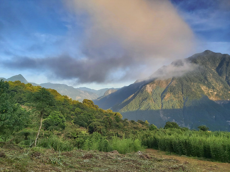
Breathtaking Hualien Coast
The night before the hike, we stayed in Hualien and stopped by the beach near Qixing Lake or Qixingtan. The
water and sky were blue and clear, and we could see Qingshuidashan from the beach.

Dekulun Trail, Dinosaur Ridge, Dali and Datong Village, and Mt. Liwu
If you do this hike, start as early as possible to avoid the rapidly changing weather around noon.
08:13 We started the hike from the north section of the Terrace Trail. The plank
footpath was next to the toilets at the Taroko Visitor Center.

08:23 There were two routes to do this hike. We took the more challenging route,
Dinosaur Ridge 恐龍背. This section was steep and rugged. Anong told me that one hiker fell to his death here.

When the earthquake hit on April 3rd, three hikers were struck to death by falling boulders
here.
08:59 We reached the first pulley station. The views were great here,
overlooking the Taroko Visitor Center. We took a long break here.


Those pulley stations were the lifeline for Dali and Datong Village residents. Transporting 300 kg of goods is
NT$6,000 (USD185, 175 Euros). The full gas cylinder weighs 40 kg, and the empty one weighs 20 kg, plus other
daily goods that the residents need to use.
09:28 We reached the end of Dekalun Trail, which is connected to the Shakadang
Forest Road 砂卡礑林道 and Dali Village.

10:27 We arrived at a small weather station, where some farm carts were parked.

10:43 We reached the entrance to Dali Village.

10:53 We passed an old police station and saw signages about Xoxos 赫赫斯.

The Dali Church with the Breathtaking Views
11:03 We passed some tables and chairs and took the small gap in the bush. Soon,
we reached my favorite church in Taiwan, Dali Church.
We took a 50-minute lunch break to enjoy this view. This was my second time visiting this place. We were lucky
that the weather was still good. The clouds in the sky were so mesmerizing.
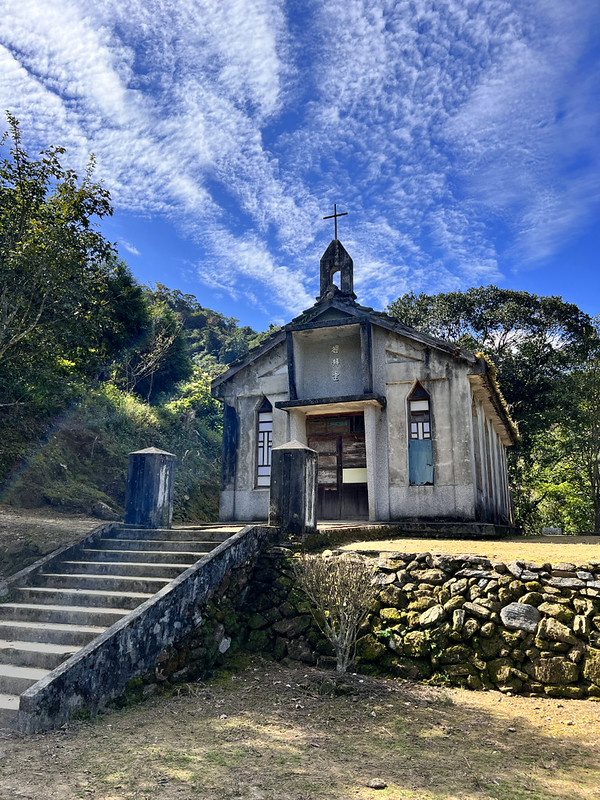
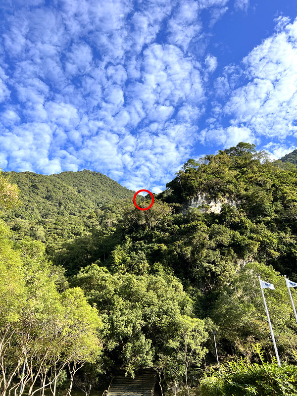
Qingshuidashan and Mt. Qianliyan were clear to be seen.

12:05 We reached the second pully station. The local villagers transported their
goods using this method, and the cost was based on weight. There was no electricity or tap water here.


13:06 We arrived at the junction to Mt. Liwu. I took this route in July 2020.
When I did this hike again, I saw a new route if you start from Dadao's House. If this trail opens again in the
future, take that one.

13:54 We arrived at Mt. Liwu, with no views to enjoy.

We went to the Liwu Mountain Observation Deck from Mt. Liwu, and this section was slippery and treacherous. I
don't recommend taking this one.

14:32 We arrived at Liwu Mountain Observation Deck. Unfortunately, the clouds
had taken over the blue sky. If you come here and can get up early, catching the first ray of sunshine is
definitely worth the effort.


14:55 Dadao's House is nearby. This was my favorite hostel in this area because
of the fantastic views.

16:14 We reached our destination for the day, Rainbow's House. If you do
Qingshuidashan and Mt. Qianliyan, staying here is a must.

Hike to the Rock Scrambles with the Fantastic Views: Mt. Qianliyan
It's better to start the hike around 4 a.m. or even earlier to see the sunrise. Despite the weather's
uncertainty, with the previous night's rain, I decided to take a chance.

Make sure to check where the entrance is before your hike. I couldn't see it in the dark but headed into the
woods anyway.
It was pitch black if we didn't turn on our headlamps. Before hiking, I feared the dark, even with people around
me. I still don't know how I overcame the fear. After the rain, the trail became much more slippery.

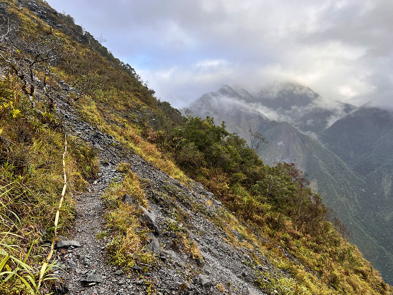
After hiking in the woods for what seemed like forever, we finally reached the ridge. However, this didn't mean
the hike became more accessible. The trail on the ridge was like the section between Mt. Liwu and the
observation deck.

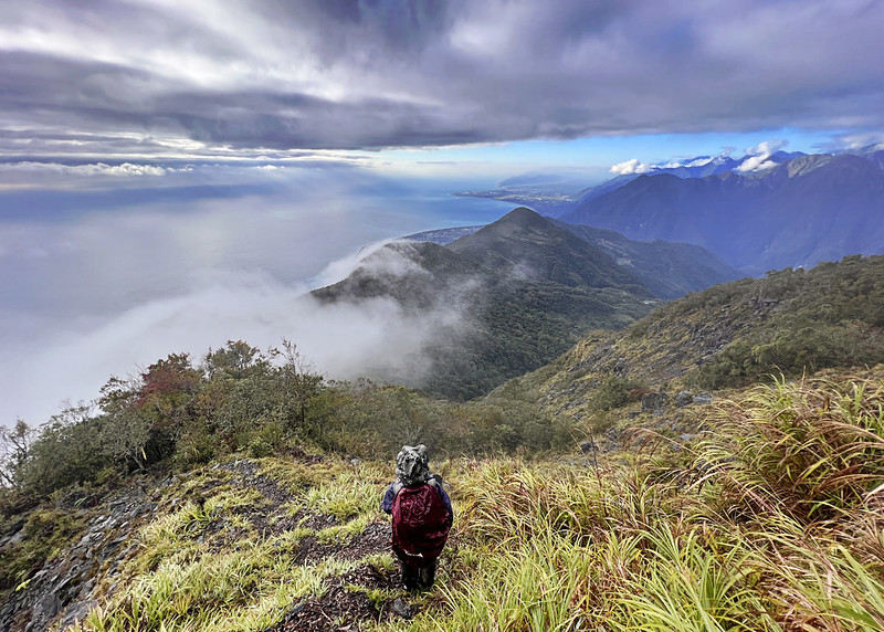
06:44 The sky became brighter but still gray. I prayed that we could see some
views. My prayer was answered when we finally exited the woods and reached a rock scramble.
We saw Dadao's House and other buildings in the lower mountains. On our right were Mt. Liwu Main Peak 立霧主山,
3,069 meters (not Mt. Liwu), and the famous Mt. Qilai Main Peak 奇萊北峰, 3,607 meters. There are also other
beautiful yet rugged mountains here.

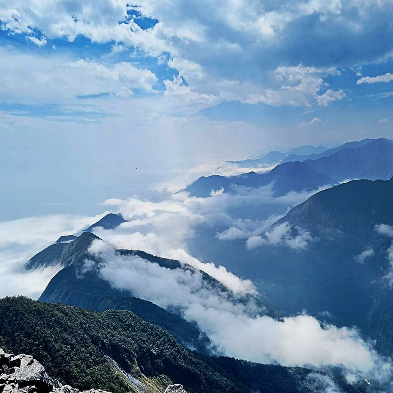
We reached another rock scramble, which was more strenuous than the previous ones. However, this was the perfect
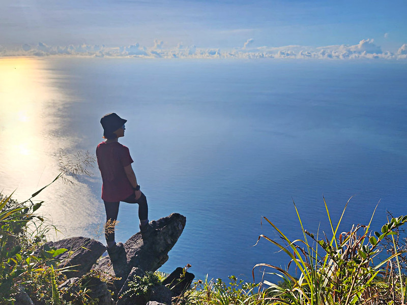
spot to see the sunrise! We could catch the clouds, the blue ocean, and the coast views.
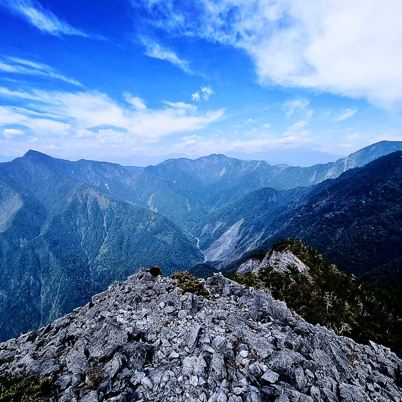
07:27 We entered the woods again and reached Mt. Qianliyan, 1,624 meters. There
were no views here. I told myself that if I did this hike again, I would stay at the rock scramble to see the
sunrise.

While returning to our hostel, Mother Nature rewarded our dedication with the fantastic views. The clouds flew
over the mountains, and then the blue sky decided to call it a day.

If you thought climbing up this rock scramble was demanding, descending was even more tricky. Getting a footing
on the loose rocks was hard enough, and we even took several wrong turns.

10:17 I returned to the grass slope before Rainbow's House. I sat there and shot
a timelapse video while waiting for my friend. We all hope for a blue sky on the trails, but the clouds and rain
often surprise us the most.

12:00 We finally left our hostel and returned to the Tarok Visitor Center. We
planned to take the Shakadang Trail back, but other hikers we met on the trail told us it was closed that day.
In hindsight, it was a shame.

We decided not to take the Shakadang Trail and hiked on Tong Li Trail, aka Xoxos Trail. This section was more
rugged than Shakadang Forest Road and was definitely not for new hikers.

13:19 We passed an old suspension bridge. I wonder if it survived the big
earthquake on April 3.

13:21 We reached the second junction of the Shakadang Trail and took a short
break.

14:19 We were back at the houses near Dali Church. We were already tired, so we
continued without going to the church again.

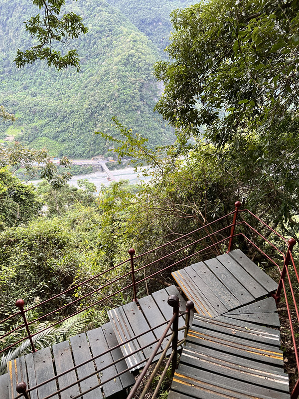
15:30 We were back at the start of Dinosaur's Ridge, but we took the Dekalun
Trail instead. This was my first time seeing what Dekalun Trail looked like. The endless and steep steps made my
knees buckle.

16:12 Finally, we returned to the visitor center and called it a day. Please see
my post about the hike from
Datong Village to Shakadang Trail.
A Short Description of Qingshuidashan or Mt. Qingshui Hike 清水大山 with the View of Crescent Bay
I haven't had a chance to hike Qingshuidashan, and I'm not sure when I can after the earthquakes. I'd like to
thank my friends Tom Wilson and Xiao Tsai for lending me their photos. If you think Mt. Qianliyan is hard,
Qingshuidashan is even harder. The following is a brief description of this remarkable hike.

The round trip from Rainbow House to Qingshuidashan is around 12-14 hours, depending on your pace. Like hiking
Mt. Qianliyan, it's better to hike in the very early morning, reaching the summit before 11 a.m. or even
earlier. The weather changes fast, and you might only see the clouds if you hike too late.
There are several campgrounds and water sources on the way to Qingshuidashan. So, you can carry a filter to
reduce weight.

Yet, the hard work pays off with those stunning views, the famous Crescent Bay 月牙灣.

And the spectacular views of Mt. Nanhu 南湖大山, 3,742 meters, which also has dashan in her name.

About Mt. Qianliyan, Mt. Liwu, Qingshuidashan, and Xoxos
Dekalun Trail 得卡倫步道
The Dekalun Trail, completed in 2003, is named after the indigenous people of the Taroko's Dekalun tribe that
once inhabited the Taroko Plateau.
The Dali and Datong Trail or Xoxos Trail 赫赫斯
The Dali and Datong Trail or Xoxos Trail, once a vital connection for residents, is also an essential path to
Qingshuidashan. Nestled at about 1,000 meters above sea level, Dali and Datong Village can be accessed via three
paths: the Dekalun Trail on the Taroko Terrance (plateau), the Shakadang Trail at Sanjianwu, and a small
staircase near the Liwu Power Plant.

Approximately two to three centuries ago, the indigenous Taroko people migrated from the Nantou Wushe area 南投霧社,
crossing the Mt. Qilai and Hehuanshan to settle in the Liwu and Mugua River basins. During the Japanese rule,
most were forced to relocate.
Only the villages of Xoxos (Dali's old name), Shakadang (Datong's old name), and Sila'an were spared due to
their agricultural areas, located on the plateau between the Shakadang River valley and the Qingshuidashan
range. The views from the plateau include Qingshuidashan, Mt. Qianliyan, Mt. Baifa 白髮山, Mt. Sanjiaozhui 三角椎山,
Tashan 塔山, and more.
Mt. Liwu 立霧山
Mt. Liwu, also known as Mt. Chongde 崇德山, is one of Taiwan's Minor 100 Peaks. It is located in the watershed
between the Liwu River, the Shakadang River, and several streams flowing into the Pacific Ocean.

Mt. Qianliyan 千里眼山
Mt. Qianliyan, one of the Shakadang Three Heroes, is also known as Mt. Shikeng 石硿山. Though remote, its untouched
ecosystem and pristine landscapes are preserved. While the summit offers no views, the ridgeline provides
spectacular scenery over the Pacific Ocean.
Mt. Qingshui, Qingshuidashan 清水大山
Taiwan's most spectacular landscapes undoubtedly include the Qingshui Cliff and the Taroko Gorge, shaped by the
mighty Mt. Qingshui — a classic among Taiwan's mountains.

Mt. Qingshui, also known as Qingshuidashan, embodies magnificence. It is rightly named 'dashan 大山,' meaning 'big
mountain.' Composed of solid marble, it rises abruptly from sea level to over 2,000 meters. Its almost
perpendicular cliffs drop dramatically to the Pacific Ocean, creating the famous Qingshui Cliff. The
geographical features of Qingshuidashan are unique. It is close to the coast and enveloped in mists almost
around noon due to its abundant moisture.
Mountains bearing the name 'dashan' in Taiwan are unfailingly challenging hikes.
