100 Peaks: Qilai Nanhua Trail Complete Hiking Guide (Trail Closed)
Qilai Nanhua, a short name for Mt. Qilai South Peak and Mt. Nanhua, is one of Taiwan's most accessible and
most popular 100 Peaks trails for. The stunning sunrise from the Central Mountain Range is the most iconic
trademark of this hike. The hike to Mt. Qilai South Peak and Mt. Nanhua is a hike worth doing every year!

Important: Qilai South Peak is closed, and the trailhead I did is also closed for good. Please
check the Hike Smart Taiwan Service website for update.
Disclaimer:
All content is for inspiration only. Use Taiwan Hikes' suggestions at your own risk. We are not responsible for any losses, injuries, or damages.
All content is for inspiration only. Use Taiwan Hikes' suggestions at your own risk. We are not responsible for any losses, injuries, or damages.
Table of Contents:
- Trail Information
- Personal Enjoyment
- Map/GPX Data
- How to Get Tunyuan Trailhead
- Day 1: Started the Hike at Noon and Saw the Stunning Sunset
- Day 2: Got Disappointed At First But Rewarded with Great Views
- About Qilai Nanhua Hike and Other Trails Nearby
- High Altitude and Misassumption
- How to Apply for Permits and Tianchi Lodge: Be Prepared to Apply for Several Times
- Meals, Sleeping Bags, Tents, and Pads
- Acknowledgement and Related Posts
Trail Information
Trail Name: Qilai Nanhua Hike. The full name is 100 Peaks Mt. Qilai South Peak
and Mt. Nanhua
Distance: 37 km (23 miles). Day 1: 13.1 km. Day 2: 23.9 km
Route type: Out and back
Days/Hours Needed: At least 2 days. Some trail runers do it in one day.
Total Ascent/Descent: 2,300m/2,300m
Best Time to Go: All year-round, unless the trail was closed due to landslides or typhones.
Permits: Yes. Please click here for details.
Difficulty Level:
Peaks to Reach:
- Tunyuan Trailhead (or entrance): 屯原登山口, 2,000 meters (6,562 feet)
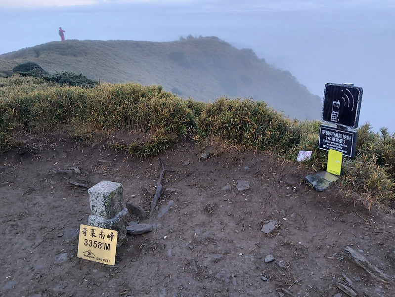
- Mt. Qilai South Peak: 奇萊南峰, 3,358 meters (11,017 feet). There's a Class 2 Triangulation Stone on the peak
- Mt. Nanhua, aka Mt. Nenggao North Peak: 南華山 (能高北峰), 3,184 meters (10,446 feet). There's a Class 3 Triangulation Stone on the peak.
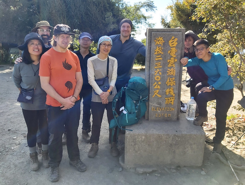
- Yuanhai Line Station: 雲海保線所, 2,360 meters (7,743 feet), located at 4.9 km on the trail. Before you reach Yuanhai Line Station, you will see an Earth God temple, Fuyuan Temple 福雲宮 first.
- Tianchi Lodge: 天池山莊 or Tianchi Hostel or Tianchi Mountain Villa, as you might see on the sign on the trail, 2,860 meters (9,383 feet). Tianchi Lodge is also considered a 5-star lodge on 100 Peaks trails.
- Tianchi or Tian Pond: 天池, 3,100 meters (10,171 feet), a pond located at the junction to Mt. Qilai South Peak and Mt. Nanhua.
- Kuang Pei Pa Piao Monument: 光被八表, 2,800 meters (9,186 feet). It's not a peak, but most hikers will go there to witness one of the most remarkable histories that helped Taiwan's economy grow.

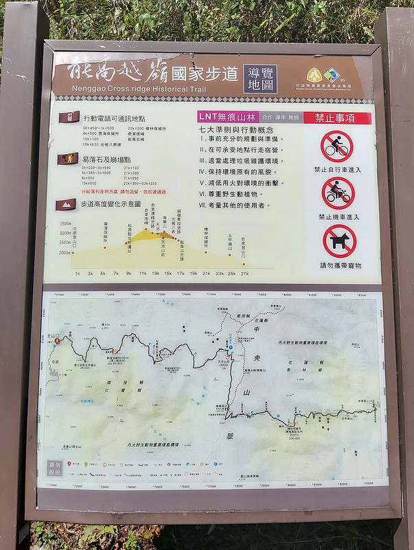
Risk of Falling Rocks When Passing Slopes:
Tianchi Lodge has issued warning of the risk of falling rocks at several sections: 0.6K, 6K, 7K, and 10K. The risk of falling rock hazard can happen anytime, whether it's sunny or raining. Please make sure it's safe before you pass and pass those areas as fast as you can.
Tianchi Lodge has issued warning of the risk of falling rocks at several sections: 0.6K, 6K, 7K, and 10K. The risk of falling rock hazard can happen anytime, whether it's sunny or raining. Please make sure it's safe before you pass and pass those areas as fast as you can.
Personal Enjoyment
Things I Enjoy:
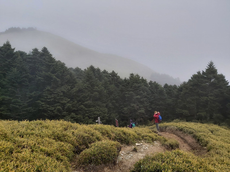
- The trail is easy to navigate. There are several junctions, but you can easily find the way you need to go. We hiked in the dark for a while, and we felt confident in the night.
- The layers of mountains are stunning. You will see them all the way from the trailhead, Tianchi Lodge, and the peaks. I could always see something new during my two trips to Qilai Nanhua, and I was totally in awe.
- You will find many mobile signal spots on the trail. Now, you can enjoy WiFi at Tianchi Lodge, too. When I was there, WiFi was not available at Tianchi Lodge.
- You can bring a light backpack without a sleeping bag, a tent, and a sleeping pad. You even don't have to bring a stove because you can rent meals and the gear.
Things I Don't Enjoy:
- This hike is relatively easy compared to the other 100 peaks. Moreover, Tianchi Lodge is new and spacious compared to other cabins on 100 Peaks.
- Those things sound great. What's wrong with me for not enjoying those? Unfortunately, just because of those great features, Qilai Nanhua has attracted tons of hikers (or non-hikers), making getting to the cabin or campsite so tricky. Covid-19 makes domestic travel even more packed.
- If you plan to hike, please avoid the weekends or holidays to increase your chance. It took us twice to get the permits.
Map/GPX Data
Date of Hike: Group hike on December 2 and 3, 2020
Route map for 100 Peaks In Taiwan: Qilai Nanhua by Anusha Lee on plotaroute.com
Click Menu in the map to download, print or share the map.
You can see more options after clicking Play button.
Click to change the speed to meet your condition.
You can see more options after clicking Play button.
Click
to change the speed to meet your condition.
How to Get Tunyuan Trailhead
Hire a car if you have enough people to share the cost. The van we hired was NT$12,000 (USD409, 340 Euros) in
late December 2020, and can seat 8 people plus a driver.
No worries if you don't have enough people to hire a car. You can still take public transport to the trailhead
from Taipei, Taichung, or Kaohsiung.
From Taipei to Puli 埔里
Take Kingbus 1832A (must take the one with A) from Taipei Bus Station to Puli Station. The one-way ticket is
NT$405 (October 21, 2021), and the estimated time is around 3 hours if the traffic is good. There is a KFC
Restaurant close to Puli Station.
You can take Taiwan High Speed Rail from Taipei to Taichung, and then take the shuttle bus
from Taichung Station to Puli. But I think take Kingbus 1832A directly from Taipei is the easiest. You can check
From Taichung to Puli below for details.
From Kaohsiung to Taichung
Take Taiwan
High Speed Rail from Zuoying to Taichung. You can check out their website to see the timetable and train
tickets.
From Taichung to Puli
Take Nantou Bus 6670 at Platform 3 on the first floor, High Speed Rail Taichung
Station, and get off at Puli Station. The bus fare is NT$110 (October 21, 2021), and the estimated time
is 50 minutes.
From Puli to Lushan 廬山
Take Nantou Bus 6660 at Puli Station, and get off at Lushan 廬山 (NOT the hot spring
one, because some buses don't stop at Lushan). The bus fare is NT$135 (October 21, 2021), and the estimated time
is 1.5 hours.
I suggest you to purchase EasyCard or iPass 一卡通 and deposit enough money to pay the bus fares, which
will be easier without carrying too many changes and you can also have some discounts. Multiday Passes cannot be
used here.

Day 1: Started the Hike at Noon and Saw the Stunning Sunset
Distance: 13.1 km (8 miles)
Brief itinerary: Tunyuan Trailhead (height 2,000m) ➔ Yuanhai Line Office (height 2,360m) ➔ Tianchi Lodge (height 2,860m)
GPS coordinates Tunyuan Trailhead: 24.050745, 121.215445
Brief itinerary: Tunyuan Trailhead (height 2,000m) ➔ Yuanhai Line Office (height 2,360m) ➔ Tianchi Lodge (height 2,860m)
GPS coordinates Tunyuan Trailhead: 24.050745, 121.215445
06:10 Headed to Nantou from Taipei Train Station. It had been raining a lot in
northern Taiwan before our hike to Qilai Nanhua. It was no exception when we met at Taipei Train Station on
December 2nd, 2020. Lucky for us, the weather turned better and better when we were heading south.
09:55 Visited Geographical Center Stele of Taiwan.
When we picked up 2 of our hiking mates who lived in Kaohsiung, Glenn and Walt, our driver proposed to take us
to see Geographical Center Stele of Taiwan 臺灣地理中心碑 (23.974082, 120.979670). I never
knew we had this, and we thought, why not.

11:40 Arrived at Tunyuan Trailhead.
We started hiking after 10 minutes.
It was behind my schedule for about 40 minutes, but I thought it should be ok. I planned to finish this hike in 5 hours. For hikers with a faster pace, it takes around 4.5 hours.
We started hiking after 10 minutes.
It was behind my schedule for about 40 minutes, but I thought it should be ok. I planned to finish this hike in 5 hours. For hikers with a faster pace, it takes around 4.5 hours.
12:07 We passed the sign of the phone signal spot.
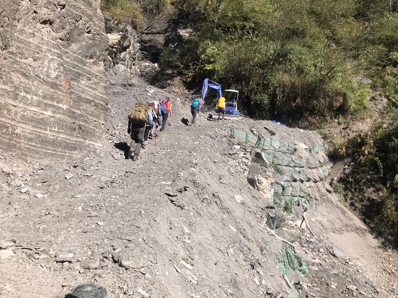
It was gradually uphill from the trailhead to Tianchi Lodge. The trail condition was mostly good. When we were there, several constructions were going on near the trailhead, where a tragic accident happened after we left.
It was gradually uphill from the trailhead to Tianchi Lodge. The trail condition was mostly good. When we were there, several constructions were going on near the trailhead, where a tragic accident happened after we left.

12:39 Arrived at the sign telling the history of the powerline and took a long
break.
We reached a section with several massive powerlines flying high above us. There was a sign telling the history of the electricity development in Taiwan and the role of Nenggao Cross-Ridge Trail played to boost the economy for future generations.
We reached a section with several massive powerlines flying high above us. There was a sign telling the history of the electricity development in Taiwan and the role of Nenggao Cross-Ridge Trail played to boost the economy for future generations.

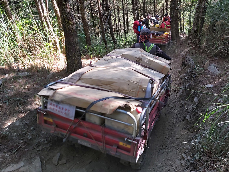
We also took a long break while letting several small agricultural vehicles and motorbikes pass. Those vehicles
were taking supplies and food that hikers needed at Tianchi Lodge. Other vehicles or bicycles are not allowed on
this trail unless you have permission.
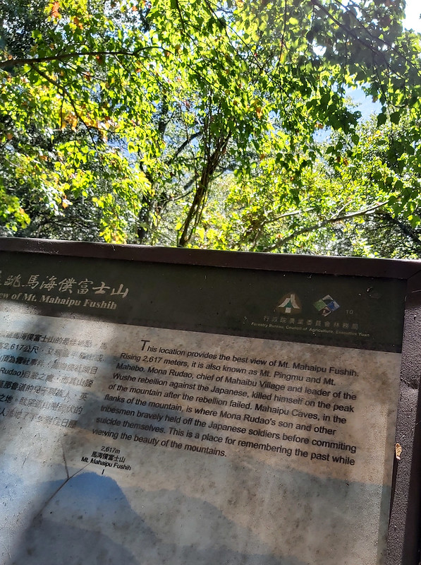
13:25 Passed the sign of Mt. Mahaipu Fushih, but trees blocked the view.
We passed a sign saying we could see Mt. Mahaipu Fushih 馬海濮富士山 (2,617 meters /8,586 feet) from there, but we could only see trees. So, we went further and finally saw this mountain.
We passed a sign saying we could see Mt. Mahaipu Fushih 馬海濮富士山 (2,617 meters /8,586 feet) from there, but we could only see trees. So, we went further and finally saw this mountain.

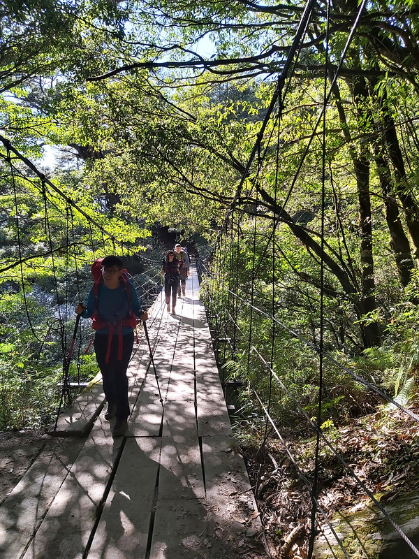
13:35 Passed a suspension bridge.
13:38 Passed Fuyuan Temple and then arrived at Yuanhai Line Station at 5 km.
When you see this temple, you will know Yuanhai Line Station 雲海保線所 is around the corner. We reached Yuanhai Line Station within 3 minutes.
When you see this temple, you will know Yuanhai Line Station 雲海保線所 is around the corner. We reached Yuanhai Line Station within 3 minutes.

You will find good phone reception at Yuanhai Line Station. As usual, I made our group take group photos here.
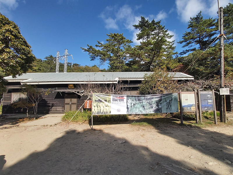
When I first visited Yuanhai Line Station, there was no toilet. We had to relieve ourselves in the back of the
office. Unfortunately, you would see awful things left behind by lousy hikers. I'll spare the details here. It's
good that there are toilets now, but sometimes the toilets don't have enough water. So, be prepared for
something not so pleasant.
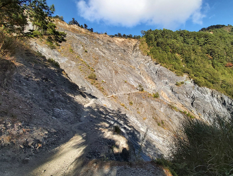
14:41 Passed the unstable rock slope at 5.9 km. This slope was easy to pass, but
the problem is you don't know when the falling rocks decide to land and land on your head. So, please pass this
area as soon as possible. It was close to 3 pm when we went through this area.
15:51 Passed Charcoal Klin Remains 木炭窯遺址. I felt that we might have to hike in
the dark before reaching Tianchi Lodge.

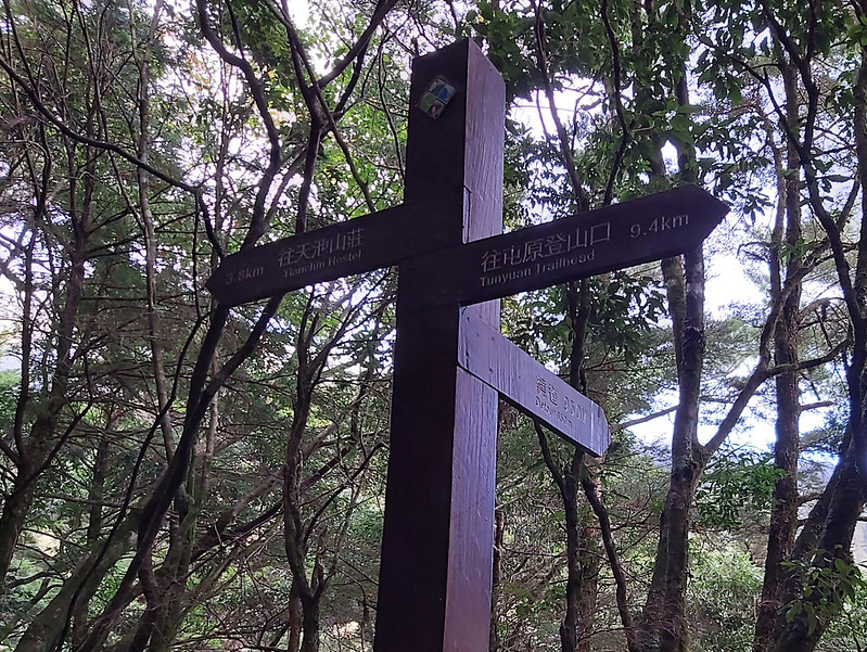
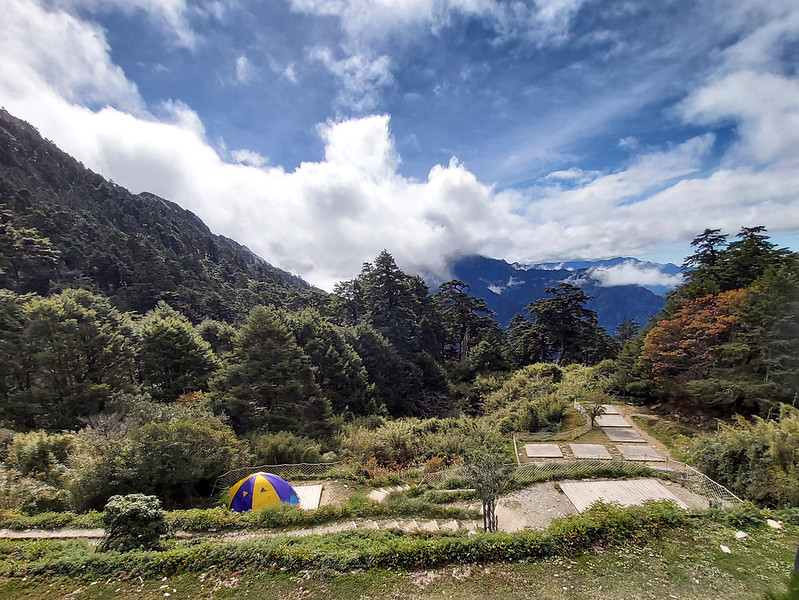
16:18 Saw the sign to Tianchi Hostel (Lodge) 3.8 km.
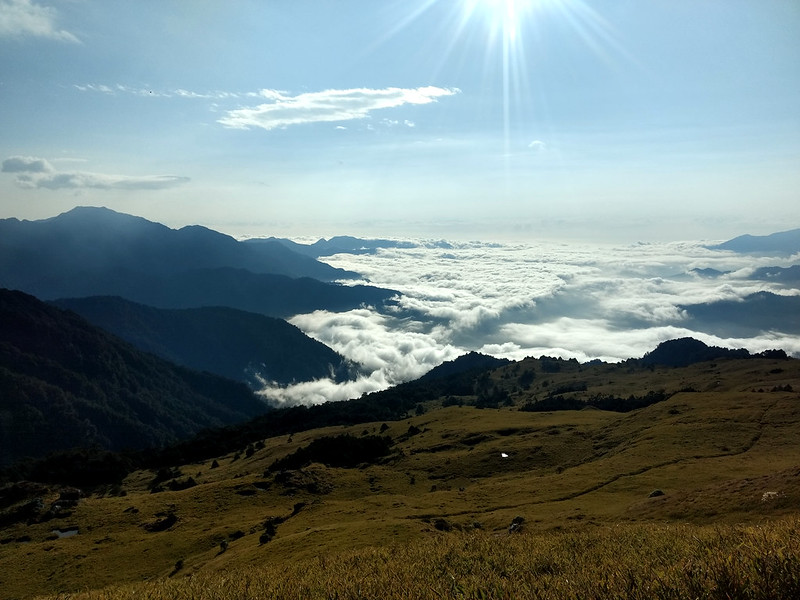
Although our chance to hike in the dark was getting bigger, more clouds were spilling over the ridges in the
distance, and it looked amazing. If it weren't that we needed to go faster, I would love to stay there longer to
see the sunset.
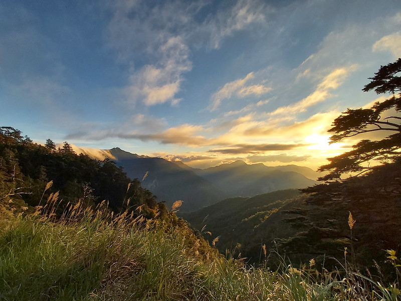
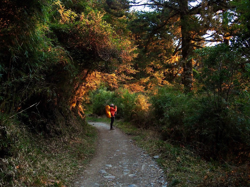
17:10 Sun started setting. We saw stunning sunset in the woods.
Ami from Taiwan Trails and Tales took this fantastic photo of me. She is not
only a good writer but also a great photographer.
I knew it was inevitable that we had to hike in the dark. The trail was straightforward to hike, and we all had
headlamps. So, hiking here at night was not a big deal. It was just we couldn't see Tianchi Lodge and the
powerline near Kuang Pei Pa Piao Monument from the trail.
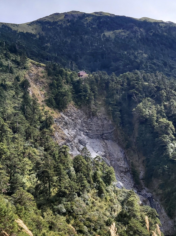
18:00 Arrived at Tianchi Lodge.
When we reached Tianchi Lodge, other hikers were already having dinner. I hurried inside to check in with the
lodge master and get our hiking mates to have dinner. Luckily, we still had some food left.
If the food wasn't enough for us, we still had a tiny chocolate cake. Two of our hiking mates were born in
December, although the cake didn't look very well after sitting in my backpack after the 13km hike.

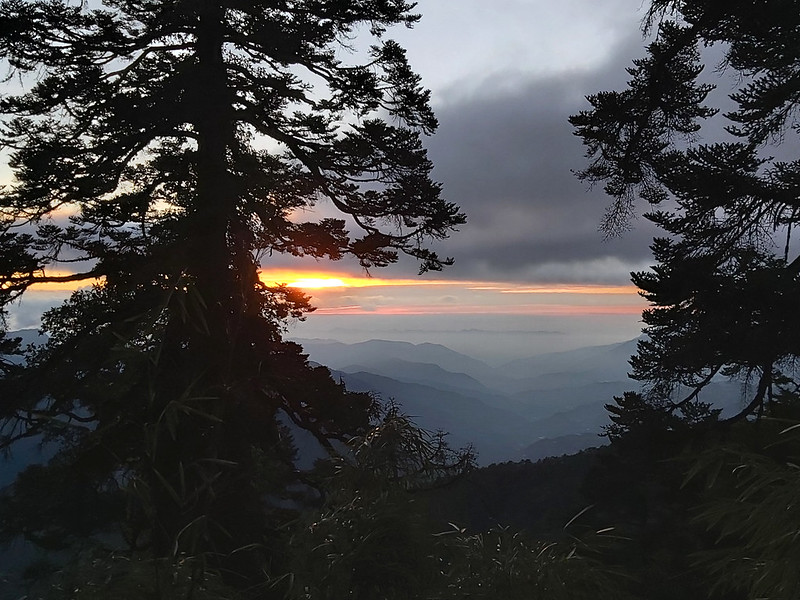
After we settled down in our room, we went out to look at the sky. I didn't have a good camera to capture the
amazing sky, so I don't have any photos to share here. But, once you see it, you will not forget.
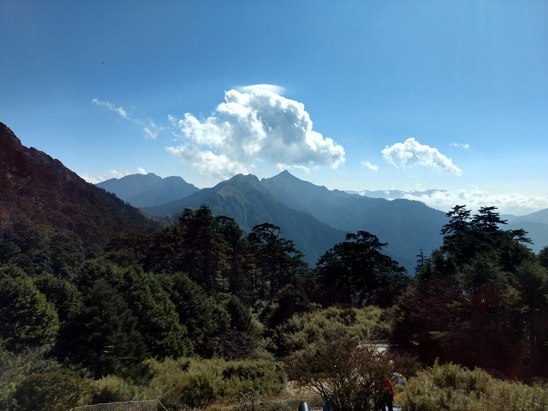
If you arrive at Tianchi Lodge early, you will see Mt. Nenggao Main Peak in the distance. It's very easy to
recognize the peak from a distance because of its almost perfect triangle shape. I took this one during my first
visit to Tianchi Lodge in 2019.

Day 2: Got Disappointed at First but Rewarded with A Great Delight
Distance: 23.9 km (14.8 miles)
Brief itinerary: Tianchi Lodge (height 2,860m) ➔ Tian Pond/junction (height 3,100m) ➔ Mt. Qilai South Peak (height 3,358m) ➔ Tianchi junction ➔ Mt. Nanhua (height 3,184m) ➔ Tian Pond/junction ➔ Tianchi Lodge ➔ Yuanhai Line Office (height 2,360m) ➔ Tunyuan Trailhead (height 2,000m)
Brief itinerary: Tianchi Lodge (height 2,860m) ➔ Tian Pond/junction (height 3,100m) ➔ Mt. Qilai South Peak (height 3,358m) ➔ Tianchi junction ➔ Mt. Nanhua (height 3,184m) ➔ Tian Pond/junction ➔ Tianchi Lodge ➔ Yuanhai Line Office (height 2,360m) ➔ Tunyuan Trailhead (height 2,000m)
02:00 We got up early to see the sunrise.
Before our departure, I had been telling everyone how beautiful it was to see the sunrise from Mt. Qilai South Peak, and we all had high hopes that we would see it.
Before our departure, I had been telling everyone how beautiful it was to see the sunrise from Mt. Qilai South Peak, and we all had high hopes that we would see it.
03:00 Had breakfast.
04:00 Started hiking.
The junction to Mt. Qilai South Peak and Mt. Nanhua was only 100 meters from Tianchi Lodge. The trail is easy to follow, with steps all the way up.
The junction to Mt. Qilai South Peak and Mt. Nanhua was only 100 meters from Tianchi Lodge. The trail is easy to follow, with steps all the way up.
While we were taking our time waiting for our hiking mates to catch up, we suddenly saw a tiny head with two
reflective eyes sticking out of the gutter. It turned out that it was a golden weasel.
I think this fellow was very curious about us, so it stuck out its head at least three times from the gutter,
which reminded me of the game Whack A Mole. It was a pity that it was already gone when I tried to take a photo
of it.
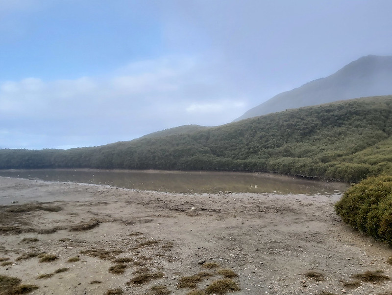
04:55 Reached Tianchi, the pond, or Tian Pond. Some hikers went to Mt. Nanhua
first, but we decided to see Mt. Qilai South Peak because that was what I did last time, where I saw the
fantastic sunrise from Hualien.
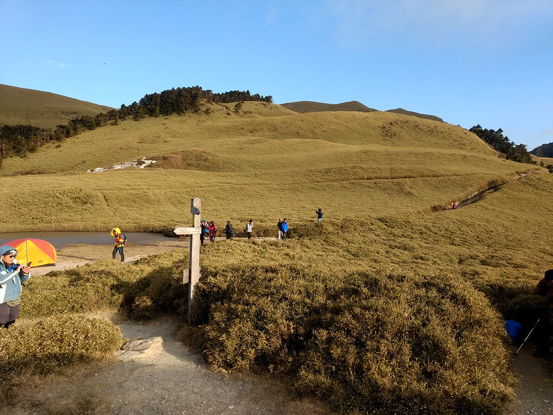

We descended to a valley near Tian Pond and then went up. The trail terrain became less obvious, especially in
the dark. If you hike here and see other hikers near you, try to stay close to them, or you must have a GPX
track with you.
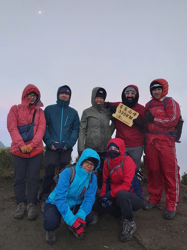
06:20 Arrived at Mt. Qilai South Peak. Before we arrived there, we could still
see stars in the sky. However, it became so cloudy that we didn't see any amazing sunrise at all by the time we
got there.
We let the big group take photos first. Then, after they left, we took our time taking pictures. We were
disappointed by not seeing the amazing sunrise, but this is normal when you go hiking.
We still had to visit Mt. Nanhua. We got back to the trail we took earlier, and the sky became brighter and
brighter but still cloudy.
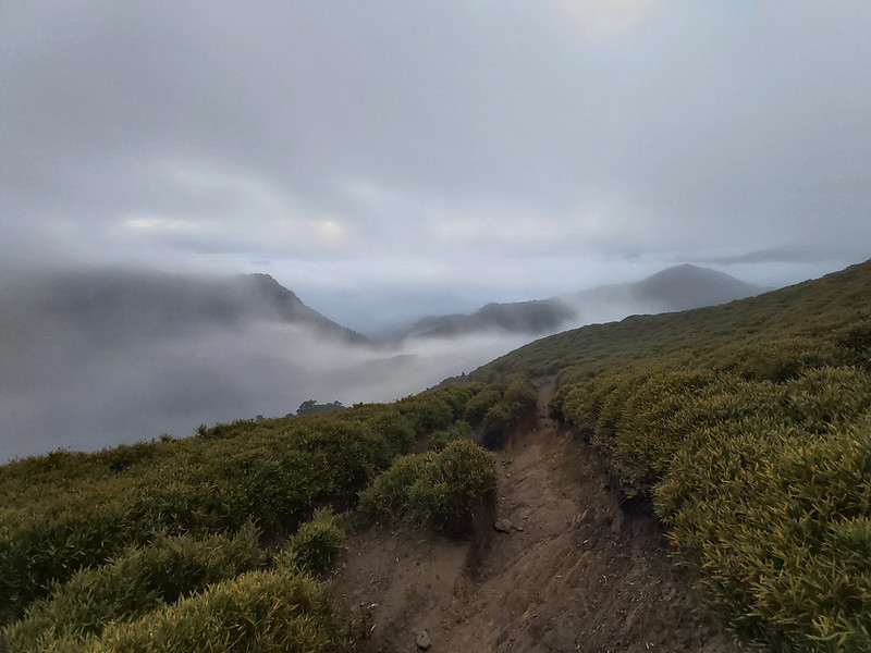
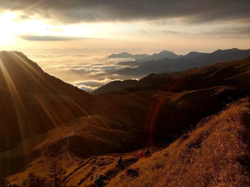
06:45 Suddenly, we could see some patches of blue in the sky. We were stunned
when we turned to see Mt. Nanhua and the ridgeline. At least, I was.

The clouds from the Hualien side (eastern Taiwan) that disappointed us shifted into a cloud waterfall, flowing
over the ridge and spreading in the air in western Taiwan.
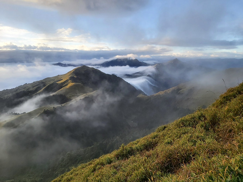
The ridgeline was part of the Central Mountain Range 中央山脈.

The Central Mountain Range not only divides Taiwan into the east and the west, the borderline to separate
Hualien and Nantou, but also plays a huge role in affecting the weather on both sides.
181 out of 268 mountains above 3,000 meters are on this mountain range. Furthermore, 69 of those 181 mountains
are listed in 100 Peaks.
When we were there, Hualien was still hidden by the thick clouds. But when we glanced to the west, it was sunny
with some clouds in the blue sky.
If the weather were great, we would be able to see the famous grassland bathed in the golden hue during sunrise.

As a great photographer, Ami still captured the golden hue in unfavorable weather conditions like this. I
was so thrilled and humbled to be in the photo.

07:45 We returned to Tian Pond and took a break. Some of our hiking mates
decided to return to Tianchi Lodge. The rest of us continued to hike Mt. Nanhua.
We felt a little bit pressured because we had to get back to Tianchi Lodge before 10 am. So, we would have time
to eat the after-hike meal, pack our belongings and check out at the required 11 am.
08:15 Headed to Mt. Nanhua. The trail condition wasn't as good as Mt. Qilai
South Peak. After we went through a small forest, the trail became muddy and slippery. It was pretty dry when I
first hiked here in 2019.
Another thing worth mentioning is the vegetation on Mt. Nanhua. It is mostly grassland, with no bamboo woods or
tall trees. So, you can almost see very far if the weather is good.

08:41 Arrived at Mt. Nanhua peak and took a break. When we reached Mt. Nanhua
peak, the clouds were still floating over the ridge from Hualien.

It was so mesmerizing, and we just sat there, almost forgetting about time. We ended up staying at Mt. Nanhua
for 30 minutes.

My plan A was to visit Kuang Pei Pa Piao Monument after reaching Mt. Nanhua peak, but it would take much longer.
I was told the massive descending was quite slippery. So, we took the same route back.

09:39 We got back to Tian Pond for the third time.
10:00 We got back to Tianchi Lodge, had an after-hike meal, and packed.

11:19 It was time to say goodbye. Things looked so different in broad daylight,
but we still couldn't see Mt. Nenggao Main Peak from the lodge because of the clouds.
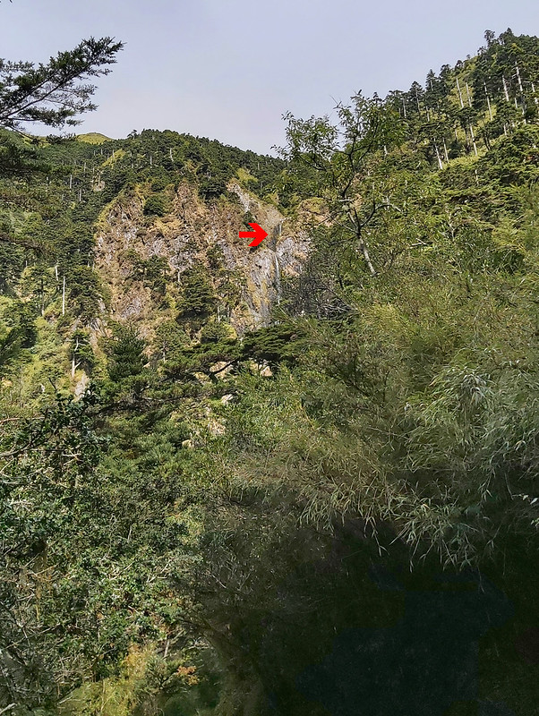
11:30 We passed No. 4 Suspension Bridge and visited Nenggao Waterfall.
I didn't remember crossing the bridge on the previous day because it was too dark. Fangyi suggested we visit
Nenggao Waterfall, aka Sandie Waterfall 能高瀑布 or 三疊瀑布, so we took a detour to explore. It turned out to be a
great decision.

The waterfall was about 200 meters high, so high that I could only see the first layer of the waterfall.
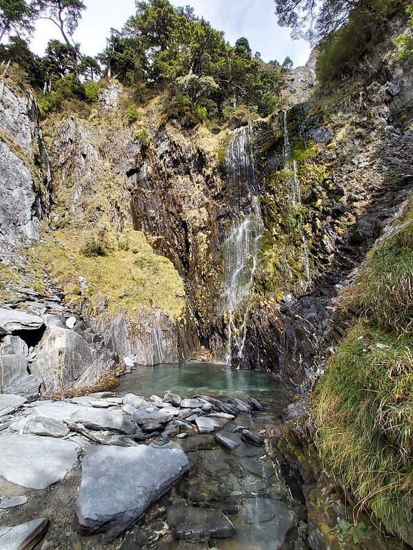
Moreover, the pool of the water was crystal clear and beautiful. I was tempted to dip my toes in the water, but
I remembered it was winter and must be icy cold. It would be great to do that in summer.
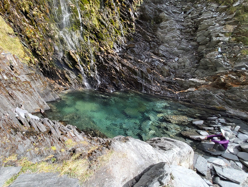
Later, I found out I had taken a photo of the upper layers of Nenggao Waterfall after we had just left Tianchi
Lodge without knowing it.
11:55 Saw powerline near Kuang Pei Pa Piao Monument. During my first visit, our
guide told us that we could see the powerline near Kuang Pei Pa Piao Monument. I saw it again this time. When
you visit, remember to look for the powerline at around the 12k mark.
14:16 We passed the unstable rock slope.
16:00 We got back to the trailhead (I forgot to record when we arrived at
Yuanhai Line Station). Our van was there waiting for us.
About Qilai Nanhua Hike and Other Trails Nearby
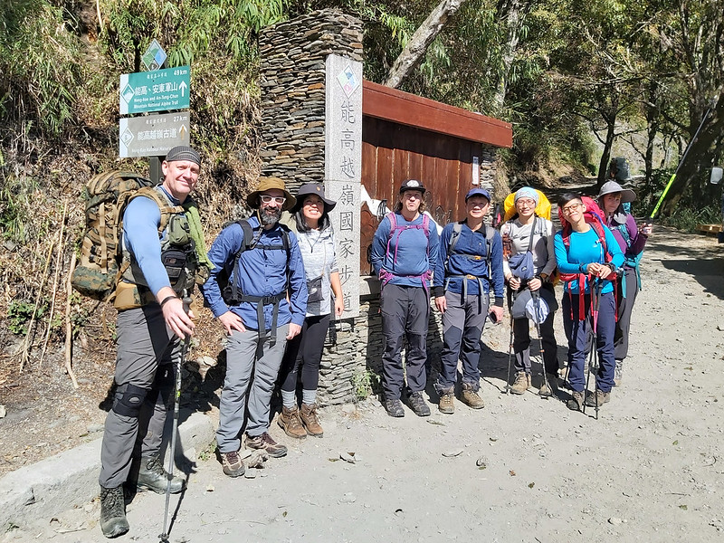
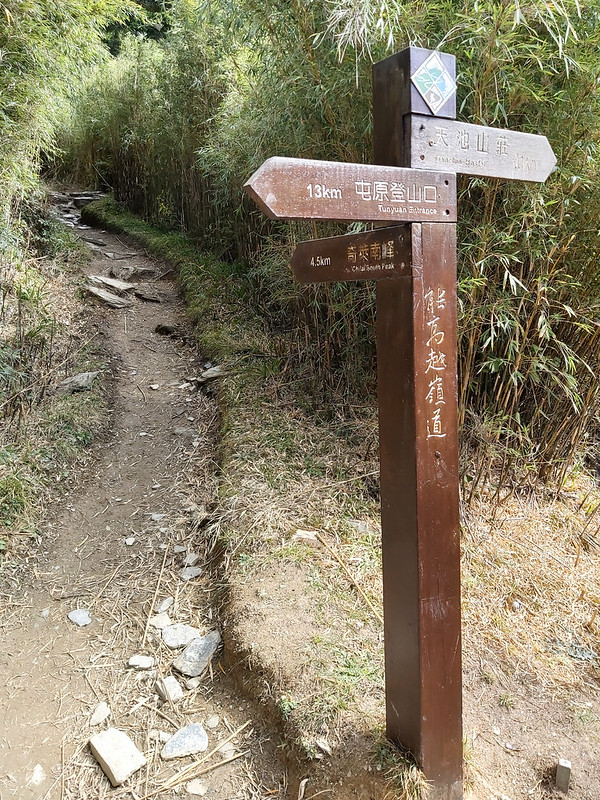
When you arrive at Tunyuan Trailhead 屯原登山口 (height: 2,041 meters/6,696 feet), you will see two signs, the top
one in green with 49 km is Neng-Kao and An-Tung-Chun (aka Nenggao Andongjun) Mountain National Alpine Trail
能高安東軍山, and the brown one in the bottom with 27 km is Neng-Kao National Historical Trail (aka Nenggao
Cross-Ridge Trail).

You'll have to go from Tunyuan Trailhead to Kuang Pei Pa Piao Monument no matter which one you take. If you only
hike Mt. Qilai South Peak and Mt. Nanhua, hiking to Kuang Pei Pa Piao Monument is optional.

Mt. Qilai South Peak and Mt. Nanhua
There are two 100 Peaks on the hike, Mt. Qilai South Peak and Mt. Nanhua. Because the pronunciation in
mandarin south is "nan," the short name for this trail is Qilai Nanhua 奇萊南華. The full title is Qilai Nan Feng
(Feng means peak), Nanhua Shan. So I'll use the short name Qilai Nanhua here.
Qilai Nanhua is one of the entry-level hikes among 100 Peaks. Because this trail is easy with good accommodation
with meals and sleeping bags to rent, this trail has attracted many hikers and non-hikers. As you can imagine,
it can be very crowded on the trail during the weekends or extended holidays.

Neng-Kao National Historical Trail, aka Nenggao Cross-Ridge Trail 能高越嶺古道
The total distance of Nenggao Cross-Ridge Trail is 27 km (16.7
miles), and it starts from Tunyuan Trailhead to Tongmen Village in Sioulin, Hualien, 花蓮縣秀林鄉銅門村.
You can choose to start this hike from Tongmen. It usually takes 3 days to finish this one, and its difficulty
level is moderate. There are no 100 Peaks on this trail, but you can put Mt. Qilai South Peak and Mt. Nanhua on
your itinerary.
Before Nenggao Cross-Ridge Trail was built, those separate trails were initially used as hunting trails by the
indigenous people, Atayal people 泰雅族 and Seedig people 賽德克族.
During the Japanese Occupation, Nenggao Cross-Ridge Trail was built to help them rein the indigenous people. At
that time, the Japanese colonial government also started establishing infrastructure.
It had established several power plants in Tongmen, Qingshui, and other places in eastern Taiwan, which had
produced more electricity than eastern Taiwan needed.
Therefore, the Japanese colonial government decided to transmit the excess electricity to western Taiwan during
the late WWII. After WWII was over and Japan surrendered, Japan handed Taiwan over to Kuomintang, whose chairman
was Chiang Kai-Shek. However, this project of east-west power transmission was also brought to a halt due to the
chaos and lack of funding.
The United States of America government funded USD 400,000, equivalent in purchasing power to about $7.4 million
today, to Taipower Company to carry on this electricity transmission project in 1950.

According to the research done by Xu Rulin and Yang Nanjyun, authors of The Story of the Nengao
National Trail, an indigenous woman said she was recruited (forced to be exact) to build this project
while being pregnant. She had to carry 50 kg (110 pounds) of cement every day and was paid NT$5, and men had to
take 100 kg (110 pounds) and were paid NT$10 per day.
Finally, this project finished in 1953, and Taipower Company constructed a monument to commemorate this
achievement. Chiang Kai-Shek, the president at that time, signed “光被八表, 利溥民生 Kuang Pei Pa Piao, Li Pu Min Sheng” on the monument, meaning this
project was like "light shining covers the eight dimensions and benefits civil life." This monument is located
right on the ridge, the border between Nantou County and Hualien County, and has become a must-visit place among
hikers.

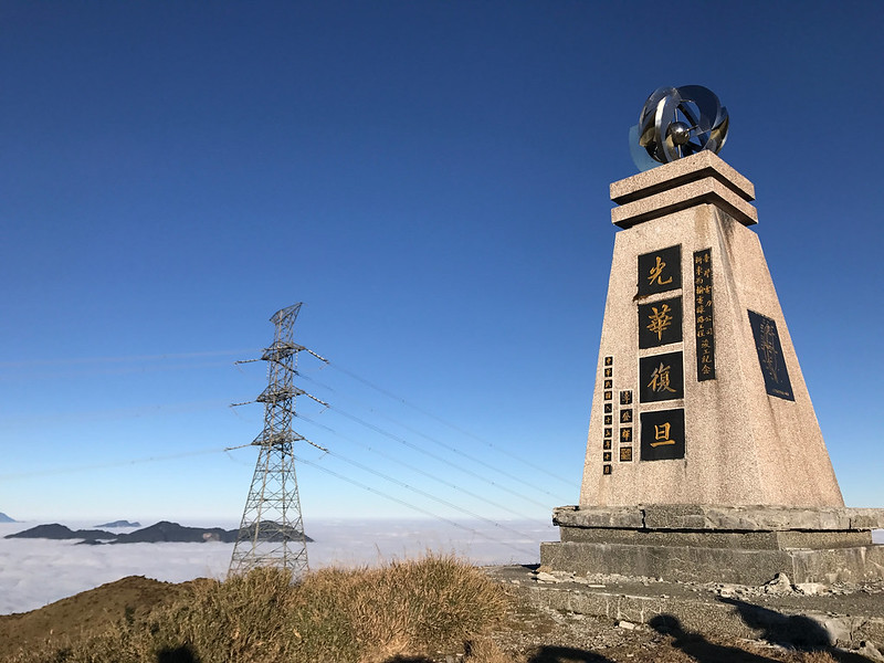
In 1989, another power transmission project started on Danda Forest Road, and a second monument called 光華復旦紀念碑 Guan Hua Fu Dan Monument was set up near Qicai Lake in 1998. You can
read my hike to Mt.
Liushun and Qicai (Cicai) Lake for more details.
Nenggao An-Tung-Chun Mountain National Alpine Trail, North Section 3 能高安東軍(北三段)
Nenggao Andongjun Mountain Alpine Trail 能高安東軍, also called North Section 3 of the Central Mountain Range 北三段, is
more challenging and takes at least 6 days to hike. There are five 100 Peaks on this trail:
- Mt. Nenggao Main Peak 能高主山, height 3,262 meters (10,702 feet)
- Mt. Nenggao South Peak 能高山南峰, height 3,349 meters (10,987 feet)
- Mt. Guantou (meaning bald head in English) 光頭山, height 3,060 meters (10,039 feet)
- Mt. Baishih 白石山, height 3,110 meters (10,203 feet)
- Mt. Andongjun 安東軍山, height 3,068 meters (10,066 feet)


High Altitude Sickness and Misassumption
High altitude sickness is no joke. It can happen to anyone, whether you are a
seasoned hiker or not. You'll have to let your hiking mates know whenever you feel weird, no matter how tiny
those symptoms are. I had a cold before our trip, and I was worried this might trigger altitude sickness, so I
visited my doctor before our hike and took some medicine.
There's a famous doctor in Taiwan, Dr. Wang 王士豪醫生, whose specialties are
treating high altitude sickness and other related illnesses. You can make an appointment with Dr. Wang and have
a thorough assessment before your hike.
A misassumption about high altitude sickness I hear a lot is it only happens when you reach a much higher
altitude. The mountains in Taiwan are not that high, so you usually don't have to worry about high altitude
sickness. This is wrong. People may start feeling ill after reaching an altitude of 2,440
meters.
If you want to know more about High Altitude Sickness, please check out this detailed post from YoWangdu Experience Tibet. A
quote from this post:
"The first symptoms of altitude sickness usually begin 2-24 hours after you arrive at altitudes over 8000 ft/2500 m. (Particularly after the first night at a new altitude.)"
Please let your hiking guide or mates know whenever you are feeling weird, no matter how tiny the symptoms are.
And, don't feel ashamed about feeling sick. High Altitude Sickness can happen to anyone.
How to Apply for Permits and Tianchi Lodge: Be Prepared to Apply for Several Times
1. You Need to Get a Bed or Campsite at Tianchi Lodge First.
Wild Camping Is Not Allowed.
-
1.1 Register to become a member on Tianchi Lodge homepage.
-
1.2 Click "Application" and read the rules before clicking AGREE. If you are a foreign national, you can
click PRIORITY RESERVATION FOR FOREIGNERS. However, those beds are only available on non-Taiwan-public
holidays and weekdays in Taiwan. If you wish to go on the weekend, you must go through the regular
application process.
Twelve beds are preserved for foreign nationals, and you can start applying 2 to 4 months before the date(s) you wish to stay at Tianchi Lodge.
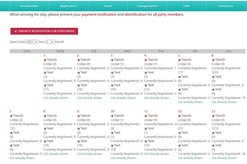
You can see how many hikers have applied for their stay at Tianchi Lodge
Q: I'm a foreign national. Can I hire one or more Taiwanese guides or go with my Taiwanese friends?
A: Of course, but please remember there's a ration requirement.
For a group of 5 or fewer hikers, you can only hire 1 Taiwanese guide or bring 1 Taiwanese friend.
For a group of 6 or more foreign nationals, the maximum of Taiwanese is 2.
If you have a large group (up to 12 people), the maximum of Taiwanese is 3.
If your group is more than 12 people, you have to split up your group and appoint different people to be the team leaders. Then proceed with the application process for each group. Thus, it's possible that some people may not win the lots.
Q: But what if our group wants to go with more Taiwanese people? Can we still apply?
A: Of course, just go with the regular process and draw lots if the demand exceeds the supply. If you go through the regular process, there are no preserved beds or campsites for you. For other applicants, the application date is open 2 months before the date you wish to stay at Tianchi Lodge.
For other applicants, the application date is open 2 months before the date you wish to stay at Tianchi Lodge.
You click the date on the calendar you wish to hike to the next forms. -
1.3 When selecting the date(s) you wish to stay in, you will see how many beds at the lodge and tents are
available and how many people have applied. But those numbers vary all the time. The official drawing date
is 30 days before the date you want to stay. The drawing time is 3:00 pm, and the results will be posted on
the Tianchi Lodge website after 3:30 pm.
You will get the email if you win the lot, but I didn't get that. Instead, I got an SMS notice at 3:40 pm on November 2, 2020, telling me to pay the fees within 5 days. - 1.4 What if I don't get any bed? You will have to wait to see whether there is any cancellation on the day you want to stay. I probably won't expect too much because this is a very popular trail. I will pick up another date and apply again. You can only choose between beds or a campsite, just one option at a time. Or split your group into several smaller ones.
-
1.5 If you go with a group, one person from your group or your guide should be responsible for applying.
Please note this person (aka your team leader) CANNOT be switched. If this person and your guide can't go,
you must cancel the whole group's application and try again. You can reduce the number of team members,
but it's not allowed to switch people.

The maximum number of people in one group is 12. You have to divide your groups into smaller ones if you have a large group. -
1.6 You can pay the fee with credit cards. Once you receive the notice that you have got beds/campsites, you
must pay the payment within 5 days. Here are the fees you pay:

Fees are different during weekdays and weekends. -
1.7 Cancelation
If things come up and you cannot go, please remember to cancel your stay on Tianchi Lodge's website. Otherwise, you and your whole team will get a penalty and can't apply for Tianchi Lodge again for 3 months to 1 year.
You will get a total refund if a typhoon alert is officially issued or the trail is closed due to natural disasters or construction. However, if you still want to go later, you can't just change the date. You have to apply again.
For other unforeseen reasons and you need to cancel your trip:
If your cancelation is accepted 6 days before your stay, you will get a total refund.
If you cancel your stay 4 or 5 days before your date, you will get a 50% refund.
If you cancel your stay 3 days before your date, you will not get a refund.
If there is any update, you should visit Tianchi Lodge's official page. -
1.8 Room Arrangements
There are five 4-person rooms (room numbers starting with 4), four 8-person rooms (room numbers starting with 8) on the second floor, and three 12-person rooms with bunk beds (room number starting with 12) on the first floor of the lodge. The lodge master will arrange your stay, but it's possible that your group might share the room with other hikers.
This is the 8-person room.
2. Apply for A Park Permit before Your Departure
We only need to apply for the permit for Mt. Qilai South Peak because it is at Taroko
National Park at least 5 days before your departure. Please read the rules and check all the boxes required
before clicking 'I Agree.'


Emergency Coordinator:
I have stressed the importance of having an emergency coordinator on my post of Mt. Dabajian and Mt. Xiaobajian. You must find a person who knows the trail and your
itinerary in case this person needs to contact the police for help on your behalf.
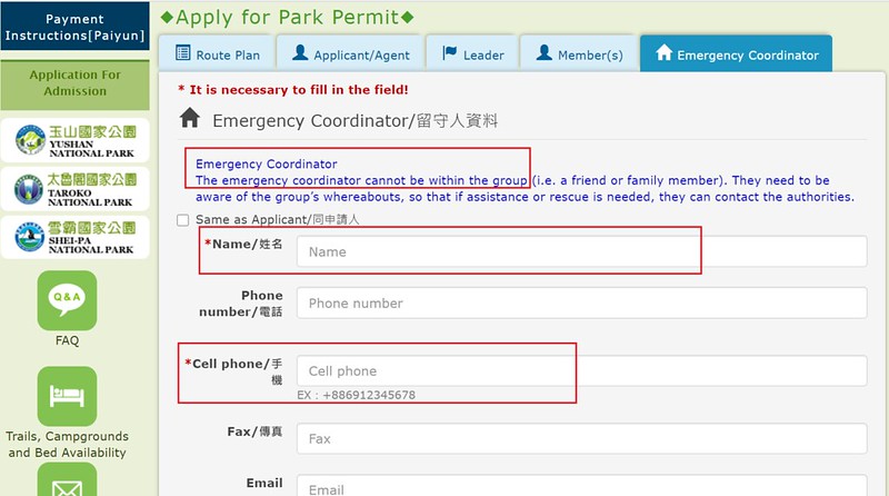
As usual, I asked Acer Lee, a seasoned hiking guide who is also fluent in English, to be our Emergency
Coordinator. He was very kind to help us and gave us advice.
3. No Need to Apply for the Police Mountain Entry Permit
4. Buy Travel Insurance and Hiking Insurance 登山綜合保險
When this post is published, five counties and cities in Taiwan, Miaoli County, Taichung City, Nantou County, Hualien County, and Pingtung
County, require hikers to buy Hiking Insurance before they hike 100 Peaks inside their territories.
If hikers need to call rescue, they will get a hefty fine for not complying with the regulations. Some even
require that at least one of the team members have a BLS (Basic Life Support) certificate. You'll also get a
fine later if none of your team members has one.

As to the insurance, I will buy both Travel Insurance and Hiking Insurance because they cover different things
even though some of them overlap. For example, hiking Insurance covers the rescue cost during your hike IF YOU
GO ACCORDING TO YOUR ORIGINAL PLAN, which means you will still be fined if you change your route and need to
call for help later.
5. After You Arrive at Tianchi Lodge:
-
5.1 Check-in with Lodge Master after 2 pm, leave your hiking boots out, and change to indoor slippers before
getting side the lodge. It's possible that you can't find any slippers if there are too many hikers staying.
When you check in, you need to have all team members' ID (Taiwanese ID card, passport, or ARC), a printout from the Taichi Lodge website that proves you and your team members have paid the fee.
A notice at the door of Tianchi Lodge to remind hikers about checking in - 5.2 Check in with 2860 Cabin to get meals, sleeping bags, and pads if you have ordered them in advance. If your group is big, remember to get some of your hiking mates to help carry those sleeping bags and pads. I forgot I had to take 6 sleeping bags and the nice guy at Tianchi Kitchen helped me bring some to our room.
- 5.3 Check-out Time: 11 am on the date of your departure. You have to return everything you rent before departure.
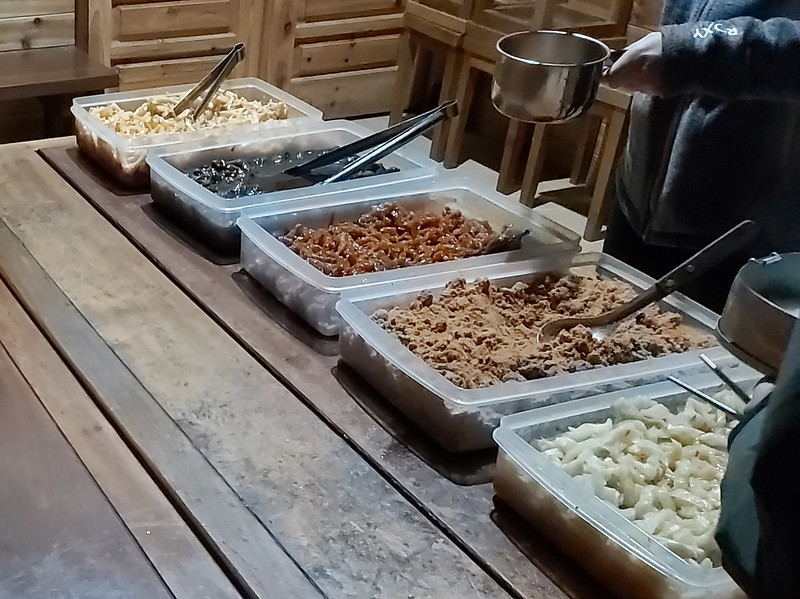
Meals, Sleeping Bags, Tents, and Pads
You can bring your stove and meals, but you are not allowed to cook in your rooms. So instead, you cook your
meals in the lodge's first-floor dining area.
Or you can book meals and rent sleeping bags, tents and pads with Miasan's 2860 Cabin. If you order meals,
you will also get a rented sleeping bag. Remember to bring your own utensils.
During my two hikes, a different company was in charge of the meals. So, I can't say how the meals are from
Miasan's 2860 Cabin.
2860 Cabin also has sleeping bags, pads, and tents for rent.
There are EVA form mats on those beds at Tianchi Lodge, but it's a personal preference to bring your sleeping
pad.

Acknowledgement and Related Posts:
I want to thank Sky, the lovely duo, Ami and Teresa from Taiwan Trails and Tales, Cris and
his beautiful girlfriend Fangyi, Walt, Glenn from OutRecording for being brave
enough to go hiking with me, and Acer Lee for being our emergency coordinator. Oh, Glenn got us this cool group
name, Brute Squad. You'll need a group name to apply for your stay at Tianchi Lodge.